U.S. flag

An official website of the United States government

Here’s how you know

Dot gov

Official websites use .gov
A .gov website belongs to an official government organization in the United States.

HTTPS

Secure .gov websites use HTTPS
A lock (LockA locked padlock) or https:// means you’ve safely connected to the .gov website. Share sensitive information only on official, secure websites.

    • Environmental Topics
    • Air
    • Bed Bugs
    • Chemicals and Toxics
    • Climate Change
    • Emergency Response
    • Environmental Information by Location
    • Environmental Justice
    • Greener Living
    • Health
    • Land, Waste, and Cleanup
    • Lead
    • Mold
    • Pesticides
    • Radon
    • Science Topics
    • Water Topics
    • A-Z Topic Index
    • Laws & Regulations
    • By Business Sector
    • By Topic
    • Compliance
    • Enforcement
    • Guidance
    • Laws and Executive Orders
    • Regulations
    • Report a Violation
    • Environmental Violations
    • Fraud, Waste or Abuse
    • About EPA
    • Our Mission and What We Do
    • EPA Administrator
    • Headquarters Offices
    • Regional Offices
    • Labs and Research Centers
    • Planning, Budget, and Results
    • Organization Chart
    • EPA History
    • Staff Directory
Radiation Protection
Contact Us

RadMap

Please be Advised

RadMap is a government product for use by government and the military only. An appropriate email address (.mil or .gov) is required for access.

person standing next to a monitor

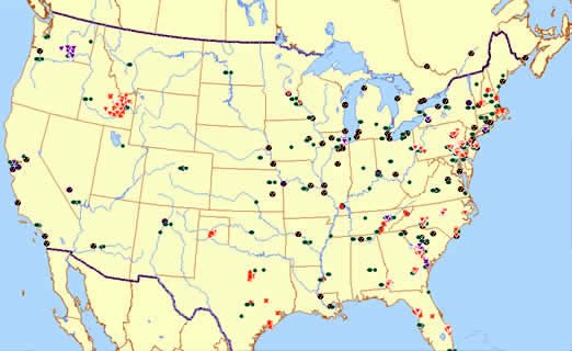
Designed for use by emergency responders, especially when the internet is unavailable, RadMap is an interactive desktop tool featuring a nationwide geographic information systemsA system for linking information to a particular geographical location. A Geographic Information System (GIS) allows users to manipulate and analyze specific provided data. (GIS) map of long-term radiation monitoring locations across the United States with access to key information about the monitor and the area surrounding it.

In the event of the radiation release RadMap can help emergency responders collect information, develop assessments, and determine the placement of deployable monitors. Desktop access could be critical should other systems fail in an emergency. RadMap helps EPA in its Homeland Security responsibilities and it was recommended by the Conference of Radiation Control Program Directors and EPA’s Science Advisory Board (SAB).

Map of RadMap Monitors

RadMap provides easy access to:

  • Monitor locations.
  • Points of contact for specific monitoring systems.
  • What data is being collected and how often.
  • Real-time and long-term data, where available online.
  • Geographic features such as nearby roads and bodies of water.
  • Mileage of locations from other points on the map.

Users can highlight an area to identify key information about the monitor and to characterize the monitor location.

View the RadMap fact sheet to learn more about RadMap use and capabilities.

EPA RadMap Request Form
Note: This file may require approximately 30 minutes to download with a high speed connection and several hours with a slow connection

  • Radiation Protection Home
  • Radiation Basics
  • Radiation Dose Calculator
  • Radiation Regulations & Laws
  • Federal Guidance for Radiation Protection
  • Radiological Emergency Response
  • TENORM
  • Radiation Protection Document Library
  • Frequent Questions
  • Glossary
Contact Us to ask a question, provide feedback, or report a problem.
Last updated on March 21, 2022
United States Environmental Protection Agency

Discover.

  • Accessibility Statement
  • Budget & Performance
  • Contracting
  • EPA www Web Snapshot
  • Grants
  • No FEAR Act Data
  • Plain Writing
  • Privacy
  • Privacy and Security Notice

Connect.

  • Data.gov
  • Inspector General
  • Jobs
  • Newsroom
  • Open Government
  • Regulations.gov
  • Subscribe
  • USA.gov
  • White House

Ask.

  • Contact EPA
  • EPA Disclaimers
  • Hotlines
  • FOIA Requests
  • Frequent Questions

Follow.