U.S. flag

An official website of the United States government

Here’s how you know

Dot gov

Official websites use .gov
A .gov website belongs to an official government organization in the United States.

HTTPS

Secure .gov websites use HTTPS
A lock (LockA locked padlock) or https:// means you’ve safely connected to the .gov website. Share sensitive information only on official, secure websites.

    • Environmental Topics
    • Air
    • Bed Bugs
    • Chemicals and Toxics
    • Climate Change
    • Emergency Response
    • Environmental Information by Location
    • Environmental Justice
    • Greener Living
    • Health
    • Land, Waste, and Cleanup
    • Lead
    • Mold
    • Pesticides
    • Radon
    • Science Topics
    • Water Topics
    • A-Z Topic Index
    • Laws & Regulations
    • By Business Sector
    • By Topic
    • Compliance
    • Enforcement
    • Guidance
    • Laws and Executive Orders
    • Regulations
    • Report a Violation
    • Environmental Violations
    • Fraud, Waste or Abuse
    • About EPA
    • EPA Administrator
    • Organization Chart
    • Staff Directory
    • Planning, Budget, and Results
    • Jobs and Internships
    • Headquarters Offices
    • Regional Offices
    • Lab and Research Centers
Related Topics:
  • Emergency Response to Gold King Mine Release
Contact Us

Gold King Mine Data, August 12, 2015

Free viewers may be needed to access information linked on this page.

Data from Gold King Mine Response

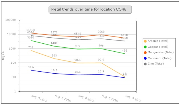
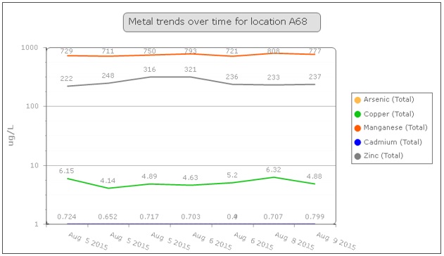
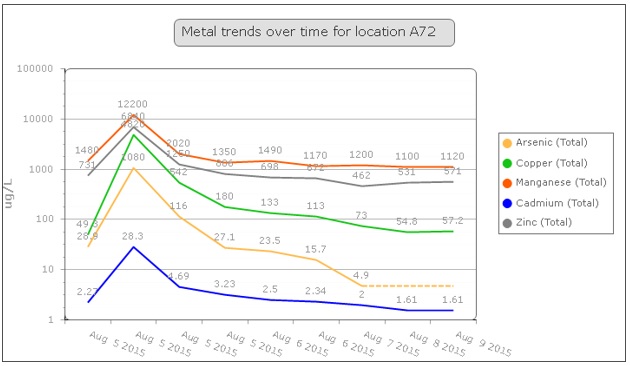
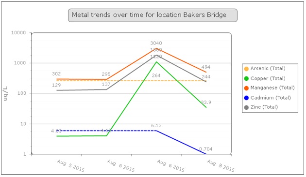
August 12, 2015: To assess the impacts of the release at the Gold King Mine near Silverton, Colorado, water quality samples were collected at numerous intervals beginning on Aug. 5, 2015. Samples were taken prior to the plume’s arrival to establish a baseline for water quality comparisons. Each surface water sample was analyzed for 24 metals, including arsenic, cadmium, lead and mercury.

Analysis now shows that water quality for the Animas River from the Silverton, Colo. area to the Durango municipal water intake has returned to pre-event water quality levels. These results are based on validated sampling data collected from Aug. 5 to Aug. 9, 2015.

EPA has shared this data with state, local and tribal officials in Colorado to assist them in their decisions regarding the on-going use of water resources. EPA plans to continue to monitor, analyze and share data for downstream river segments as it becomes available.

  • Open or download the data file: Surface Water Summary Table (xlsx) (222.52 KB)

Map of sampling locations

Metal Trends Over Time for Location CC48
Metal Trends Over Time for Location A68
Metal Trends Over Time for Location A72
Metal Trends Over Time for Location Bakers Bridge

Contact Us to ask a question, provide feedback, or report a problem.
Last updated on November 16, 2021
United States Environmental Protection Agency

Discover.

  • Accessibility
  • Budget & Performance
  • Contracting
  • EPA www Web Snapshot
  • Grants
  • No FEAR Act Data
  • Plain Writing
  • Privacy
  • Privacy and Security Notice

Connect.

  • Data.gov
  • Inspector General
  • Jobs
  • Newsroom
  • Open Government
  • Regulations.gov
  • Subscribe
  • USA.gov
  • White House

Ask.

  • Contact EPA
  • EPA Disclaimers
  • Hotlines
  • FOIA Requests
  • Frequent Questions

Follow.