U.S. flag

An official website of the United States government

Here’s how you know

Dot gov

Official websites use .gov
A .gov website belongs to an official government organization in the United States.

HTTPS

Secure .gov websites use HTTPS
A lock (LockA locked padlock) or https:// means you’ve safely connected to the .gov website. Share sensitive information only on official, secure websites.

    • Environmental Topics
    • Air
    • Bed Bugs
    • Cancer
    • Chemicals, Toxics, and Pesticide
    • Emergency Response
    • Environmental Information by Location
    • Health
    • Land, Waste, and Cleanup
    • Lead
    • Mold
    • Radon
    • Research
    • Science Topics
    • Water Topics
    • A-Z Topic Index
    • Laws & Regulations
    • By Business Sector
    • By Topic
    • Compliance
    • Enforcement
    • Laws and Executive Orders
    • Regulations
    • Report a Violation
    • Environmental Violations
    • Fraud, Waste or Abuse
    • About EPA
    • Our Mission and What We Do
    • Headquarters Offices
    • Regional Offices
    • Labs and Research Centers
    • Planning, Budget, and Results
    • Organization Chart
    • EPA History

San Juan Watershed

  • Water Quality Monitoring in the Watershed

    Learn about long-term water quality monitoring activities for the San Juan watershed.

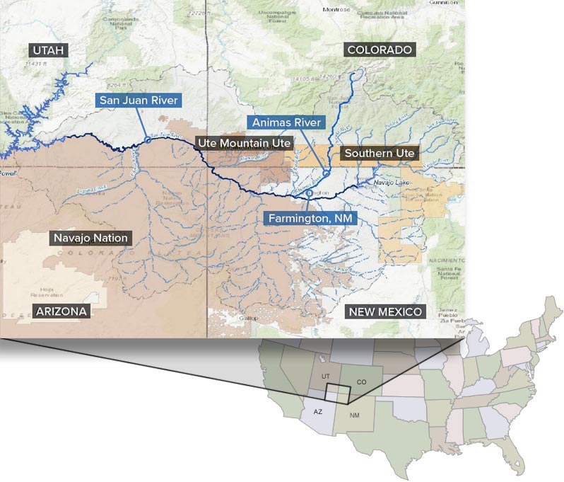
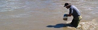
Water resources in the San Juan watershed, which encompasses the San Juan and Animas Rivers and Lake Powell, are essential for recreational, agricultural, cultural, and residential uses. Potential contamination sources within the watershed include historic mining activities that disturbed the land and exacerbated naturally occurring mineralization. In 2016, under the Water Infrastructure Improvements for the Nation Act, the U.S. Congress authorized appropriations of $4 million per year in 2017–2021 for a long-term water quality monitoring program for the San Juan watershed.

Current activities

EPA and the states and tribes adjoining the watershed - Arizona, Colorado, New Mexico, Utah, the Navajo Nation, the Ute Mountain Ute Tribe, and the Southern Ute Indian Tribe - are working together to develop and implement the long-term water quality monitoring program. They will:

  • Conduct collaborative annual water quality and sediment monitoring and determine the need for additional monitoring,
  • Communicate information about the condition of the watershed to the public,
  • Carry out targeted monitoring and research activities to inform state and tribe-specific decision-making for the watershed.

Basic Information

photo of kayakers on the river
  • San Juan Watershed Storymap Collection
  • Program Fact Sheets
  • Resources for the San Juan Watershed
  • WIIN Act

Monitoring

photo of a technician taking sampling in a river
  • Watershed Condition Fact Sheets
  • Monitoring Data and Map
  • Map of Water Quality Assessment Results

Implementation

Workers on a boat. Photo: Utah DEQ
  • San Juan Watershed WIIN Grant Guidance
  • State and Tribal Projects
  • Map and Summary of Watershed Plans

Partnerships

Animas River near Cedar Hill
  • Webinar Series
map showing San Juan watershed general area in CO, NM, AZ, UT
The San Juan watershed is located in the Four Corners area of the US southwest.
Contact Us to ask a question, provide feedback, or report a problem.
Last updated on March 10, 2025
  • Assistance
  • Spanish
  • Arabic
  • Chinese (simplified)
  • Chinese (traditional)
  • French
  • Haitian Creole
  • Korean
  • Portuguese
  • Russian
  • Tagalog
  • Vietnamese
United States Environmental Protection Agency

Discover.

  • Accessibility Statement
  • Budget & Performance
  • Contracting
  • EPA www Web Snapshot
  • Grants
  • No FEAR Act Data
  • Plain Writing
  • Privacy
  • Privacy and Security Notice

Connect.

  • Data
  • Inspector General
  • Jobs
  • Newsroom
  • Regulations.gov
  • Subscribe
  • USA.gov
  • White House

Ask.

  • Contact EPA
  • EPA Disclaimers
  • Hotlines
  • FOIA Requests
  • Frequent Questions
  • Site Feedback

Follow.