
Regional SDAMs FAQs
This page answers some of the most frequently asked questions about applying Regional SDAMs.
Questions on this page:
- How do you know that the Regional SDAM indicators accurately predict the streamflow duration class?
- What are random forest models?
- Is a Regional SDAM classification a jurisdictional determination under the Clean Water Act?
- Does the EPA offer a certification for using a Regional SDAM?
- Can Regional SDAMs be applied to created or altered channels?
- Are Regional SDAMs applicable when a stream goes subsurface in a portion of the assessment reach?
- Are Regional SDAMs applicable to streams that are not flowing?
- What if I’m on a border between SDAM regions, or in an area that is atypical of the region (e.g., a mountainous part of the Arid West)?
- If direct hydrological data is available for my site should I use a Regional SDAM?
- Is lab identification of aquatic macroinvertebrates required?
- Is there a database collecting the stream flow assessments resulting from using the Web Application for Regional SDAMs? Is it possible to request the data?
Question 1: How do you know that the Regional SDAM indicators accurately predict the streamflow duration class?
Answer: For each site used in the development of the SDAMs, streamflow duration class was determined hydrologically and independently of indicator data. Long-term hydrologic data from stream gages, hydrologic studies, repeat observations across years and seasons, or data loggers installed for this study were used. If streamflow duration could not be confidently identified by hydrologic data, the site was not included in the analysis. The combination of indicators in the Regional SDAMs were those that accurately predicted stream flow duration for the training datasets (80% of the data) and also most accurately predicted streamflow duration for the testing dataset (20% of the data that was new to the model). The models are very good at distinguishing ephemeral streams from intermittent streams, but less so at distinguishing perennial streams from intermittent streams.
Question 2: What are random forest models?
Answer: Random forest models are a machine learning modeling method that uses many decision trees based on randomly selected subsets of indicators and training data, collectively called a “forest,” to predict the streamflow classification. Decision trees can be visualized as a flow chart of conditions that can be used to most accurately classify or predict outcomes. Each decision tree is a subset of the geomorphological, hydrological, and biological metrics identified as most important for making consistent and accurate classifications of streamflow duration for a random subset of training data. Note that the relationship between any one indicator value and the resulting classification can be quite complex and dependent on the relationship between indicators in the decision trees. Learn more about random forest modeling for making classification predictions.
Question 3: Is a Regional SDAM classification a jurisdictional determination under the Clean Water Act?
Answer: No, the classification resulting from application of a Regional SDAM is not a jurisdictional determination under the Clean Water Act. Regional SDAMs are a rapid, field-based methods for classifying the flow duration of a stream reach. Use of the Regional SDAMs may inform a range of activities where information on streamflow duration is useful, including jurisdictional determinations under the Clean Water Act. Regulatory agencies evaluate aquatic resources for jurisdiction based on applicable regulations, guidance, caselaw, and policy.
Question 4: Does the EPA offer a certification for using a Regional SDAM?
Answer: No. The EPA does not offer a certification process for using the Regional SDAMs.
Question 5: Can Regional SDAMs be applied to created or altered channels?
Answer: Yes, Regional SDAMs can be used, in combination with best professional judgment, to assess the flow duration of created channels or stream reaches that have been highly modified. The EPA and the Corps have observed that some hydrologic and biologic indicators tend to persist (wetland plants, for instance, may occur on the margins of the channel) even with frequent maintenance of the created or altered channels. When applying these methods in created channels or modified streams, note that the site is a “disturbed site/difficult situation” and describe it in the “notes.”
Question 6: Are Regional SDAMs applicable when a stream goes subsurface in a portion of the assessment reach?
Answer: Streams observed flowing subsurface during the assessment visit may flow on the surface during wetter times of the year; therefore, it is important to check the entire reach for indicators of streamflow. In addition, the accuracy of an assessment can be improved by conducting a follow-up visit during a wetter time of the year. Assessment reach placement should maximize the homogeneity of drivers of streamflow duration (e.g., valley morphology), and should not consider the presence or absence of surface water at the time of assessment.
Question 7: Are Regional SDAMs applicable to streams that are not flowing?
Answer: Yes. The beta and Regional SDAMs apply to perennial, intermittent, and ephemeral streams and can been conducted in flowing or non-flowing conditions. Ephemeral reaches flow only in direct response to precipitation and intermittent reaches are channels that contain sustained flowing water for only part of the year, typically during the wet season. Both are often assessed when they are not flowing.
Question 8: What if I’m on a border between SDAM regions, or in an area that is atypical of the region (e.g., a mountainous part of the AW)?
Answer: The SDAMs are intended only for application within their region. Testing during the
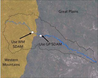
development of methods shows a drop in accuracy when applying a neighboring SDAM. The Web Application for Regional SDAMs alerts users if they select a location within 10 miles of a regional border to ensure they apply the appropriate regional method. However the boundaries used for the regional SDAMs are at a scale that may have missed pockets of the landscape that are more like a neighboring SDAM. If you are near the boundary or in an area that better matches a neighboring region, it may be helpful to assess reaches with both regional SDAMs. However, classifications resulting from application of a neighboring regional method are for informational purposes only. For more information see Development of Regional SDAMs.
Question 9: If direct hydrological data are available for my site, should I use a Regional SDAM?
Answer: No, direct hydrologic data are preferable to using the SDAMs. The SDAMs were developed for use where hydrologic data are not available.
Question 10: Is lab analysis of aquatic macroinvertebrates required?
Answer: No, lab analysis of aquatic macroinvertebrates is not required. It is recommended for those who are not familiar with aquatic macroinvertebrate identification to the taxonomic level required for the Regional SDAM indicators, or for situations where verification of the identifications is desired.
Question 11: Is there a database collecting the stream flow assessments resulting from using the Web Application for Regional SDAMs? Is it possible to request the data?
Answer: The Web Application for Regional SDAMs is only an analysis tool; it does not store any data. There is no database collecting or retaining the data or results from anyone utilizing the Web Application for Regional SDAMs.