U.S. flag

An official website of the United States government

Here’s how you know

Dot gov

Official websites use .gov
A .gov website belongs to an official government organization in the United States.

HTTPS

Secure .gov websites use HTTPS
A lock (LockA locked padlock) or https:// means you’ve safely connected to the .gov website. Share sensitive information only on official, secure websites.

    • Environmental Topics
    • Air
    • Bed Bugs
    • Cancer
    • Chemicals, Toxics, and Pesticide
    • Emergency Response
    • Environmental Information by Location
    • Health
    • Land, Waste, and Cleanup
    • Lead
    • Mold
    • Radon
    • Research
    • Science Topics
    • Water Topics
    • A-Z Topic Index
    • Laws & Regulations
    • By Business Sector
    • By Topic
    • Compliance
    • Enforcement
    • Laws and Executive Orders
    • Regulations
    • Report a Violation
    • Environmental Violations
    • Fraud, Waste or Abuse
    • About EPA
    • Our Mission and What We Do
    • Headquarters Offices
    • Regional Offices
    • Labs and Research Centers
    • Planning, Budget, and Results
    • Organization Chart
    • EPA History

Breadcrumb

  1. Home
  2. Great Lakes AOCs

Cuyahoga River AOC Boundary Map

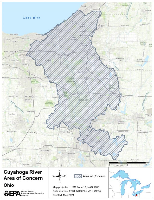
The Cuyahoga River AOC boundaries, established in 1988, originally included the lower 45 miles of the river from the Ohio Edison Gorge Dam at River Mile 45.1 in Cuyahoga Falls to the mouth of Lake Erie as well as approximately 10 miles of Lake Erie shoreline, from Edgewater Park on the west side of Cleveland to Wildwood Park on the east.

The Cuyahoga River AOC includes drainage from Big Creek, West Creek, Mill Creek, Tinkers Creek, Sagamore Creek, Chippewa Creek, Brandywine Creek, Furnace Run, Yellow Creek, Sand Run, Mud Brook, Euclid Creek, Doan Brook, and Dugway-Ninemile-Green Creeks. These watersheds are within Cuyahoga, Lake, Medina and Summit counties. The AOC includes the Cuyahoga Valley National Park, which preserves 22 miles of river between the primary urban/industrial centers of Akron and Cleveland. On July 21, 2010, the upper AOC boundary was extended to River Mile 46.5, which encompasses the Gorge Dam pool and its sediments.

map showing the state approved boundary of the Cuyahoga River AOC

The following files are available for download for the Cuyahoga River AOC:

  • Cuyahoga River AOC Shapefile (zip)
  • Cuyahoga River AOC Boundary Map (kmz)
  • Cuyahoga River AOC Boundary Map (pdf) (1.27 MB)
  • Cuyahoga River Boundary KMZ Metadata (pdf) (185.18 KB)

Great Lakes AOCs

  • The Great Lakes
  • Great Lakes AOCs Home
  • AOC List, Map and Contacts
  • Beneficial Use Impairments
  • Remedial Action Plans
  • Great Lakes Legacy Act
Contact Us About Great Lakes AOCs
Contact Us to ask a question, provide feedback, or report a problem.
Last updated on October 23, 2024
  • Assistance
  • Spanish
  • Arabic
  • Chinese (simplified)
  • Chinese (traditional)
  • French
  • Haitian Creole
  • Korean
  • Portuguese
  • Russian
  • Tagalog
  • Vietnamese
United States Environmental Protection Agency

Discover.

  • Accessibility Statement
  • Budget & Performance
  • Contracting
  • EPA www Web Snapshot
  • Grants
  • No FEAR Act Data
  • Plain Writing
  • Privacy
  • Privacy and Security Notice

Connect.

  • Data
  • Inspector General
  • Jobs
  • Newsroom
  • Regulations.gov
  • Subscribe
  • USA.gov
  • White House

Ask.

  • Contact EPA
  • EPA Disclaimers
  • Hotlines
  • FOIA Requests
  • Frequent Questions
  • Site Feedback

Follow.