
Water in Arkansas
On this page:
Water Topics
When the water in our rivers, lakes, and oceans becomes polluted; it can endanger wildlife, make our drinking water unsafe, and threaten the waters where we swim and fish. EPA research supports efforts under the Clean Water Act and Safe Drinking Water Act.
Please visit EPA's main Water Topics page for more information.
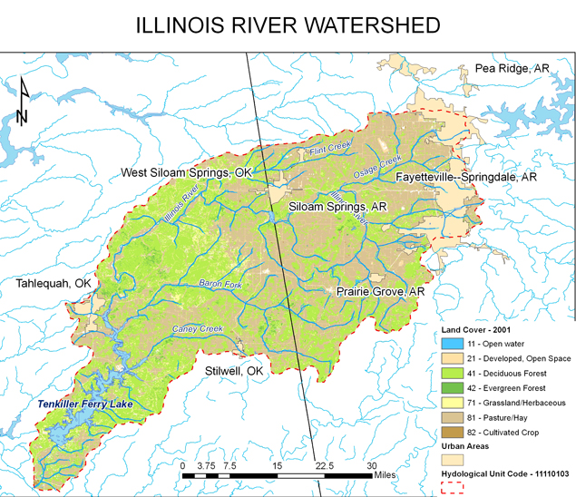
Illinois River Watershed
The Illinois River is a multi jurisdictional tributary of the Arkansas River, approximately 100 miles (160) km) long, between the States of Arkansas and Oklahoma. The Illinois River begins in the Ozark Mountains in the northwest corner of Arkansas (Washington County) and flows west into northeast Oklahoma. Once the Illinois River enters Oklahoma, it then flows southwest and south through the mountains of eastern Oklahoma into Tenkiller Ferry Lake. The Illinois River in Oklahoma is currently on the 303(d) list for total phosphorus, while tributaries to the Illinois River (e.g. Osage Creek, Muddy Fork, and Spring Creek) in Arkansas are also on the 303(d) list for total phosphorus.
Project Updates
Current Phase – Watershed and Lake Calibration/Validation Modeling
The calibration/validation modeling is complete for both Illinois River and Lake Tenkiller. The purpose of the calibration/validation modeling is to ensure a scientifically sound modeling system is developed to represent the entire Illinois River Watershed. Calibration modeling was performed using data obtained from the time period of 2001 to 2009, whereas data obtained from the 1992 to 2000 period of record was used for validation purposes. Calibration and validation of the Illinois River Watershed models was achieved by considering qualitative and quantitative measures, involving both graphical comparisons and statistical tests.
Events and Activities
Modeling complete September 2015
Technical Memorandum-Procedures and Methodologies for the Sensitivity and Uncertainty Analyses for Illinois River Watershed and Tenkiller Ferry Lake, Oklahoma describes the model sensitivity analysis and uncertainty analysis performed for Illinois River Watershed HSPF model and Tenkiller Ferry Lake EFDC model.
Final SA UA Technical Memo_08_07_2015
The Response to Statement of Findings explains the findings from the two peer reviewers based on their evaluation of the final reports developed by U.S. EPA contractors for the Agency’s Illinois River Watershed (IRW) TMDL Modeling Program.
Response to Statement of Findings- Final_8_4_2015
The Final Watershed Lake Model Main Report contains the Final Setup, Calibration, and Validation for Illinois River Watershed Nutrient Model and Tenkiller Ferry Lake EFDC Water Quality Model.
Final-Watershed Lake Model_Main Report 08_07_15
Appendices to the Final Watershed Lake Model Main Report
IRW_Report_Appendices_8_7_15
Project Manager
Leslie Rauscher
Water Division
EPA Region 6
214-665-2773