
Seabrook, NH Plans for Sea-Level Rise
New Hampshire’s coast is only 13 miles long, but it is home to seven coastal municipalities. To help its coastal municipalities evaluate environmental risks, the regional Rockingham Planning Commission (RPC) pooled resources from:
- The New Hampshire Homeland Security and Emergency Management (using a Pre-Disaster Mitigation Grant from the Federal Emergency Management Agency)
- New Hampshire’s Geographically Referenced Analysis and Information Transfer (GRANIT) System
- EPA’s Climate Ready Estuaries Program
As a result of this effort, in 2009 the RPC published the Adaptation Strategies to Protect Areas of Increased Risk from Coastal Flooding Due to Climate Change (PDF) (20 pp, 877 K, About PDF) and in 2015 it published the Tides to Storms Project (PDF) (52 pp, 2 MB, About PDF).
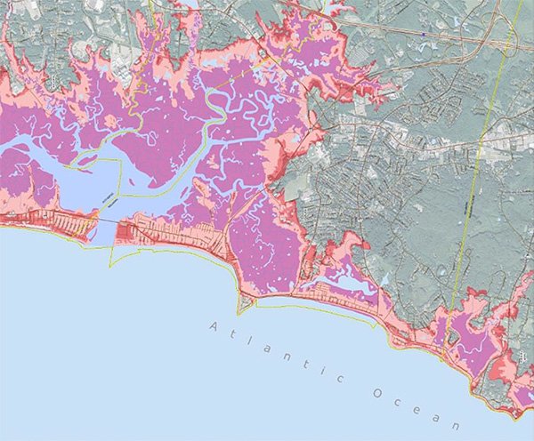
The project used coastal mapping data from the National Oceanic and Atmospheric Administration (NOAA) National Hurricane Center and LiDAR data collected by the United States Army Corps of Engineers as inputs to the COAST (Coastal Adaptation to Sea level rise) Tool. The COAST tool was then used to create visual, numeric, and presentation-based products that support the adaptation planning processes.
After accounting for regional subsidence, the COAST tool helped to project that by 2100 sea-level rise in New Hampshire could be approximately 2 to 5 feet.
The project also identified the vulnerability of each community’s assets and infrastructure from expected increases in storm surge and rates of sea-level rise. For example, if the ocean rises three feet by 2050, municipal and private assets in Seabrook, NH (worth between $107 million and $115 million) will be at risk during 100-year flood events.
The greatest identified risks were to:
- Sewage pump stations.
- The NextEra nuclear power station.
- An Elementary-Middle School property.
- A wastewater treatment plant.
- State and local roadways.
To address these risks in the short-term, the RPC recommended that Seabrook:
- Update its regulations and zoning to elevate new development.
- Separate development and infrastructure from tidal wetlands, freshwater wetlands and surface waters.
- Create a coastal flood hazard overlay district.
In addition, the RPC has made recommendations to improve long-term planning and strengthen community outreach and engagement.
| How did they do it? | Applicable EPA Tools |
|---|---|
A regional commission collected and analyzed data for multiple communities.
| |
Working meetings were used to help local government stakeholders increase their understanding of regional data.
| |
Seabrook used a regional vulnerability assessment to evaluate risks to its assets and infrastructure.
| The "Steps to Resilience" can help communities determine their vulnerabilities to potential changes in the environment. |
Leveraging regional planning, Seabrook used its resources for adapting rather than community-specific studies
| EPA’s Being Prepared For Climate Change Workbook outlines how communities of any size can take appropriate steps to develop a vulnerability assessment and risk-based plan. EPA's Coastal Inundation Coastal Storm Surge Scenario illustrates hurricane strike frequency and worst-case coastal storm surge or inundation scenarios. |
Similar Cases and More Information
- Anacortes, Washington Rebuilds Water Treatment Plant for Projected Risks
- Boston Raises Wastewater Facility to Avoid Inundation
- Maryland Analyzes Coastal Wetlands Susceptibility to Sea-Level Rise
- Southeast Florida Compact Analyzes Sea-Level Rise Risk
References
- Adaptation Strategies to Protect Areas of Increased Risk From Coastal Flooding Due to Climate Change: Seabrook, NH, 2009 (PDF) (20 pp, 877 K, About PDF)
- Planners urge preventive action as sea levels rise (2012)
- Rockingham Planning Commission, Regional & Community Planning, Climate Change
- Town of Seabrook, New Hampshire Vulnerability Assessment Report of sea-level rise and coastal storm surge flooding (PDF) (22 pp, 1.4 MB, About PDF)
- Floodplain Regulation: Challenges and Opportunities in Preparing for Climate Changes (2012 Webinar)