
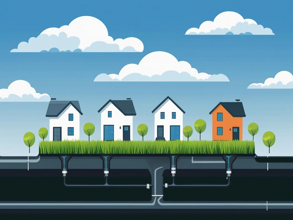
Sewersheds
The EPA National Sewershed Dataset provides polygon shapefiles of the “sewersheds” for certain publicly owned wastewater treatment works (POTWs). Similar to the concept of a watershed, a sewershed is the geographic area from which all the sewers flow to a single endpoint wastewater treatment facility. Understanding your POTW's service area is crucial for assessing the types of waste processed and the quality of treated discharge water. This information also supports local economic development, public health, and environmental quality.
The dataset includes both EPA-modeled sewersheds and those sourced directly from wastewater utilities and states. It is a dynamic product that benefits from public input to improve data accuracy and ensure comprehensive sewershed boundary data for all publicly owned wastewater systems.
For questions about this site or the data, please contact us at the CWNS Email Box (CWNS@epa.gov) and include “sewersheds map” in the subject line. The public can also contribute data or suggestions through the Sewershed Feedback Portal. EPA will review suggestions on a rolling basis for inclusion in the dataset and will contact you if additional information is needed.
- Home
- EPA’s Sewershed Boundaries Map
- Resources
- Frequently Asked Questions
EPA’s National Sewershed Dataset
Use Cases
Economic Growth: Identify opportunities for targeted infrastructure investment and expansion of services to unsewered communities.
Public Health: Monitor and predict community health trends as an early warning system through wastewater analysis and knowledge of the affected areas.
Community Awareness: Enable public access to information on where their wastewater goes. This information will also assist utility managers and local government with planning for the future.
Note: This map should not be used as an authoritative source for property-level connections. Sewershed boundaries can change due to growth and changes in inter-governmental agreements. Local governments are typically the most reliable source for determining whether a specific property is served by a centralized wastewater system.
Submit Feedback
For questions about this site or the data, please contact us at the CWNS Email Box (CWNS@epa.gov) and include “sewersheds map” in the subject line.
Use the Sewershed Feedback Portal to suggest corrections or submit sewershed shape files.
EPA’s Sewershed Boundaries Map
Scope
EPA developed a national dataset of wastewater sewershed boundaries map that includes nearly 17,000 publicly owned wastewater treatment works (POTWs) that cover roughly 78 percent of the U.S. population reported in the 2020 census (according to the 2022 Clean Watersheds Needs Survey, 82 percent of the U.S. population is served by POTWs). The POTWs in the dataset include “endpoint facilities” (meaning they are the last point of treatment before discharging to the environment) and POTWs where less than 50 percent of their wastewater is sent to another facility (meaning the majority of the wastewater receives its final treatment at that facility).
This dataset extends to all 50 states and Washington, D.C. Real sewersheds are used in lieu of modeled sewersheds wherever possible. Approximately 19 percent of the sewershed boundaries are from known sewersheds sourced online or directly from the state or utility. Future updates will aim to improve existing sewershed boundaries and add POTWs that are not currently in the dataset. For more detailed information, see the Sewershed Methods Documentation.
Methods and Attributes
In 2024, EPA released a model estimating drinking water service area boundaries. While similar, wastewater infrastructure requires a distinct model due to differences in system size and cost. The wastewater model uses EPA data sources like the 2022 Clean Watersheds Needs Survey and ICIS-NPDES, combined with census, land use, topography, and other public datasets, to predict service area extents using machine learning. State-provided and online sewershed maps were used to train the model after quality review.
The sewersheds are built using H3 Hexagons, a global grid system of uniformly sized hexagons, facilitating efficient statistical calculations. The model uses level 9 resolution, approximately 0.11 km². For more information on the model development, see the methods documentation and associated Github site.
Limitations
The POTWs’ locations and population served came from a combination of permit records and the 2022 Clean Watersheds Needs Survey results, which were self-reported by state staff during the survey. EPA could not verify data for all modeled POTWs. Some facilities were excluded when technical data proved unreliable (e.g., multiple POTWs using the same address). Privately-owned wastewater treatment facilities are not included in the dataset.
Sewershed boundaries are often changing; towns and cities grow and inter-governmental agreements change. Local government bodies are typically the most accurate source of information to determine whether a particular wastewater system serves a property. Their websites frequently have a “new resident information” page or a general information number. County and regional planning offices will also be able to provide guidance. Sewershed polygons on the map are color-coded to indicate whether the boundary is EPA-modeled or from an external data source.
Resources
Sewershed Documentation
2022 Clean Watersheds Needs Survey
2022 Clean Watersheds Needs Survey Dashboard
Wastewater treatment facilities reported in the 2022 Clean Watersheds Needs Survey were used as the base population for the sewersheds analysis. The survey dashboard provides visualizations, links to data downloads, and a copy of the Report to Congress.
Community Water System Service Area Boundaries
Community Water System Service Area Boundaries
Community Water System Service Area Boundaries is a national dataset that combines drinking water community water system service areas available from both published state sources supplemented with modeled boundaries. Browse the map on EPA’s GeoPlatform, download the data, and read more about the techniques EPA developed to create community water system service area.
Water Infrastructure and Capacity
Water Infrastructure and Capacity Assessment Tool (ICAT)
Water ICAT is a mapping application that supports the identification of drinking water and wastewater utilities that may benefit from water infrastructure technical assistance or capacity development assistance to provide affordable, safe water to communities.
Frequently Asked Questions
What are sewersheds?
Sewersheds are geographic areas that contribute wastewater to a specific publicly owned treatment works (POTW), known as an "endpoint." An endpoint is a facility that discharges less than 50 percent of its wastewater to another facility, meaning it is the final destination for the wastewater before it is released into the environment, typically into a water body like a river or ocean. A sewershed includes all collection systems and any intermediary POTWs that send their flow to the same endpoint. It can consist of a single collection system and POTW or a network of multiple POTWs and collection systems. The sewershed polygons in the dataset do not include information about individual (e.g., sewer) distribution lines – they are the approximation of the outermost boundary.
What types of POTWs are included in EPA’s sewershed boundary dataset?
The dataset includes POTWs reported in the 2022 Clean Watersheds Needs Survey that treat domestic waste and serve as the endpoint of their sewershed. It does not include privately-owned facilities, those that solely treat industrial waste, or facilities that send more than 50 percent of their effluent to another facility for further treatment.
What is the difference between the population shown for the POTW and the population shown for the sewershed boundary on the web map?
The population for the POTW is the number of people served by the facility and comes from the Clean Watersheds Needs Survey (CWNS). The population shown for the sewershed boundary is the estimated number of people residing within the boundary, according to the 2020 census. A large difference between these two numbers could indicate an error in the CWNS data or in the model boundary.
What are the benefits of having sewershed boundaries?
Understanding sewersheds helps connect wastewater system details with information about the communities served by the system, supporting various use cases and critical research to protect public health. Examples of use cases include:
- Economic Growth: Identify opportunities for targeted infrastructure investment and expansion of services to unsewered communities.
- Public Health: Monitor and predict community health trends as an early warning system through wastewater analysis and knowledge of the affected areas.
- Community Awareness: Enable public access to information on where their wastewater goes. This information will also assist utility managers and local government with planning for the future.
How were the sewershed boundaries developed?
The sewershed boundaries were created using data sourced online or from state agencies, along with modeled sewersheds. The modeled sewersheds were developed using the Clean Watersheds Needs Survey and ICIS-NPDES database to obtain location and population served for the POTWs. These were combined with U.S. Census, land use, topography, and other public datasets to predict the service area of each endpoint POTW using a machine learning model.
What are the limitations of this dataset?
The locations and populations served by POTWs were derived from permit records and the 2022 Clean Watersheds Needs Survey, which were self-reported by state staff. During model development, some data were found to be incorrect or outdated. In addition, sewershed boundaries can change due to growth and changes in inter-governmental agreements. This dataset should not be used as an authoritative source for property-level connections.
Does EPA plan to update this dataset?
Yes, the sewershed dataset will be updated as new or improved sewershed boundary data are available to EPA.
You can submit a sewershed boundary for the map through the Sewershed Feedback Portal.
I see an error in this dataset, who do I contact to correct this?
For questions or concerns, email the CWNS Email Box (CWNS@epa.gov) and include “sewersheds map” in the subject line.
You can submit a correction or data files through the Sewershed Feedback Portal.
For questions or to submit data corrections, email the CWNS Email Box (CWNS@epa.gov) and include “sewersheds map” in the subject line. You can also use the Sewershed Feedback Portal to suggest corrections or submit sewershed shape files.