
Ecoregion Download Files by State - Region 3
Notice
If you are having issues downloading the files on EcoRegions website, we recommend you try opening the site in another web browser. Or copy the link address to another tab to open the attachment in a new window.
Select a state for descriptive information about that state's Level III and IV ecoregions. Additionally, each state section contains links to downloadable maps in PDF format, and files containing GIS datasets (shapefiles, metadata, and symbology data).
NOTE: maps and GIS files may differ. To make sure you are using the most current ecoregion data, download shapefiles of ecoregions.
Region 3
Maps (available in PDF format)
- Level IV Ecoregions of EPA Region 3--42" X 34" (2.3 mb)
- Level III and IV Ecoregions of EPA Region 3 --page size (1.8 mb)
GIS Data (shapefiles, metadata and symbology)
- EPA Region 3 coverage (642 kb)
- EPA Region 3 metadata
- Delaware Shapefile (317 kb)
- Delaware metadata
- Maryland Shapefile (2 mb)
- Maryland metadata
- Pennsylvania Shapefile (517 kb)
- Pennsylvania metadata
- Virginia Shapefile (1.6 mb)
- Virginia metadata
- West Virginia Shapefile (642 kb)
- West Virginia metadata
Ecoregion Descriptions (MSWord documents)
| Map Thumbnails | |
|---|---|
|
|
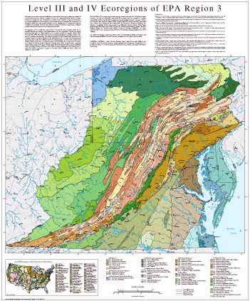
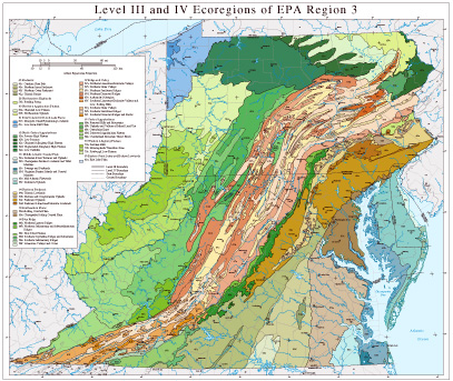
Ecoregions denote areas of general similarity in ecosystems and in the type, quality, and quantity of environmental resources; they are designed to serve as a spatial framework for the research, assessment, management, and monitoring of ecosystems and ecosystem components. Ecoregions are directly applicable to the immediate needs of state agencies, including the development of biological criteria and water quality standards and the establishment of management goals for nonpoint-source pollution. They are also relevant to integrated ecosystem management, an ultimate goal of most federal and state resource management agencies.
The approach used to compile this map is based on the premise that ecological regions can be identified through the analysis of the spatial patterns and the composition of biotic and abiotic phenomena that affect or reflect differences in ecosystem quality and integrity (Wiken 1986; Omernik 1987, 1995). These phenomena include geology, physiography, vegetation, climate, soils, land use, wildlife, and hydrology. The relative importance of each characteristic varies from one ecological region to another regardless of the hierarchical level. A Roman numeral hierarchical scheme has been adopted for different levels of ecological regions. Level I is the coarsest level, dividing North America into 15 ecological regions. Level II divides the continent into 52 regions (Commission for Environmental Cooperation Working Group 1997). At level III, the continental United States contains 104 regions (United States Environmental Protection Agency [USEPA], 2003). Level IV is a further subdivision of level III ecoregions. Explanations of the methods used to define the USEPA’s ecoregions are given in Omernik (1995), Griffith and others (1994), and Gallant and others (1989).
The level III and IV ecoregion map on this map was compiled at a scale of 1:250,000 and depicts revisions. It revises and subdivides earlier level III ecoregions that were compiled at a smaller scale (USEPA 2003; Omernik 1987). It includes previously published level IV ecoregions (Woods and Omernik, 1996; Woods and others, 1996). It expands level IV coverage to include, for the first time, western West Virginia and the Coastal Plain and Piedmont of Delaware, Maryland, and Virginia. Compilation of this map was part of a collaborative project with the United States Environmental Protection Agency (EPA) Region III Environmental Services Division, the EPA National Health and Environmental Effects Research Laboratory (NHEERL), and state environmental resource management agencies from Pennsylvania, Virginia, Maryland, and West Virginia.
For additional information, contact James M. Omernik, U.S. EPA National Health and Environmental Effects Laboratory (NHEERL), 200 SW 35th Street, Corvallis, OR 97333 (phone: 541-754-4458).
Literature Cited:
Bailey, R.G., Avers, P.E., King, T., and McNab, W.H., eds., 1994, Ecoregions and subregions of the United States (map) (supplementary table of map unit descriptions compiled and edited by McNab, W.H. and Bailey, R.G.): Washington, D.C., U.S. Department of Agriculture-Forest Service, scale 1:7,500,000.
Commission for Environmental Cooperation Working Group, 1997, Ecological regions of North America - toward a common perspective: Montreal, Quebec, Commission for Environmental Cooperation, 71 p.
Gallant, A.L., Whittier, T.R., Larsen, D.P., Omernik, J.M., and Hughes, R.M., 1989, Regionalization as a tool for managing environmental resources: Corvallis, Oregon, U.S. Environmental Protection Agency EPA/600/3-89/060, 152 p.
Griffith, G.E., J.M. Omernik, and S.H. Azevedo. 1998. Ecoregions of Tennessee. (Map poster). U.S. Geological Survey, Reston, VA.
Griffith, G.E., Omernik, J.M., Wilton, T.F., and Pierson, S.M., 1994, Ecoregions and subregions of Iowa - a framework for water quality assessment and management: The Journal of the Iowa Academy of Science, v. 101, no. 1, p. 5-13.
Omernik, J.M., 1987, Ecoregions of the conterminous United States (map supplement): Annals of the Association of American Geographers, v. 77, no. 1, p. 118-125, scale 1:7,500,000.
Omernik, J.M., 1995, Ecoregions-a framework for environmental management, in Davis, W.S. and Simon, T.P., eds., Biological assessment and criteria-tools for water resource planning and decision making: Boca Raton, Florida, Lewis Publishers, p. 49-62.
U.S. Department of Agriculture-Soil Conservation Service, 1981, Land resource regions and major land resource areas of the United States: Agriculture Handbook 296, 156 p.
U.S. Environmental Protection Agency, 2003, Level III ecoregions of the continental United States (revision of Omernik, 1987): Corvallis, Oregon, U.S. Environmental Protection Agency-National Health and Environmental Effects Research Laboratory Map M-1, various scales.
Wiken, E., 1986, Terrestrial ecozones of Canada: Ottawa, Environment Canada, Ecological Land Classification Series no. 19, 26 p. Woods, A.J., and Omernik, J.M., 1996, Ecoregions of Pennsylvania; Pennsylvania Geographer, v. XXXIV, no. 2, p. 3-37.
Woods, A.J., Omernik, J.M., Brown, D.D., and Kiilsgaard, C.W., 1996, Level III and IV Ecoregions of Pennsylvania and the Blue Ridge Mountains, the Ridge and Valley, and the Central Appalachians of Virginia, West Virginia, and Maryland: Corvallis, Oregon, U.S. Environmental Protection Agency, National Health and Environmental Effects Research Laboratory, EPA/600R-96/077, 50 p.
Woods, A.J., J.M. Omernik, C.S. Brockman, T.D. Gerber, W.D. Hosteter, and S.H. Azevedo. 1998. Ecoregions of Indiana and Ohio. (Map poster). U.S. Geological Survey, Reston, VA.
PRINCIPAL AUTHORS: Alan J. Woods (Dynamac Corp.), James M. Omernik (USEPA), and Douglas D. Brown (US Forest Service). Map preparation and development of digital files were provided by Jeffrey A. Comstock, Sandra H. Azevedo, M. Frances Faure, and Suzanne M. Pierson (OAO Corp.).