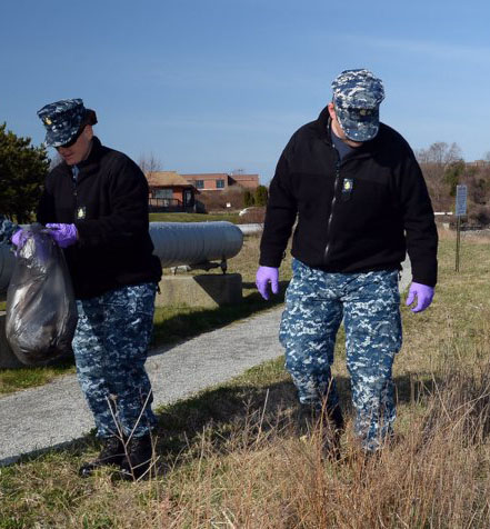
EPA Cleanup Case Studies
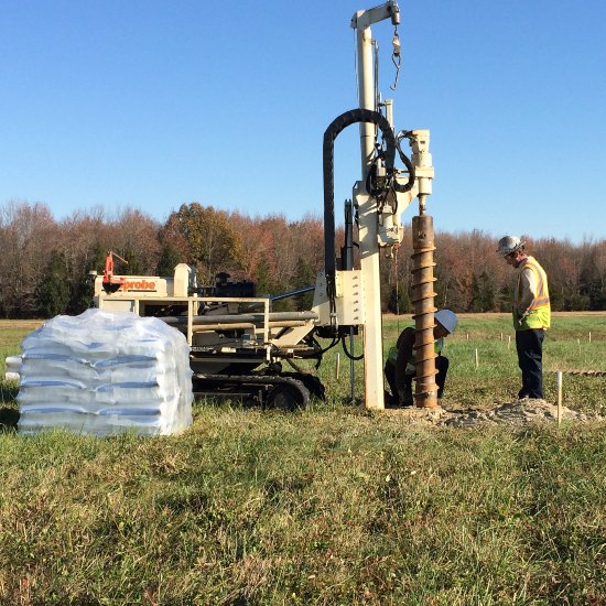
EPA works with the U.S. Department of War, the Department of Energy, and other federal agencies to develop creative, cost-effective solutions to environmental challenges at Federal Facility Superfund Sites. As part of these cleanups, quantities of materials are addressed through Remedial Actions at these sites. These activities represent an important step in the cleanup process (diagram of the Superfund Federal Facilities Cleanup Process).
EPA tracks the quantities of materials addressed annually
Media/Material | 2019 | 2020 | 2021 | 2022 | 2023 | 2024 | 2025 | 2019-2025 Totals |
|---|---|---|---|---|---|---|---|---|
Remedial Action Completion Count | 33 | 37 | 32 | 26 | 24 | 24 | 26 | 202 |
Groundwater (gallons) | 582,615,200 | 887,151,293 | 3,800,000,000 | 8,568,300,000 | 375,000,000 | 3,936,132 | 1,118,216,307 | 15,335,218,932 gallons |
Soil | 759,684 | 233,486 | 220,420 | 32,746 | 103,745 | 1,107,429 | 2,457,510 cubic yards | |
1,617,583 | 43,560 | 1,661,143 metric tons | ||||||
Debris | 149 | 519 | 34,707 | 91,548 | 6,821 | 19,330 | 34,359 tons | |
33,000 c | 1,359 | 34,359 cubic yards | ||||||
Sediment | 29,011 | 3,022 | 1,210 | 229,248 | 21 | 262,512 cubic yards | ||
2,237 | 2,237 acres | |||||||
31,157 | 31,157 tons | |||||||
Soil Gas (pounds) | 4,205 | 154 | 650 | 257,729 | 76 | 262,814 pounds | ||
Area protected through Land Use Controls (acres) | 2,584 | 9,846 | 1,950 | 2,397 | 1,736 | 963 | 33,547 | 53,023 acres |
Other | Prevented 529 pounds of uranium from reaching and contaminating groundwater | Treated 51,111 gallons of wastewater and liquid waste | Treated 220,000 gallons of wastewater and 66,586 gallons of hydrocarbons |
While the table details the quantities of materials addressed across the National program, you can better understand what these activities look like on a case by case basis by reading a site specific successes below:
Fort ORD
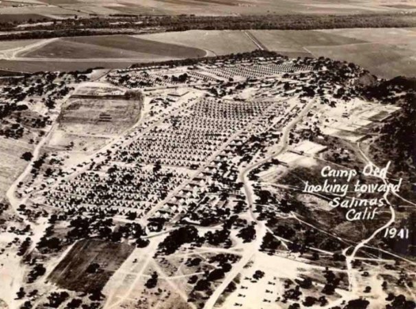

The 27,827-acre Fort Ord site is in Monterey County, California, approximately 80 miles south of San Francisco. Since 1917, portions of the former Fort Ord were used by cavalry, field artillery, and infantry units for maneuvers, target ranges, and other purposes. From 1947 to 1974, Fort Ord was a basic training center. After 1975, the 7th Infantry Division occupied Fort Ord. Fort Ord was selected for closure in 1991 and was officially closed in 1994. It is one of the largest U.S. military bases ever closed.
The Army retained a portion of former Fort Ord property as the Ord Military Community and U.S. Army Reserve Center. The remainder of Fort Ord was identified for transfer to federal, state, and local government agencies and other organizations for reuse. Reuse has focused economic recovery, educational reuse, and environmental conservation.
The EPA placed the site on the Superfund program’s National Priorities List (NPL) in 1990. The site contained leaking petroleum underground storage tanks, a 150-acre landfill used to dispose of residential waste and small amounts of commercial waste generated by the base, a former fire drill area, motor pool maintenance areas, small dumpsites, small arms target ranges, an 8,000-acre firing range and other limited areas that pose threats from unexploded ordnance.
Remedial Action is complete at all FORA parcels. All parcels are protected by LUCs. The operation and maintenance of all LUCs, including monitoring, inspecting, and reporting requirements, are currently or will be performed by FORA, Monterey Peninsula College, CSUMB, County of Monterey, City of Seaside, City of Monterey, Army, and property owners in compliance with the applicable LUC plans. EPA determined that remedial actions at Groups 1 and 4 were complete most recently, in February 2019.
Remedial Action is complete at all FORA parcels. All parcels are protected by LUCs. The operation and maintenance of all LUCs, including monitoring, inspecting, and reporting requirements, are currently or will be performed by FORA, Monterey Peninsula College, CSUMB, County of Monterey, City of Seaside, City of Monterey, Army, and property owners in compliance with the applicable LUC plans. EPA determined that remedial actions at Groups 1 and 4 were complete most recently, in February 2019.
Group 1 includes the Seaside Munitions Response Area (MRA) and Parker Flats MRA. The Seaside MRA is located in the southwestern portion of the former Fort Ord and encompasses approximately 423 acres. The Seaside MRA is bordered by the City of Seaside to the west, the historical impact area to the east, Eucalyptus Road to the north, and additional former Fort Ord property to the south. The Seaside MRA is wholly contained within the jurisdictional boundaries of the City of Seaside. The Seaside MRA includes two proposed planned reuses: residential development and non-residential development including roadways and a 100-ft borderland development buffer.
The Parker Flats MRA is located in the central portion of the former Fort Ord bordered by the CSUMB Off-Campus MRA and the County North MRA to the north, the Interim Action Ranges MRA to the south, additional CSUMB campus property to the west, and additional former Fort Ord property to the east and southeast. The Parker Flats MRA encompass approximately 1,174 acres. The Parker Flats MRA is wholly contained within the jurisdictional boundaries of the City of Seaside and Monterey County. The Parker Flats MRA includes three proposed planned reuses: residential development, non-residential development including roadways and a 100-ft borderland development buffer, and habitat reserve.
Group 4 includes the Future East Garrison MRA. The Future East Garrison MRA is located in the northeast portion of the former Fort Ord. The MRA includes three proposed planned reuses: residential development, non-residential development including roadways and a 100-ft borderland development buffer, and habitat reserve.
Work on Operable Unit 12 yielded the following benefits:
- Group 1 – Parker Flats – 923 acres protected through LUCs
- Group 2 – East Garrison – 1175 acres protected through LUCs
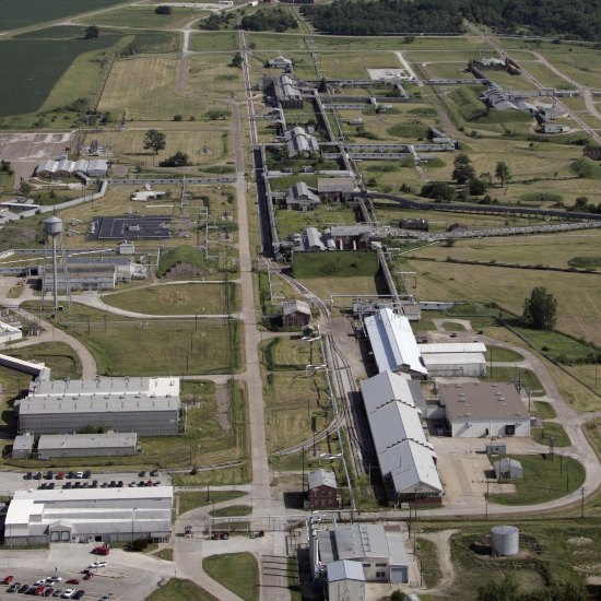
Iowa Army Ammunition Plant
The Iowa Army Ammunition Plant is a government-owned, contractor-operated (American Ordnance) ammunitions production (load, assembly, and pack) facility in southeastern Iowa, approximately four miles west of Burlington. IAAAP encompasses approximately 19,000 acres, including active and inactive production and storage areas, undeveloped areas, and agricultural leases. IAAAP, originally known as Iowa Ordnance Plant, was constructed in November 1940 and began production in 1941. The Atomic Energy Commission operated at portions of IAAAP from 1947 to 1975. Historical operations, by both the Army and AEC, resulted in releases of hazardous substances to soil, surface water, and groundwater at IAAAP. The primary contaminants of concern include explosives, metals, volatile organic compounds, and depleted uranium. The site was added to the National Priorities List in 1990. An initial Interagency Agreement, also known as a Federal Facility Agreement, between the U.S. Army (Army) and the U.S. Environmental Protection Agency was finalized on September 21, 1990. A Subsequent FFA, for areas impacted by AEC operations, was finalized in October 2006. The Federal Facility Agreement for AEC areas at the site is between the U.S. Army Corps of Engineers, the Department of Energy, the state of Iowa, and the EPA.
Remedial activities at IAAAP are being conducted under eight Operable Units: OU-1 (soils), OU-3 (off-post groundwater), OU-4 (inert disposal area), OU-5 (Military Munitions Response Program), OU-6 (on-post groundwater), OU-7 (miscellaneous sites), OU-8 (Formerly Utilized Sites Remedial Action Program), and OU-9 (construction debris sites). Remedial Actions have been, or are being implemented at five of the eight OUs (OU-1, -3, -4, -5, and -8).
On December 4, 2018, EPA approved the Remedial Action Completion Report for OU-4, documenting the successful remedy construction and implementation. This OU encompasses an area of landfills, referred to as the Inert Disposal Area, that received approximately 209,060 cubic yards of contaminated soil generated from remediation activities at other portions of the site. Contaminated soils were transported to the landfills, where they were treated and disposed. LUCs restrict use of approximately 20 acres encompassing and surrounding the landfills. Current activities include periodic groundwater monitoring, operation of the leachate collection system, and LUC inspections.
The following material was removed from Iowa Army Ammunition Plant:
- 200,987 metric tons of soil
- 20 acres of land protected through LUCs
F.E. Warren Air Force Base
F.E. Warren Air Force Base is situated on 5860 acres approximately three miles west of Cheyenne, WY. Multiple historic munitions ranges were utilized within this area from the late 1800s to the late 1900s. The northern portion of the base (approximately 2832 acres), excluding the active ranges, comprise the Closed Ranges. The Closed Firing Ranges have been designated as Operable Unit 7 (OU-7). In 1998, the Closed Ranges at FEW were identified as an Environmental Restoration Program (ERP) site within the Federal Facilities Agreement signed between the United States Air Force and the State of Wyoming Department of Environmental Quality.
Cleanup activities within this area addressed munitions and explosives of concern. Cleanup efforts also addressed the removal of metal debris and fragments from the soil and used a stabilization/solidification process so residual metals would be sufficiently bound and immobilized.
Work on OU-7 yielded the following benefits:
- Addressed 3064 anomalies, 8 MEC, with the remainder safe for offsite disposal
- 315 acres protected through LUCs
Newport Naval Education & Training Center (NETC) Superfund site
The Newport Naval Education & Training Center (NETC) Superfund site was used by the Navy as a refueling depot from 1900 to the mid-1970s. The NETC, currently named Naval Station Newport, encompasses 1,063 acres on the west coast of Aquidneck Island in Portsmouth, Middletown, and Newport, RI. The Base also encompasses the northern third of Gould Island in the Town of Jamestown, RI. The site includes multiple areas of contamination, including one landfill, a fire training area, a former shipyard, five tank farms, and varying degrees of groundwater contamination. The U.S. Navy is the lead agency for site investigation and cleanup, with formal oversight by EPA and the Rhode Island Department of Environmental Management (RIDEM). EPA funded a Technical Assistance Grant to the Eastern Rhode Island Conservation District to provide technical assistance to the community. A federal facility agreement was signed by the Navy, EPA, and RIDEM in March 1992 and it establishes cleanup schedules and enforcement procedures.
There are two Operable Units (OUs) at Site 19, the former Derecktor Shipyard. OU5 deals with marine sediment from this site while OU12 encompasses the onshore area. OU5 was contaminated with lead, PCBs, and benzo(a)pyrene. Remedies at OU5 included testing sediment samples, dredging sediment and offsite disposal to depths of 1-2 feet, and LUCs. An estimated 4,800 people obtain drinking water and 220 acres of land are irrigated from private wells located within three miles of the site. Approximately 10,000 people live within three miles of the site.
The following material was removed from Newport, OU-5:
- 29,011 cubic yards of sediment
- 85 tons of debris
- 72,790 gallons of liquid from dewatering sediment
- 150 acres protected through LUCs
Hanford 100-Area (USDOE) site
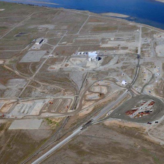
The Hanford 100-Area site is located 35 miles north of Richland, Washington. It is one of four areas at the Hanford Nuclear Reservation originally listed on EPA's National Priorities List. These areas are part of a U.S. Department of Energy complex that includes buildings, disposal sites, contaminated groundwater, a national monument and other vacant land totaling about 580 square miles.
The 100 Area cleanup, also referred to as the River Corridor, is focused on contamination that originated from nine nuclear reactors, the last one shutting down in 1988. Cooling water contaminated with radioactive and hazardous chemicals was discharged to both the adjacent Columbia River and infiltration cribs and trenches. Site operations also included burying contaminated solid wastes on-site. These activities contaminated soil, sludge and groundwater with radioactive constituents, heavy metals and other hazardous chemicals.
The 100 Area is divided into six reactor areas, each with multiple operable units, to better address site contamination. One of the Areas is the 100 D & H Area, where the H, D, and DR Reactors are located. Two of the OUs in the 100 D&H Area are 100-HR-2 and 100-DR-2, OUs 12 & 13, respectively. Remedial actions for 100-HR-2 and 100-DR-2 consisted of excavating contaminated soil, treating if necessary, and disposal at the Environmental Restoration Disposal Facility, the on-site RCRA Subtitle C landfill located in the Central Plateau of the Hanford Site.
The following material was removed from Hanford 100 site:
- OU 12 – 202,235 metric tons of soil
- OU 13 – 1,137,816 metric tons of soil
Dover AFB
The 3,700-acre Dover AFB site in Dover, Delaware, is the base of operation for the 436th Airlift Wing. The base contains 23 areas on site that were used for disposing of industrial waste. An estimated 23,000 cubic feet of waste were disposed of from 1951 to 1970. The base's operations generated numerous wastes, some in drums, including paints, solvents, waste fuels, and oil. These wastes were disposed of in various on-base locations including 12 landfills and three fire training areas. Access to the site is restricted. There are approximately 1,000 people living on base, and 39,000 people living within a three-mile radius of the site. The distance from the base to the nearest residence is a half mile, and the site is located in a commercial and residential area that is densely populated. The base groundwater well system serves about 10,000 people and is routinely monitored by the Air Force. No contaminants have ever been reported in this system.
In September 1995, the Air Force began cleanup operations in the Industrial Area. Contaminant sources in this area include waste treatment units, buildings, hangars, and industrial sewer lines. Also in 1995, the Air Force initiated removal of contamination on the surface of the water table at two former landfills and the recovery of jet fuel on the water table surface at two other locations. A removal action for a portion of a landfill located on a golf course was completed in 1998.
EPA has conducted several five-year reviews of the site’s remedy. These reviews ensure that the remedies put in place protect public health and the environment, and function as intended by site decision documents.
The following material was removed from Dover AFB:
- 11 million gallons of groundwater
Source: Dover OU-9 RA Completion Document