
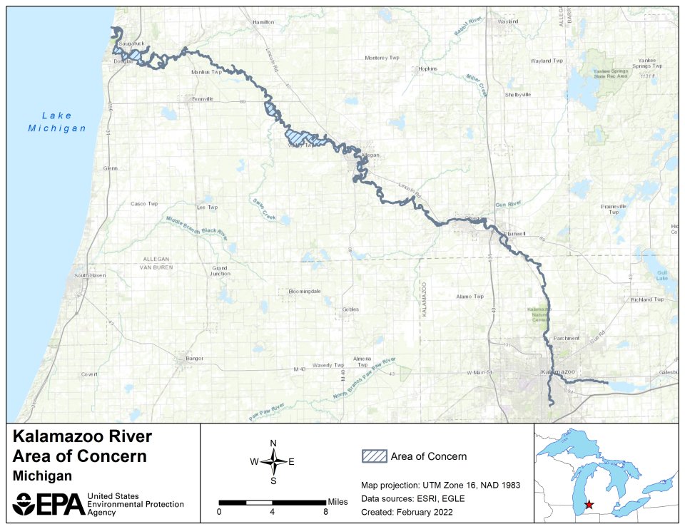
Kalamazoo River AOC

Crawford White
(white.crawford@epa.gov)
312-886-4698
On This Page:
Overview
The Kalamazoo River begins in Hillsdale County as a spring-fed pond and flows 175 miles west, eventually discharging into Lake Michigan near Saugatuck. The river’s watershed drains over 2,000 square miles of land in Michigan’s lower peninsula. The Kalamazoo River AOC includes:
- The lower 80-mile segment of the river from Morrow Dam in Comstock to the river mouth, where it empties into Lake Michigan at Saugatuck
- Three miles of Portage Creek from its confluence with the Kalamazoo River
Historically, the river has been adversely impacted by paper mill industries that utilized the river for their operations. The paper mills discharged polychlorinated biphenyl (PCBs) into the river prior to laws regulating the release of hazardous pollutants. Much of the current sediment contamination in the AOC is associated with PCB waste generated by the paper mills’ de-inking operations. Additionally, dams were built on the Kalamazoo River to support paper mill operations.
The PCBs and dam structures impact the health of the AOC. PCBs persist in river and lake sediments. Because PCBs do not easily break down, they continue to build up, or bioaccumulate, in the tissues of fish and other animals. PCBs also pose health risks to people who frequently eat fish and wildlife that have high tissue concentrations of PCBs. The dam structures limit fish passage in the river and contribute to declining populations. Clean-up of PCB contaminated sediment upstream of each dam must be completed before the dam can be removed to restore fish passage.
Due to the PCB contamination, the river was designated as an Area of Concern under the 1987 Great Lakes Water Quality Agreement. The river has also been identified as a site of environmental contamination under the Michigan Natural Resources and Environmental Protection Act 451 and is a designated Superfund site. Superfund is a federal government program that oversees the cleanup of sites contaminated with hazardous substances.
Beneficial Use Impairments
Up to 14 Beneficial Use Impairments (BUIs) were designated at each AOC by the International Joint Commission (IJC) in 1987. Each BUI represents a distinct type of degradation that is detrimental to environmental and human health. A good indication of successful remediation and restoration work is the removal of BUIs. The Kalamazoo River AOC originally had 8 BUIs, and 2 have since been removed. BUIs can be removed once monitoring has determined that remediation and restoration work has sufficiently improved environmental health according to the standards set by each AOC’s Remedial Action Plan. Once all BUIs in an AOC have been removed, the EPA can begin the process of delisting the AOC.
- Restrictions on Fish and Wildlife Consumption
- Degradation of Fish and Wildlife Populations
- Beach Closings – Removed March 2011
- Degradation of Aesthetics– Removed April 2012
- Bird or Animal Deformities or Reproduction Problems
- Degradation of Benthos
- Restriction on Dredging Activities
- Loss of Fish and Wildlife Habitat
General Information about Beneficial Use Impairments for the Great Lakes AOCs
Remediation and Restoration Work
- Status of the Natural Resource Damage Assessment conducted by the Trustees for the Kalamazoo River Watershed see Kalamazoo River Natural Damage Assessment
- Table of Remediation and Restoration Projects in the Kalamazoo River AOC
- Documents on Restoring Kalamazoo River AOC
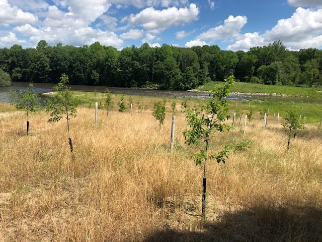
Restoration Project Highlight: Portage Creek Stream and Habitat Restoration
The restoration of Portage Creek, a tributary of the Kalamazoo River, was completed in 2013. Cement walls and steel fixtures ‘hardened’ the shoreline, separating the creek from its natural floodplain. Superfund oversaw the removal of over 23,000 cubic yards of PCB-contaminated sediment and soil from the upland floodplain area of the creek and the AOC program oversaw the habitat restoration efforts.
The AOC program provided $3.3 million in GLRI funds for the project, and local and state sources provided $530,000 in non-federal match to restore Portage Creek. The deteriorating cement channel walls and dangerous piping and steel were removed from the banks of the creek. The creek banks were then returned to a more natural and gently sloping state, and riprap material was added to prevent erosion. Upland floodplain and in-water areas were restored with native vegetation to increase habitat for fish and wildlife populations, as well as bottom-dwelling benthic invertebrates, which are important for the creek’s food web.
For more information on the Portage Creek Stream and Habitat Restoration, see Michigan Areas of Concern: Kalamazoo Project Highlight
The sediment remediation and habitat restoration efforts addressed the BUIs below:
- Restrictions on Fish and Wildlife Consumption
- Degradation of Fish and Wildlife Populations
- Bird or Animal Deformities or Reproduction Problems
- Degradation of Benthos
- Loss of Fish and Wildlife Habitat
Restoration Project Highlight: Otsego Township Dam Spillway Removal and Habitat Restoration
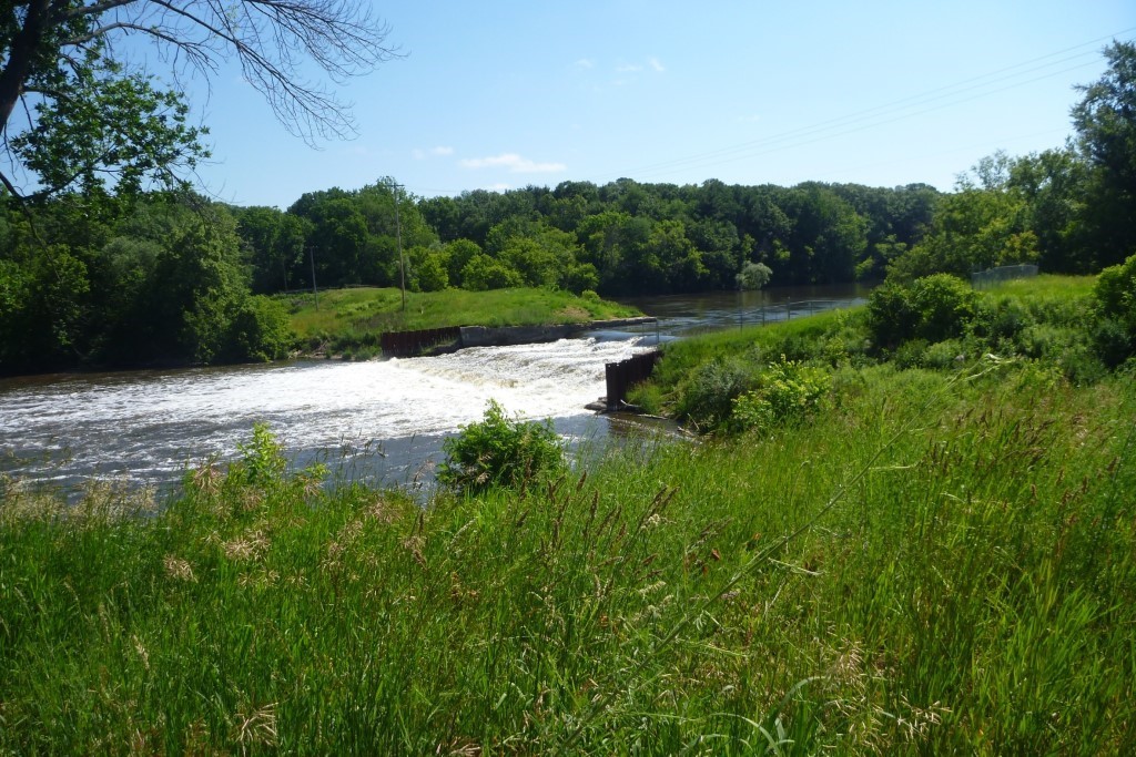
The Otsego Township Dam was built in the early 1900s to provide hydroelectric power to the area. The dam location was chosen on this location of the Kalamazoo River because of its rapid change in streambed elevation. The restriction of free-flowing water resulted in the buildup of PCB-contaminated sediment behind the dam. Prior to its removal, the dam had been deteriorating for years and was categorized as the highest possible risk of failure. In addition to the safety risk the dam posed to anglers and paddlers, if it failed then the accumulated sediment would have washed downstream and contaminated large stretches of the river.
In 2018, Superfund oversaw the remediation of the contaminated sediments in the impoundment above the dam and the demolition of the former dam powerhouse area. The AOC program then provided GLRI funds to remove the spillway and restore floodplain habitat.
Following the removal of the dam powerhouse area and spillway, the river was routed back to its original channel and the stream banks were stabilized. The floodplain was also restored at the spillway site and provides habitat for native wildlife and plant species. The restoration of free-flowing water provides vital feeding and spawning habitat for fish in the area. It also allows for healthy sediment and nutrient transport, which helps mussel populations thrive.
The project increased the recreational value and safety of the river. Increased fish habitat provides better opportunities for anglers, and the removal of the dam in the steep-sloped section of the river provides fun and challenging rapids for paddlers.
The sediment remediation, dam removal and floodplain restoration addressed the BUIs below:
- Restrictions on Fish and Wildlife Consumption
- Degradation of Fish and Wildlife Populations
- Bird or Animal Deformities or Reproduction Problems
- Degradation of Benthos
- Loss of Fish and Wildlife Habitat