
Remediation and Restoration Projects for Detroit River AOC
On this page:
- Lake Okonoka Habitat Restoration Project
- Celeron Island
- The Detroit Riverwalk
- Table of Remediation and Restoration Projects
Remediation and Restoration Project Highlights
Lake Okonoka
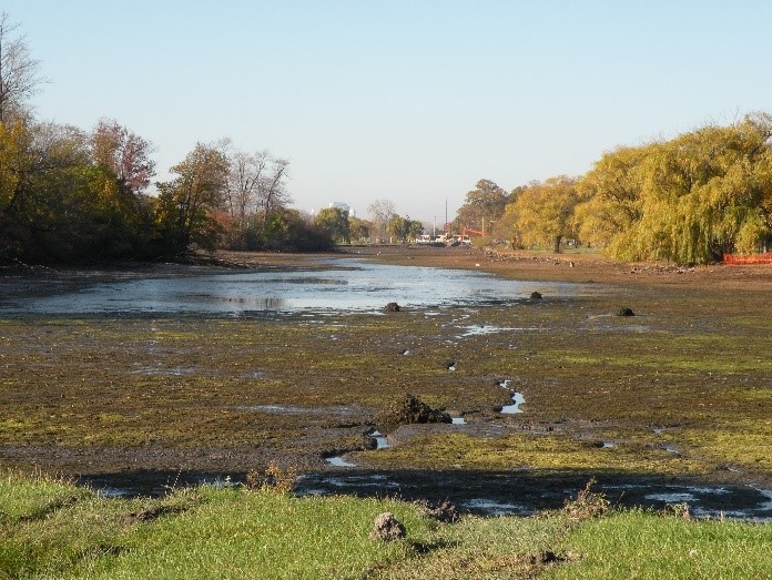
Lake Okonoka is located on Belle Isle, an island in the Detroit River. In the 1950s, the lake was disconnected from the Detroit River, preventing Great Lakes fish from utilizing the lake for habitat. In 2014, a partnership between the Friends of the Detroit River, National Oceanic and Atmospheric Administration and Michigan Department of Natural Resources began designing the project to reconnect Lake Okonoka and the Detroit River by installing culverts and channels.
The project included the replacement of a stop-log weir at the north end of Lake Okonoka with a road bridge. This connects Lake Okonoka with the Blue Heron Lagoon, creating free passage of Great Lakes water and fish.
The project incorporated 3,800 linear feet of deep channeling, 3.2 acres of deep-water pools, 0.18 acres of gravel substrate to provide fish spawning beds, 1.5 acres of mudflats providing foraging opportunities for shorebirds and 2 acres of wet meadow for pollinators and amphibian passage between the flatwoods forest and lake.
The Lake Okonoka Habitat Restoration project was a collaborative effort among many project partners that included a $70,000 local match of funds for design. Construction began in August 2017 and was completed in 2020.
Celeron Island
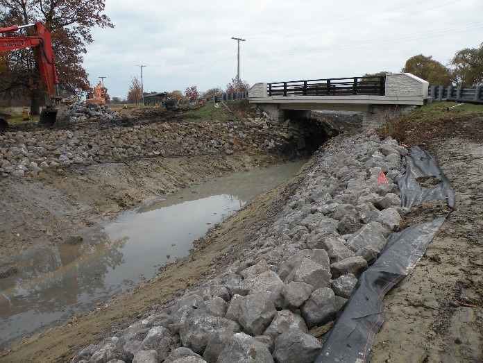
A barge places rocks along a berm constructed to reduce erosion and provide additional spawning habitat within the Detroit RI AOC. Photo Credit: Friends of the Detroit River
Celeron Island is 68 acres of uninhabited forests and wetlands, located at the south end of the Detroit River and is near the end of the Detroit River AOC boundary. The Celeron Island Habitat Restoration project included the construction of off-shore emergent shoals at the south end of the island. These rock shoals enhanced critical fish spawning habitat as well as stopover habitat for waterfowl. The project is part of a larger effort to address erosion issues on the southern end of the island and restore remnant habitat.
The project started in 2018 and finished at the end of 2019. The project created nearly 4,000 linear feet of shoals, incorporating multiple niche habitats including shallow water habitat, a depression of spawning habitat area, barrier beach, rock piles, basking logs and woody debris bundles. This will benefit multiple species including waterfowl, shorebirds, mudpuppies, turtles, and fish. The emergent shoals will provide protection against future erosion events and allow for regeneration of the island’s outer shoreline emergent vegetation.
The Detroit Riverwalk Great Lakes Legacy Act Cleanup
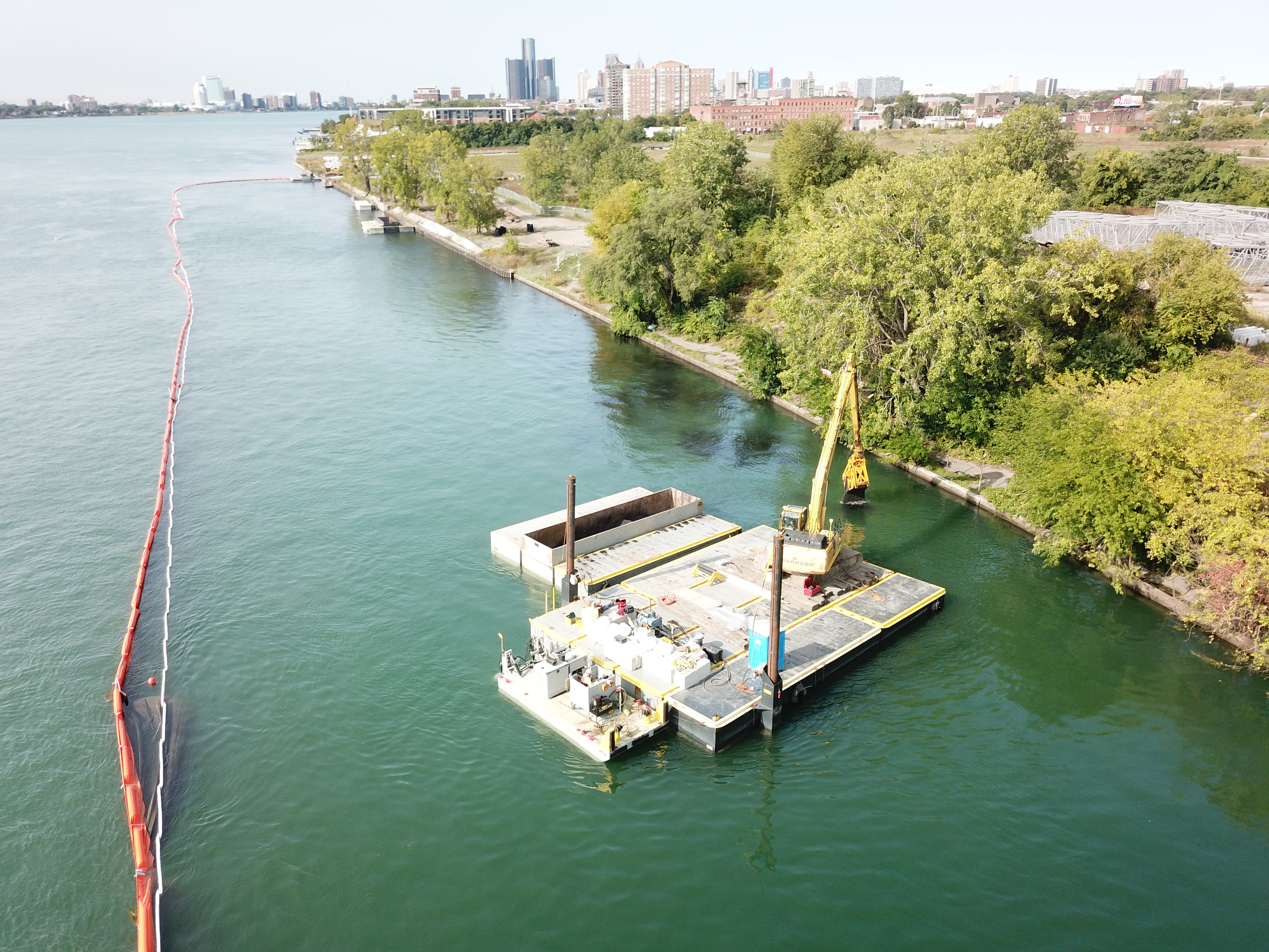
EPA and non-federal sponsor, Detroit Riverfront Conservancy, addressed contaminated sediments from a 1.2-acre site in the Detroit River upstream of downtown Detroit in 2020. The Detroit Riverwalk project resulted in the remediation of about 13,000 cubic yards of contaminated sediment. Remaining sediment was capped in place to isolate contaminants from the water which eliminated exposure to contaminants.
The $2.9 million sediment clean up allowed for an expansion of the Detroit Riverwalk which is considered one of the best river walks in the United States.
Project Table
| Project Title | Project Description | Date Completed | Targeted BUI(s) |
|---|---|---|---|
| Upper Riverfront Parks Habitat | This project involves improving and restoring approximately 1,000 ft of shoreline with native wetland edge and fish spawning habitat; establishment/enhancement of upland native vegetation for birds, mammals, and pollinator species; and the creation of approximately 7 acres of aquatic habitats. | Ongoing |
|
| Monguagon Creek GLLA | The project will result in the remediation of contaminated sediments (petroleum compounds, PAHs, PCBs and heavy metals (mercury)) in Monguagon Creek and downstream in the Detroit River. | Ongoing |
|
| Upper Trenton Channel Project | Sediment remedial feasibility study, design and partnership recruitment is on-going at the Upper Trenton Channel in the Detroit River to remediate sediment contaminated with PAHs, PCBs, mercury, and high pH. | Ongoing |
|
| Harbortown and Harbortown Upstream Feasibility Study and Remedial Design | This Feasibility Study and Remedial Design will evaluate existing data from previous investigations to develop remedial alternatives and use the selected alternative to develop a remedial design for future implementation to address contaminated sediments. | Ongoing |
|
| Riverbend Remedial Investigation | This remedial investigation will cover approximately 3.4 miles from Huntington Place Convention Center to the North side of Zug Island. This investigation will further define contaminated areas along the Riverbend shoreline for future remediation actions. | 2026 (est.) |
|
| Rouge River-Ecorse Shoreline Remedial Investigation | This remedial investigation will cover approximately 3 miles of the Detroit River from the Rouge River Cut Off Channel to Ecorse Creek. This investigation will further define contaminated areas along the Rouge River-Ecorse shoreline for future remediation actions. | 2026 (est.) |
|
| Elizabeth Parks Canals Remedial Investigation | This remedial investigation will cover the 1.5 miles within Elizabeth Park Canals. This investigation will further define contaminated areas along the canal shoreline for future remediation actions. The portion of the Elizabeth Park Canals Target Area between George Street and the canal is planned to be addressed as a separate remediation effort by the EPA Superfund Emergency Management Division. | 2026 (est.) |
|
| Gibraltar Canals Remedial Investigation | The remedial investigation will cover the approximate 2.0-miles of shoreline within the Gibraltar Canal system. This investigation will further define contaminated areas within the canal system for future remediation actions. | 2026 (est.) |
|
| Sugar Island | This project aims to stabilize and restore 1,000 linear feet of coastal shoreline to help protect the island from severe erosion and create 5 acres of marsh and submergent habitat to benefit both aquatic and terrestrial species. | 2024 |
|
| Harbortown Remedial Investigation | This remedial investigation will cover approximately 2 miles of the Detroit River from the MacArthur Bridge at Belle Isle to the Renaissance Center in downtown Detroit. This investigation will further define contaminated areas along the Harbortown shoreline for future remediation actions. | 2024 |
|
| Ralph C. Wilson Centennial Park | This Project consists of capping approx. 3.8 acres of contaminated sediments. There is also a significant habitat restoration component consisting of a Water Garden, soften shoreline and a fish reef. PAHs are the main contaminant of concern. | 2024 |
|
| Hennepin Marsh | Plans call for rebuilding existing shoals to stabilize the area, such as installing submergent and emergent woody debris, stone spawning beds, stone habitat structures, and a tern habitat shoal. | 2023 |
|
| Belle Isle Forested Wetland Restoration | This project aims to restore surface water flow patterns critical to the flatwoods by removing former roads and trails, conserving special species of concern, and re-establish native vegetation. | 2023 |
|
| Detroit River Walk GLLA | This remediation project addressed 13,000 yd3 of PAH, cyanide, mercury, and lead contaminated sediments. | 2020 |
|
| Stony Island | This project created 3,500 linear feet of rock shoals, 600 linear feet of vegetated shoal and installed roughly 100 new habitat structures that provide homes for fish, turtles, snakes, amphibians, and birds. | 2018 |
|
| Detroit River Fish Spawning Reefs: Belle Isle reef; Grassy Island reef; and Ft. Wayne reef | This project constructed three four-acre fish spawning reefs in the Detroit AOC. The Belle reef off the NW side of Belle Isle was completed in 2016. The reefs off Grassy Island and Ft. Wayne were established in 2018. | 2016; 2018 |
|
| Harbortown Sediment Site Characterization | This sediment site characterization included approximately 2 miles of the Detroit River from the MacArthur Bridge at Belle Isle to the Renaissance Center in downtown Detroit. | 2016 |
|
| Mid-lower Trenton Channel Sediment Site Characterization | This sediment site characterization included the Detroit River from the Grosse Ile toll bridge to the south end of Calf Island. | 2015 |
|
| River Rouge/Ecorse Sediment Site Characterization | This sediment site characterization included approximately 3 miles of the Detroit River from the Rouge River Cut Off Channel to Ecorse Creek. | 2014 |
|
| South Fishing Pier | Three breakwater barriers and three rock underwater berms were built to protect the newly created aquatic fish nursery habitat. The nursery consists of three 0.2-acre deep pools. | 2013 |
|
| Blue Heron Lagoon Restoration | This project connected the lagoon to the Detroit River to provide a zooplankton-rich nursery for fish larvae to thrive. A 0.5-acre peninsula of wet prairie, two vernal pools, and a turtle nesting area were also constructed. | 2013 |
|
| USS Shoreline Project | This project restored upland and shoreline habitat along 1,000 feet of Detroit River along the US Steel 80” mill property and created habitat for reptiles and amphibians. | 2013 |
|
| Shoreline Restoration at Wayne County's Refuge Gateway | This project restored 28 acres of wetland, controlled phragmites along 2.5 miles of shoreline, restored 25 acres of upland buffer habitat, and controlled invasive species on 50 acres of upland habitat. | 2013 |
|
| Celeron Island Sediment Site Characterization | This sediment site characterization included the Detroit River around Horse and Celeron Islands, in the vicinity of Gibraltar, MI. | 2013 |
|