
Detroit River AOC
Amber Falkner
(falkner.amber@epa.gov)
312-886-0217
On this page:
Overview
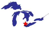
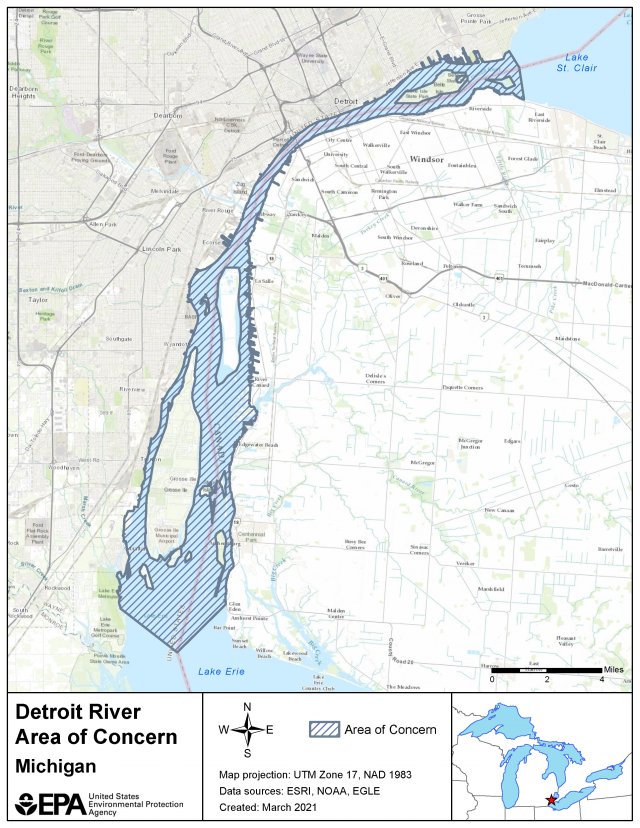
The Detroit River Area of Concern is one of five binational AOCs shared between the United States and Canada. It drains an area of land in Michigan and Ontario that is approximately 700 square miles.
There are five Michigan tributaries to the Detroit River, one is the Rouge River AOC. Three additional tributaries drain from the Ontario portion of the watershed. Lake St. Clair and two additional AOCs, the Clinton River AOC and the St. Clair River AOC, are immediately upstream of the Detroit River.
Historically, the Detroit River has been a source of water for various industries and has experienced rapid residential development within its watershed. For decades, the river received untreated waste discharges from industrial use, and inputs from urban development and stormwater runoff, which degraded the river. These pollution sources have contributed to high levels of bacteria, Polychlorinated biphenyls (PCBs), polycyclic aromatic hydrocarbons (PAHs), metals, oils, and greases within the AOC.
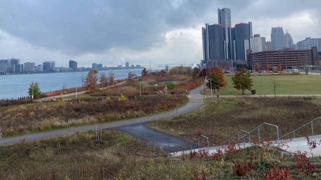
The Detroit River AOC has the largest city in the state of Michigan along its shoreline. Fortunately, concerted efforts to address combined sewer and sanitary sewer overflows, nonpoint source pollution, contaminated sediment, habitat restoration and pollution prevention are leading to continued improvement within the AOC. This webpage only covers the United States’ side of the Detroit AOC. For information about Canadian efforts in the AOC, please visit Detroit River Canadian Cleanup.
Beneficial Use Impairments
Remediation and restoration work is conducted with the ultimate goal of delisting an AOC. The interim success of that work is removing beneficial use impairments. Beneficial use impairments are designations given by the International Joint Commission representing different types of significant environmental degradation. As cleanup work completed, and monitoring demonstrates sufficient environmental health improvements, BUIs can be removed. The list below shows which BUIs have been removed in the Detroit River AOC, and which remain. Once all BUIs are removed, the process of delisting the AOC can begin.
- Tainting of Fish and Wildlife Flavor (pdf) (1.73 MB) – Removed August 2013
- Restrictions on Drinking Water Consumption or Taste and Odor (pdf) (598 KB) – Removed July 2011
- Restrictions on Fish and Wildlife Consumption
- Degradation of Fish and Wildlife Populations
- Beach Closings
- Fish Tumors or Other Deformities
- Degradation of Aesthetics
- Bird or Animal Deformities or Reproduction Problems
- Degradation of Benthos
- Restriction on Dredging Activities
- Loss of Fish and Wildlife Habitat
More information:
- General information about BUIs: Beneficial Use Impairments for the Great Lakes AOCs
Remediation and Restoration Work
The Detroit River AOC has many partners working together to address the existing beneficial use impairments. Efforts towards contaminated sediment remediation and habitat restoration have made significant progress, but there is still work to do.
We've completed two Great Lakes Legacy Act sediment contamination cleanups within the Detroit River AOC, the Black Lagoon project and Detroit Riverwalk project. There are three active remediation projects: Upper Trenton Channel remediation, the Monguagon Creek – Upper Trenton Channel remediation, and Centennial Park Shoreline remediation and habitat restoration. Sampling results indicate that several additional Legacy Act projects will be needed in the future.
Highlighted below are examples of restoration and remediation projects that are necessary to remove the Detroit River AOC’s BUIs. Friends of the Detroit River created a story map of different projects in the Detroit River AOC.
-
Completed Project Highlights
Remediation and restoration accomplishments.
-
Table of Projects
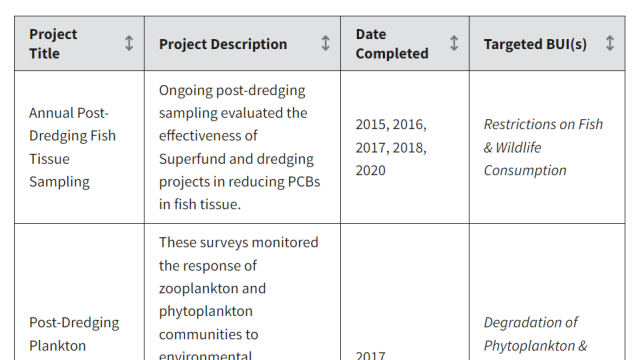
Remediation and restoration project table.
-
Restoration Documents
Remediation and restoration documents.

Remediation Project Highlight: Monguagon Creek – Upper Trenton Channel Final Design and Upcoming Remedial Action
EPA and non-federal sponsor Bridgestone Americas Tire Operations, LLC (BATO) completed a final remedial design to address contaminated sediments in the lower 800 feet of Monguagon Creek and 1,000 linear feet and two acres of the Upper Trenton Channel, immediately downstream of the Grosse Ile Toll Bridge. Monguagon Creek flows into the Trenton Channel in Riverview, just south of Bridge Road and the Grosse Ile Toll Bridge. The final remedial design will include shoreline stabilization and mechanical removal of approximately 28,000 cubic yards of polyaromatic hydrocarbons (PAHs), petroleum compounds, and heavy metals contaminated sediment. The upcoming Remedial Action is planned to be completed in 2027. This action follows the 1997 Monguagon Creek remediation of 35,000 tons of contaminated sediment upstream of the MCUTC project area.
Completion of this remedial action contributed to the removal of the following BUIs:
- Degradation of fish and wildlife habitat
- Degradation of fish and wildlife populations
- Fish Tumors and Other Deformities
- Degradation of Benthos
Additional sediment remediation actions are necessary within the Detroit River AOC to fully address these BUIs.
Remediation Project Highlight: Detroit River Area of Concern Remedial Investigations
EPA in coordination with Michigan Department of Environment, Great Lakes, and Energy (EGLE) have been working towards defining “known contamination sites” throughout the Detroit River Area of Concern. Since 2012, we've completed multiple site characterizations and remedial investigations into the Detroit River. Findings of the investigations lead us to establish the following target areas within the AOC:
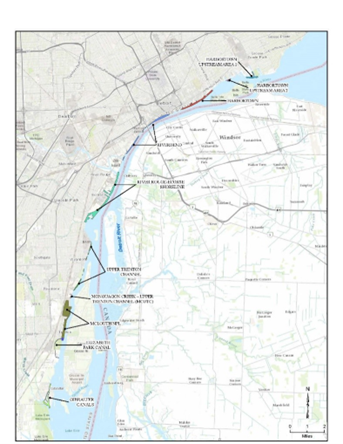
- Harbortown Upstream Shoreline
- Harbortown Shoreline
- Riverbend Shoreline
- River Rouge-Ecorse Shoreline
- Trenton Channel
- Elizabeth Park Canals
- Gibraltar Canals
Five additional remedial investigations are scheduled to be completed in 2026. Remedial investigations for Harbortown Shoreline and Riverbend Shoreline were completed in fall 2024. Remedial investigations for River Rouge-Ecorse Shoreline, Elizabeth Park Canals, and Gibraltar Canals were completed in spring 2025. Once the final Remedial Investigation reports are completed, the Detroit River AOC will be primed to move into Feasibility Study phase once a Great Lakes Legacy Act project partner is secured.
These investigations will help us determine the full nature and extent of shoreline contamination, the main contaminants of concern and possible source areas, and better estimate of the volume of contaminated sediment in each target area.
Remediation Project Highlight: Ralph C. Wilson Jr. Centennial Park Sediment Remediation and Habitat Restoration
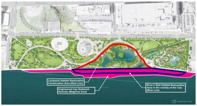
EPA and non-federal sponsor, Detroit Riverfront Conservancy (DRFC), developed a joint remedial design project to renovate Wilson Park, a 22-acre park located in the Corktown neighborhood of Detroit, Michigan. Using Great Lakes Legacy Act funds, the goal of the project is to remediate 30,000 cubic yards (approximately 3.8 acres) of contaminated sediment and restore valuable aquatic habitat within the Detroit River. The Wilson Park site is located at the western end of the 5-mile-long Detroit River Riverwalk.
The sediment remediation project will include: (1) placing an engineered cap along a 2,100-foot stretch of the Detroit River adjacent to the park, (2) replacing the failing shoreline with a soft shoreline to stabilize the edge of the park and prevent any subsidence into the river, (3) placing spawning reefs in the Detroit River, and (4) constructing a 1.35-acre water garden with connected wetlands surrounded by an additional 2.75 acres of native vegetated habitat. Construction for the sediment remediation portion of the project is expected to be completed in winter 2023.
Completion of the joint project will contribute to the removal of the following BUIs:
- Degradation of Benthos
- Fish Tumors or Other Deformities
- Bird or Animal Deformities or Reproduction Problems
- Restrictions on Fish and Wildlife Consumption
- Degradation of Fish and Wildlife Populations
- Loss of Fish Habitat
Remediation Project Highlight: Monguagon Creek Great Lakes Legacy Act Remedial Design
EPA and non-federal sponsor Bridgestone Americas Tire Operations, LLC (BATO) are developing a remedial design plan to address contaminated sediments in the lower 1,700 feet of Monguagon Creek and approximately 50 acres of the Trenton Channel. Monguagon Creek flows into the Trenton Channel in Riverview, just south of Bridge Road and the Grosse Ile Toll Bridge. The cleanup design is expected to be completed in 2024, with remediation to potentially follow in 2025. Read the Monguagon Creek Community Involvement Plan (pdf)
Completion of this remedial action contributed to the removal of the following BUIs:
- Restrictions on Dredging Activities
- Fish Tumors and Other Deformities
- Degradation of Benthos
Additional sediment remediation actions are necessary to fully address these BUIs.
Partners
- Detroit River Canadian Cleanup
- Friends of the Detroit River
- Michigan Department of Environment, Great Lakes and Energy
- Michigan Sea Grant
- Ontario Ministry of the Environment