U.S. flag

An official website of the United States government

Here’s how you know

Dot gov

Official websites use .gov
A .gov website belongs to an official government organization in the United States.

HTTPS

Secure .gov websites use HTTPS
A lock (LockA locked padlock) or https:// means you’ve safely connected to the .gov website. Share sensitive information only on official, secure websites.

    • Environmental Topics
    • Air
    • Bed Bugs
    • Cancer
    • Chemicals, Toxics, and Pesticide
    • Emergency Response
    • Environmental Information by Location
    • Health
    • Land, Waste, and Cleanup
    • Lead
    • Mold
    • Radon
    • Research
    • Science Topics
    • Water Topics
    • A-Z Topic Index
    • Laws & Regulations
    • By Business Sector
    • By Topic
    • Compliance
    • Enforcement
    • Laws and Executive Orders
    • Regulations
    • Report a Violation
    • Environmental Violations
    • Fraud, Waste or Abuse
    • About EPA
    • Our Mission and What We Do
    • Headquarters Offices
    • Regional Offices
    • Labs and Research Centers
    • Planning, Budget, and Results
    • Organization Chart
    • EPA History

Breadcrumb

  1. Home
  2. Global Change Explorer (GCX)

ICLUS Data for the Southeast Region (V.1)

  • Northwest
  • Southwest
  • Great Plains
  • Midwest
  • Northeast
  • Southeast
Southeast Region
Map showing just the Southeast Region of the United States
The Southeast region includes AL, AR, FL, GA, KY, LA, MS, NC, SC, TN, and VA.

ICLUS data made available to the Regional groups of the National Climate Assessment consists of population and housing density. Population data are based on the 2000 U.S. Census and use fertility rates from the Census Bureau to project population to 2100 in 5-year time steps for each county in the conterminous United States. By using high and low fertility rates, scenarios are consistent with A2 and B1 scenarios, respectively. The population data are used as inputs to a spatial allocation model, which produces maps of housing density. These data are classified into four categories of urban, suburban, exurban, and rural. The resolution of these data is 1 hectare.

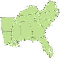
Datasets available here cover the Southeast region. All data are compatible with standard Geographic Information Systems (GIS).

Dataset to download Description Metadata
Population Data (A2 & B1 files) 1.3 MB, Shapefile format County Population Projections
A2 Housing Density Data 189 MB, GRID format Housing Density Projections (Classified)
B1 Housing Density Data 191 MB, GRID format Housing Density Projections (Classified)

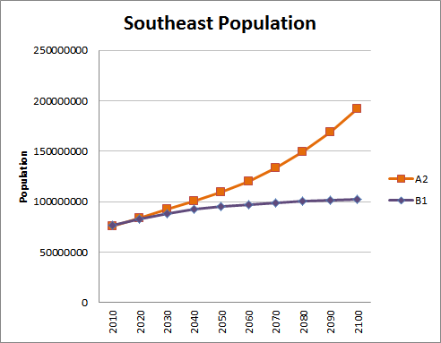
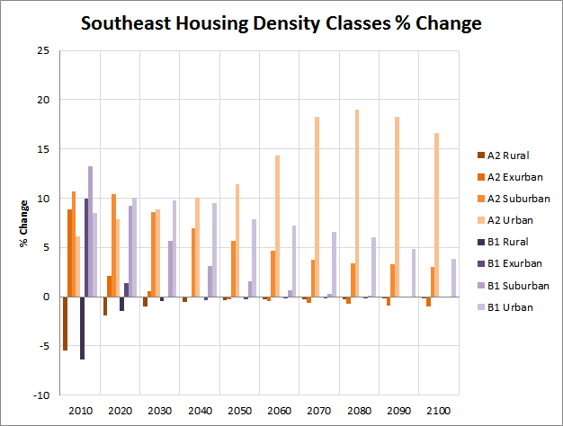
The graphs below provide an overview of population and housing density trends across the two scenarios, A2 and B1, over time for the Southeast region.

Chart showing the growth of the southeast population.
Download Population Trend Data using ICLUS Version 1 Datasets (xls) (1 pg, 87 K, 01/31/2012)
Chart showing the Southeast Population Housing Density Trends
Download Housing Density Trends By Region (xls) (1 pg, 144 K, 01/31/2012)

Additional Information about ICLUS

Detailed documentation of the ICLUS project is available: the land-use scenarios report includes examples of modeling methods, a GIS tool, and the full datasets for the conterminous United States, as well as additional scenarios.

  • Learn more about the Land-Use Scenarios Report at  Land-Use Scenarios: National-Scale Housing-Density Scenarios Consistent with Climate Change Storylines (Final Report)
  • Learn more about the GIS tool and datasets at ICLUS Tools and Datasets (Version 1.3 & 1.3.1) 

Global Change Explorer (GCX)

  • Critical Loads
  • Ecosystem Management
    • Adaptation Design for Coral Reef Restoration
    • Adaptation Design Tool
    • Delaware Bay Wetland Projections
  • Integrated Land Use
    • 4th National Climate Assessments
    • ICLUS Downloads
  • Location Scenarios
  • Resilience
  • Watersheds
Contact Us about GCX
Contact Us to ask a question, provide feedback, or report a problem.
Last updated on January 18, 2025
  • Assistance
  • Spanish
  • Arabic
  • Chinese (simplified)
  • Chinese (traditional)
  • French
  • Haitian Creole
  • Korean
  • Portuguese
  • Russian
  • Tagalog
  • Vietnamese
United States Environmental Protection Agency

Discover.

  • Accessibility Statement
  • Budget & Performance
  • Contracting
  • EPA www Web Snapshot
  • Grants
  • No FEAR Act Data
  • Plain Writing
  • Privacy
  • Privacy and Security Notice

Connect.

  • Data
  • Inspector General
  • Jobs
  • Newsroom
  • Regulations.gov
  • Subscribe
  • USA.gov
  • White House

Ask.

  • Contact EPA
  • EPA Disclaimers
  • Hotlines
  • FOIA Requests
  • Frequent Questions
  • Site Feedback

Follow.