U.S. flag

An official website of the United States government

Here’s how you know

Dot gov

Official websites use .gov
A .gov website belongs to an official government organization in the United States.

HTTPS

Secure .gov websites use HTTPS
A lock (LockA locked padlock) or https:// means you’ve safely connected to the .gov website. Share sensitive information only on official, secure websites.

    • Environmental Topics
    • Air
    • Bed Bugs
    • Cancer
    • Chemicals, Toxics, and Pesticide
    • Emergency Response
    • Environmental Information by Location
    • Health
    • Land, Waste, and Cleanup
    • Lead
    • Mold
    • Radon
    • Research
    • Science Topics
    • Water Topics
    • A-Z Topic Index
    • Laws & Regulations
    • By Business Sector
    • By Topic
    • Compliance
    • Enforcement
    • Laws and Executive Orders
    • Regulations
    • Report a Violation
    • Environmental Violations
    • Fraud, Waste or Abuse
    • About EPA
    • Our Mission and What We Do
    • Headquarters Offices
    • Regional Offices
    • Labs and Research Centers
    • Planning, Budget, and Results
    • Organization Chart
    • EPA History

Breadcrumb

  1. Home
  2. EPA in Missouri

EPA Adds St. Louis Environmental Data to EnviroAtlas Online

– EPA Region 7 Feature –

Environmental data for the St. Louis area is now available on EPA’s interactive, web-based tool called EnviroAtlas, which contains data and maps for 48 states and 1,400 cities and towns.

EnviroAtlas logo
States, communities and the public can use EnviroAtlas to help inform policy and planning decisions that impact the places where people live, learn, work and play.

The fine-scale data available at the urban/community level can be used to inform decisions related to comprehensive urban planning, transportation, children’s health, green infrastructure, parks, greenways and more.  

EnviroAtlas combines maps, analysis tools, fact sheets, and downloadable data into an easy-to-use, web-based resource that allows users to understand the implications of various planning decisions and analyze relationships between nature, health and well-being, and the economy. The tool includes data for towns and cities ranging in population from 1,500 to 9.8 million and from exurban to fully urbanized communities.
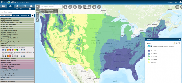
EnviroAtlas map screen shot
Urban areas featured in EnviroAtlas are selected based on environmental and human health data availability, population size, geography and regional interest.

All EnviroAtlas data layers are available via a mobile-friendly, web-based, interactive mapping application that does not require additional software or specialized skills to use.

  • Learn more about EnviroAtlas
  • Learn more about the new St. Louis data
Contact Us to ask a question, provide feedback, or report a problem.
Last updated on December 20, 2024
  • Assistance
  • Spanish
  • Arabic
  • Chinese (simplified)
  • Chinese (traditional)
  • French
  • Haitian Creole
  • Korean
  • Portuguese
  • Russian
  • Tagalog
  • Vietnamese
United States Environmental Protection Agency

Discover.

  • Accessibility Statement
  • Budget & Performance
  • Contracting
  • EPA www Web Snapshot
  • Grants
  • No FEAR Act Data
  • Plain Writing
  • Privacy
  • Privacy and Security Notice

Connect.

  • Data
  • Inspector General
  • Jobs
  • Newsroom
  • Regulations.gov
  • Subscribe
  • USA.gov
  • White House

Ask.

  • Contact EPA
  • EPA Disclaimers
  • Hotlines
  • FOIA Requests
  • Frequent Questions
  • Site Feedback

Follow.