Map Design & Cartography at the EPA
Introduction
Analysts at the Environmental Protection Agency apply their expertise in geographic information systems (GIS), data science, and cartography to protect human health and the environment. Geospatial data and map products provide locational insights into EPA programs and support Agency operations nationwide. Among their many applications, both geospatial data and map products help the Agency gauge environmental risks, enforce federal regulations, and address potential homeland security issues.
In this way, thoughtfully designed maps are key for communicating EPA’s impact to its stakeholders. In 2023, the Office of Finace and Administration developed this cartographic guidance to provide a unified, recognizable, and professional visual identity to EPA’s various map products, agnostic of the software or service used. The effort also attempted to maximize map interpretation and design best practices to ensure that Agency maps, and the data they display can be used and understood by Agency stakeholders.
Color Palette
This color palette was compiled by the Office of Finance and Administration in collaboration with the EPA Geospatial Advisory Committee. Its style draws from EPA-branded media, including the Agency Seal and Logo, as well as the EPA Web Style Guide. The EPA Web Style Guide includes colors from the U.S. Web Design Standard as well. Access more information on these Web Design Standards. In this way, the palette provides consistent identity recognition, while offering a wide variety of color options. Associated color ramps have been tested for digital accessibility in terms of color-blindness on grayscale basemaps.
Please note that it remains a best practice to use the Color Contrast Analyzer, WAVE extension for Google Chrome, and/or other color-blindness simulators to ensure best practices are met. Though the palettes and ramps provided have been tested for color-blind considerations, novel ramps designed using these colors may not be or meet color-contrast specifications (Ratio of 4.5:1). Moreover, these colors and their associated ramps have not been evaluated by Pantone, Inc. for accuracy and may not match the Pantone Color Standards. Please contact the Office of Finance and Administration or the National Geospatial Support Team for more information.
Click Here to Download Excel File
Click Here to Download ArcPro Style File
Typography
Using common typefaces in communication materials further enhances an organization’s identity. The following clean, sophisticated, and versatile typefaces are to be used for our print and online outputs. For the web maps and related applications, analysts are recommended to use fonts associated with the Federal Web Style Guide, which was adopted by the EPA Web Design Standard. Access more information about preferred serif and sans serif fonts. Preferred Serif fonts include Merriweather Web, Georgia, Cambria, and Times New Roman. Preferred Sans Serif fonts include Source Sans Pro, Helvetica Neue, Roboto and Arial.
EPA Logo & Seal
The EPA logo is the primary graphic symbol that should be used on all maps and related applications, either public-facing or internal. The EPA seal is reserved for official communication for the Administrator’s Office, legal and ceremonial use, speaker podiums, awards and plaques, videos and in conjunction with other agency seals on print documents. The Agency does not permit any other logos or symbols to be used on these products, unless otherwise approved by a Region’s or Program Office Public Affairs official.
Access Color Palettes in ArcGIS Pro
Adding the EPA style to your project can be accomplished in these steps:
On the ribbon select the Insert tab. Then select styles and add file.
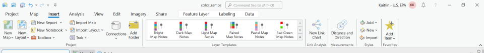
- The add a style file box will open. On the left hand side navigate to the my organization content underneath portal.
- Select (Insert name of file).
- Once added you can now access the color ramps. The style file can additionally be found within the catalog pane under the styles option.
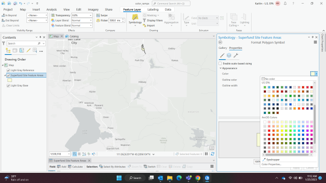
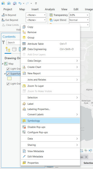
Adding an EPA Approved Color to a Symbol
Right click on the desired layer and select symbology
- Within the symbology pane under primary symbology select the dropdown and find Single Symbol.
Depending on your data this type will be changed!
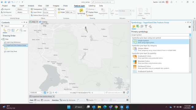
- Double chick the colored box to the right of symbol. This will open the color properties.
Lastly, select the dropdown to the right of the colored box and scroll down to (LAYER NAME). You have now accessed the EPA approved colors.