U.S. flag

An official website of the United States government

Here’s how you know

Dot gov

Official websites use .gov
A .gov website belongs to an official government organization in the United States.

HTTPS

Secure .gov websites use HTTPS
A lock (LockA locked padlock) or https:// means you’ve safely connected to the .gov website. Share sensitive information only on official, secure websites.

    • Environmental Topics
    • Air
    • Bed Bugs
    • Cancer
    • Chemicals, Toxics, and Pesticide
    • Emergency Response
    • Environmental Information by Location
    • Health
    • Land, Waste, and Cleanup
    • Lead
    • Mold
    • Radon
    • Research
    • Science Topics
    • Water Topics
    • A-Z Topic Index
    • Laws & Regulations
    • By Business Sector
    • By Topic
    • Compliance
    • Enforcement
    • Laws and Executive Orders
    • Regulations
    • Report a Violation
    • Environmental Violations
    • Fraud, Waste or Abuse
    • About EPA
    • Our Mission and What We Do
    • Headquarters Offices
    • Regional Offices
    • Labs and Research Centers
    • Planning, Budget, and Results
    • Organization Chart
    • EPA History

Breadcrumb

  1. Home
  2. Geospatial Resources at EPA

EPA Geospatial Applications

EPA has developed many applications that allow users to explore and interact with geospatial data. This page highlights some of the flagship geospatial web applications but these represent only a fraction of the total. We recommend Data.gov as the best tool to help connect you with an application that best meets your needs.

Air Quality Tools:

  • Clean Air Status & Trends Network (CASTNET)

    National monitoring network established to assess trends and changes to air pollutant emissions. 

    Explore
  • AirNow

    Provides current, historical and forecast air quality maps and data across the U.S., Canada and Mexico using the Air Quality Index (AQI).

    Explore
  • Air Quality Data

    Provides access to outdoor air quality data collected from state, local, and tribal monitoring agencies across the U.S.

    Explore

Water Quality Tools:

  • Water Data & Tools

    water

    Helps EPA protect and restore our waters to ensure that they are drinkable, fishable, and swimmable.

    Explore
  • How's My Waterway

    water

    Communicates information about the conditions of local waters based on data that states, federal, tribal, local agencies, and others have provided to EPA.

    Explore

Waste Management Tools:

  • Cleanups In My Community (CIMC)

    Construction vehicles at a work site

    Used to map and list areas where pollution is being or has been cleaned up throughout the United States.

    Explore
  • Disaster Debris Recovery Tool (DDRT)

    Construction vehicles at a work site

    Interactive mapping tool of twelve types of recyclers and landfills that can manage disaster debris.

    Explore
  • Excess Food Opportunities Map

    This is a picture of a pile of food waste

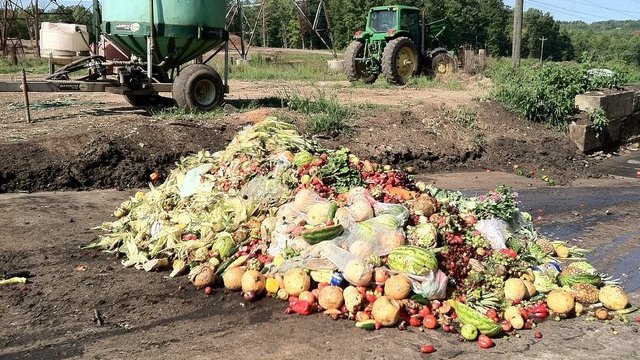
    Learn about potential sources of excess food in your region and potential non-landfill recipients.

    Explore

Learn about your Environment:

  • Climate Resilience Evaluation & Awareness Tool (CREAT)

    Climate Change

    Creates scenario based climate projections. Users consider climate impacts and identify adaptation options to increase resilience. 

    Explore
  • MyEnvironment

    stream

    Web-based tool that features a wide range of information about environmental conditions in an area of your choice. 

    Explore
  • EnviroAtlas

    stream

    Provides geospatial data, easy-to-use tools, and other resources related to ecosystem services, their stressors, and human health.

    Explore
  • Smart Location Mapping

    Is a nationwide geographic data resource for measuring location efficiency. Includes attributes summarizing characteristics such as housing density, diversity of land use, neighborhood design, destination accessibility, transit service, employment, and demographics. 

    Explore
  • NEPAssist

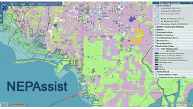
    Tool that facilitates the environmental review process and project planning in relation to environmental considerations.

    Explore

Other:

  • Facility Registry Service (FRS)

    placeholder

    Identifies facilities, sites or places subject to environmental regulations or locations that represent an environmental interest.

    Explore
  • EPA Metadata Editor (EME)

    Custom software tool that aids the practical documentation of geospatial datasets. 

    Explore
  • Envirofacts Data Warehouse

    stream

    Allows users to learn about environmental activities in their area or generate maps of environmental information.

    Explore
  • Enforcement & Compliance History Online (ECHO)

    stream

    Provides integrated compliance and enforcement information for more that one million regulated facilities nationwide. 

    Explore

Geospatial Resources at EPA

  • About EPA's Geospatial Program
  • EPA Geospatial Data
  • EPA Geospatial Applications
  • Geospatial Policies and Standards
  • Federal Geospatial Resources
  • EPA’s Unmanned Aircraft Systems (UAS)
Contact Us About Geospatial Resources at EPA
Contact Us to ask a question, provide feedback, or report a problem.
Last updated on February 27, 2025
  • Assistance
  • Spanish
  • Arabic
  • Chinese (simplified)
  • Chinese (traditional)
  • French
  • Haitian Creole
  • Korean
  • Portuguese
  • Russian
  • Tagalog
  • Vietnamese
United States Environmental Protection Agency

Discover.

  • Accessibility Statement
  • Budget & Performance
  • Contracting
  • EPA www Web Snapshot
  • Grants
  • No FEAR Act Data
  • Plain Writing
  • Privacy
  • Privacy and Security Notice

Connect.

  • Data
  • Inspector General
  • Jobs
  • Newsroom
  • Regulations.gov
  • Subscribe
  • USA.gov
  • White House

Ask.

  • Contact EPA
  • EPA Disclaimers
  • Hotlines
  • FOIA Requests
  • Frequent Questions
  • Site Feedback

Follow.