Example - Cold Water Fish
Step 1 Set Goal & Scope
The goals listed in the U.S. Environmental Protection Agency's (U.S. EPA) Columbia River Cold Water Refuges (CWR) Plan are to:
- Identify the cold-water refuges currently available for migrating salmon.
- Assess the sufficiency of the refuges for current and future populations.
- Identify strategies to restore, enhance, and protect high-quality refuges for the future.
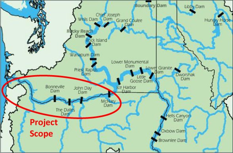
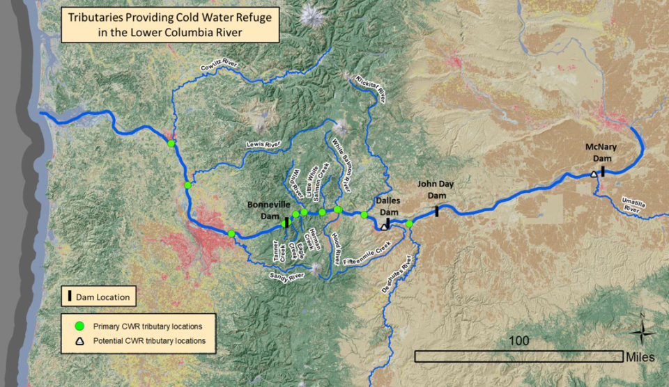
The geographic scope was set for the Columbia River CWR Plan as the Lower Columbia River from the mouth to the confluence of the Snake River, which is near the Oregon-Washington border (Figure 1).
The overarching goal driving the development of the Columbia River CWR Plan was to support the U.S. EPA's Endangered Species Act consultation with the National Oceanic and Atmospheric Administration on the U.S. EPA's approval of Oregon's temperature quality standards for the protection of endangered migrating salmon and steelhead. Both numeric temperature criteria and the role of CWR in protecting these species from adverse impacts during summer migrations are described in Oregon's standards.
Step 2 Assess Threats & Vulnerabilities
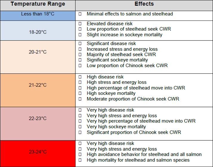
The Columbia River Cold Water Refuges (CWR) Plan describes two levels of threats/vulnerabilities. One is the exposure of migrating salmon and steelhead trout to water temperatures above 20°C, which causes increased stress, disease, death, and energy loss, potentially reducing spawning success (Figure 2). This information supports the goal of approving and complying with Oregon’s numeric and narrative temperature criteria, which rely on CWR to mitigate exposures of endangered salmon and steelhead to higher river temperatures during summer migrations.
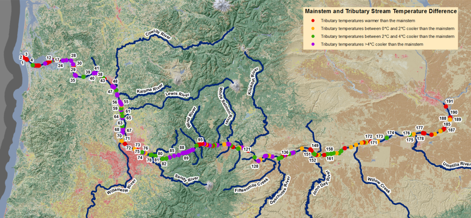
The second vulnerability is that of CWR to thermal changes and watershed changes. The plan details spatial and temporal variations in exposures to temperatures exceeding the defined 20°C threshold. This includes an analysis of historic river temperatures, future projections due to large-scale environmental changes, and summaries of salmon and steelhead sensitivities to incremental temperature increases over the 20°C threshold. Also evaluated are temperature differences between CWR and the main river (Figure 3), as the magnitudes of these differences dictate the functional value of CWR to salmon and steelhead.
Other threats evaluated included fish harvesting from CWR. The U.S. Environmental Protection Agency used a fish behavior simulation model to simulate behavior and movement and track thermal exposure of individual fish migrating through the Lower Columbia River, using results to estimate the sufficiency of existing CWR for migrating salmon and steelhead. More research is needed to accurately separate reduced survival due to temperature impacts versus harvest impacts.
Step 3 Identify, Evaluate & Prioritize Site(s)
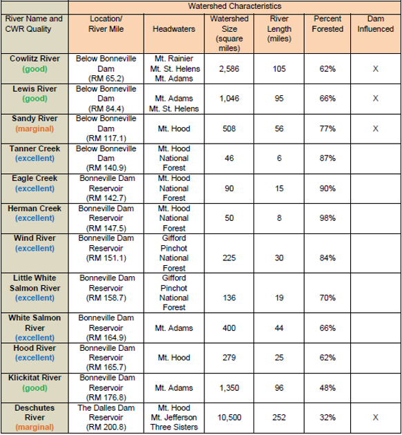
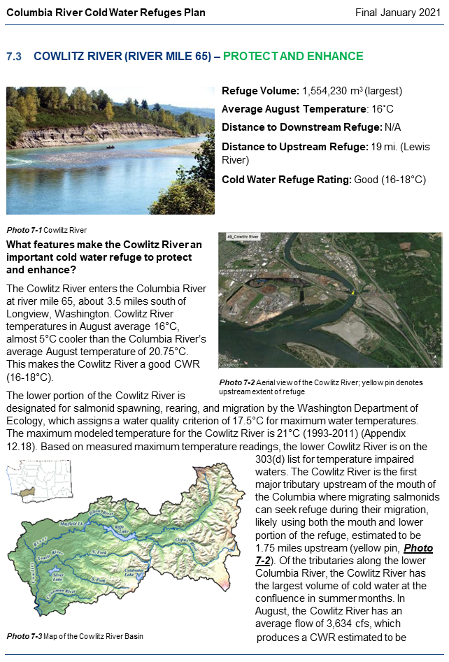
The Columbia River Cold Water Refuges (CWR) Plan identified 23 tributaries in the lower Columbia River as potential CWR sites. Each tributary was evaluated to assess its volume, temperature, accessibility and use by migrating adult salmon and steelhead trout.
Due to current and potential future impairment of CWR functions resulting from environmental change-related increases in water temperatures, 14 CWR sites were prioritized for site-specific protection and/or restoration. Of those, 12 "primary" CWR sites (Figure 4; green dots) were identified based on their current capacity to provide CWR areas. Two additional CWR sites (Figure 4; white triangles) that do not currently provide primary CWR function were prioritized for their restoration potential to provide additional CWR areas in the future.
Step 4 Identify, Design & Select Interventions
Interventions identified to protect existing Cold Water Refuges (CWR) focused on avoiding human actions that could increase CWR temperatures and restoring CWR to cool temperatures to counteract projected warming from large-scale environmental change (Figure 5). For each CWR site, watershed features were identified that either contributed to or degraded their quality, and interventions were designed to protect or restore those features accordingly (in particular, to maintain or reduce temperatures and offset future warming.
Selected protection and restoration interventions designed for each lower Columbia River CWR site are considered regulatory, related to existing management, or voluntary. Choosing and implementing them requires finding agencies and organizations with jurisdiction over actions that will guide the work of local stakeholders and regional planning groups, as well as actions with multiple benefits (e.g., for salmon recovery or existing watershed management).
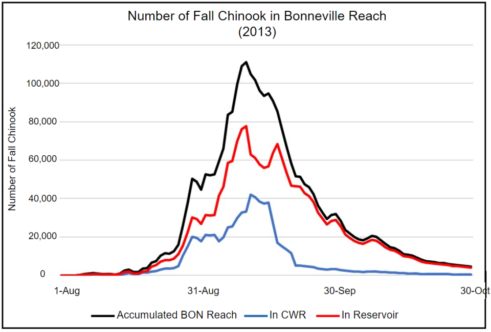
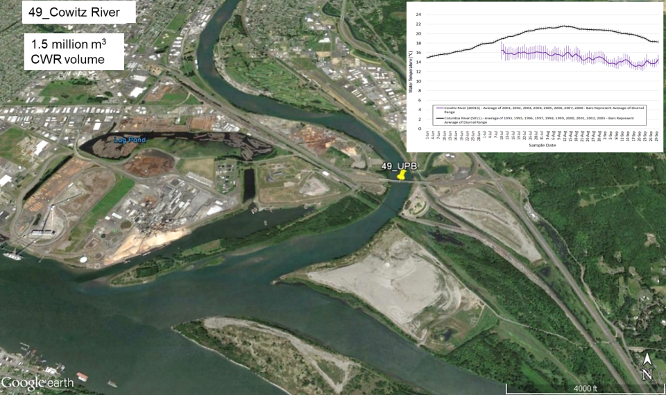
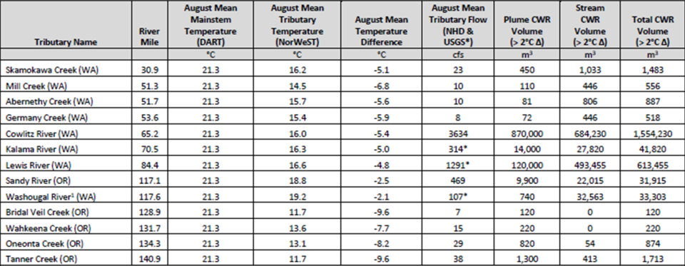
The watershed analyses for each CWR included information on temperatures, the upstream extent of fish use, documented fish use by migrating salmonids (Figure 6), flows and plume volumes (Figure 7), maps of geography, geology, and land use/cover, land ownership, riparian cover, water allocation, and activities in each watershed, as well as existing sub-basin plans, regional salmon recovery plans and local watershed priority plans.
Step 5 Assemble Objectives, Targets & Action Plan
The U.S. Environmental Protection Agency (U.S. EPA) team assembled a regional Action Plan (Figure 8) for protecting and restoring Cold Water Refuges (CWRs) for salmon and other fish species in the Columbia River. This plan represents a comprehensive summary of the outputs of planning steps one through four.
The Plan:
- Defines management objectives for each CWR site identified in step 3, making the objectives as SMART (specific, measurable, attainable, realistic, and time-bound) as possible.
- Recommends protection and restoration activities for each CWR that are realistic management targets for implementation.
- Supplements the management recommendations with a summary of information on uncertainties and additional research needs.

To make it easier to access and understand the extensive technical background information developed as part of the Columbia River CWR Plan, the U.S. EPA planning team developed a set of 'CWR watershed snapshots' (Figure 9) showing results for the 12 primary and two secondary CWR sites as a separate chapter in the action plan. The snapshots summarize the conditions of the CWRs, features of their watersheds that are key to maintaining or degrading CWR quality and are the basis for the recommended protection or restoration actions, and other existing local planning and management activities (e.g., sub-basin plans, regional salmon recovery plans, local watershed priority plans). Where possible, these snapshots also identify agencies and organizations that have jurisdictional authority over the recommended actions, making it easier for the planning team to 'hand-off' to these local partners for implementation.
Step 6 Implement Interventions & Monitoring
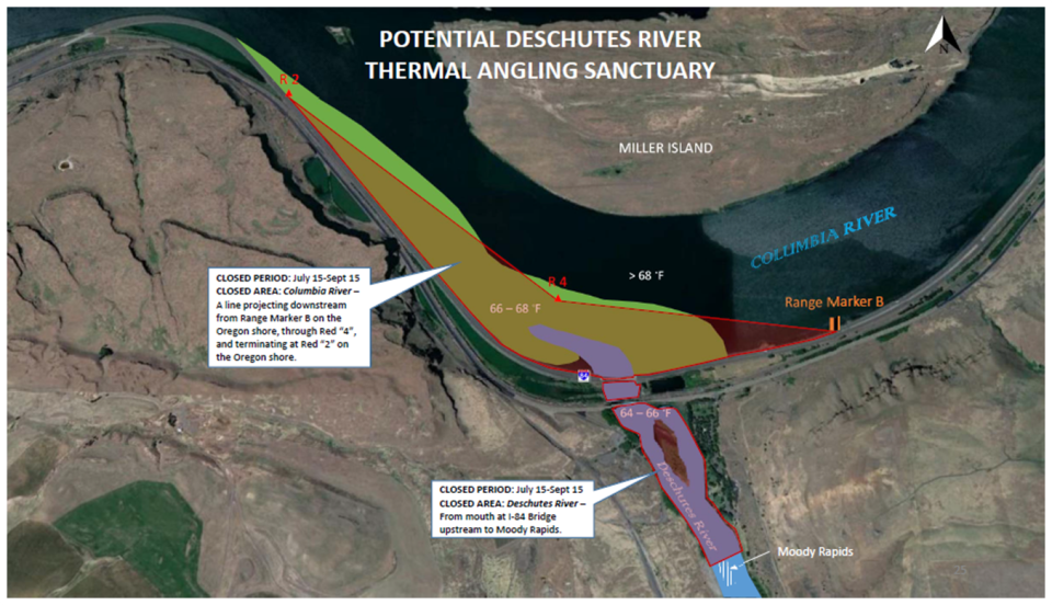
As an intervention to protect Columbia River Cold Water refuges, The Oregon Fish and Wildlife Commission implemented a regulatory intervention -- temporary rules ongoing since the 2020 fishing season -- that limits angling for steelhead in thermal sanctuaries at the mouths of Herman Creek, Eagle Creek, and the Deschutes River (Figure 10). Future monitoring will be needed to detect any positive effect on fish populations.
Step 7 Document Progress & Evaluate Success
The Columbia River Cold Water Refuges Plan recommends that refugia be adaptively monitored to document progress and evaluate success in terms of their effectiveness, with the potential to realign locations and management practices accordingly.
The plan also recommends monitoring flow and water temperature (Figure 11) as part of intervention efforts.