
Regional Monitoring Networks - Wetlands
Wetland RMNs
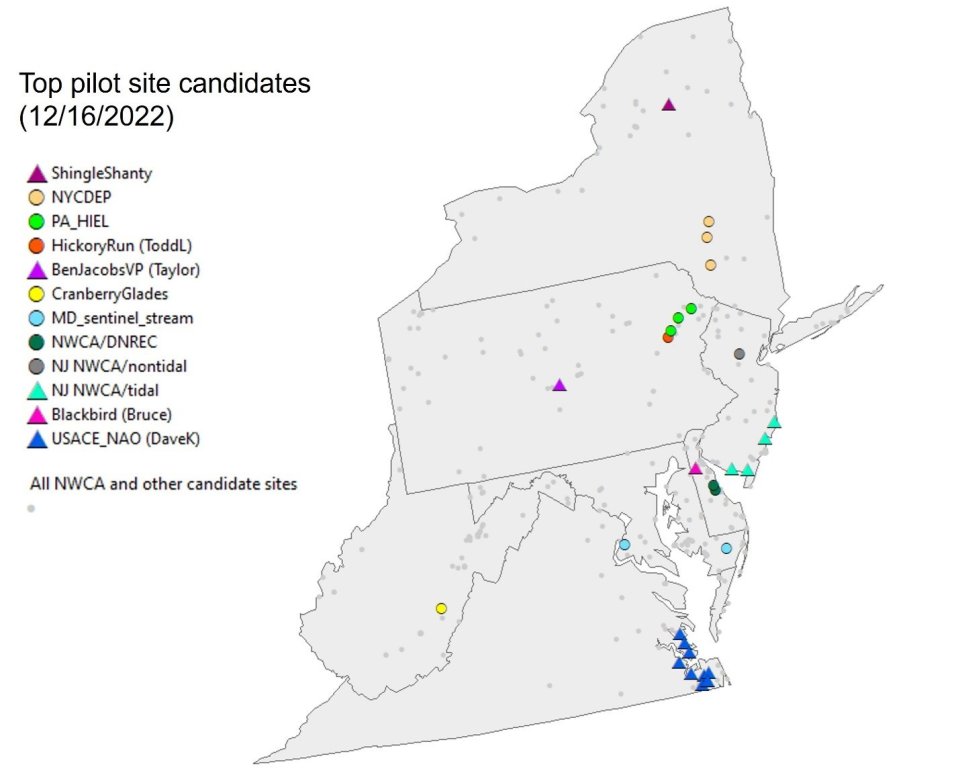
EPA is currently working with its regional offices, states, tribes, and other entities to establish Regional Monitoring Networks (RMNs) for wetlands. Current efforts focus on the Mid-Atlantic and can expand into other regions. Figure 1 shows the current proposed Wetland RMN sites.
Building the capacity of states, tribes, and other entities to assess the biological, chemical, and physical integrity of wetlands is an EPA National Wetlands Program priority. A National Wetland Monitoring and Assessment Workgroup was established in 1999. The Mid-Atlantic Wetland Monitoring and Assessment Work Group (MAWWG) is a subgroup of the national effort and assisted with starting the first wetland RMNs.
Wetland RMN monitoring includes both freshwater and tidal wetland locations. For tidal wetlands, The Virginia Institute for Marine Science, Delaware Department of Natural Resources and Environmental Control, and Maryland Department of Natural Resources have been working together on development of a multi-level (Level I, Level II and Level III) tidal wetland inventory and assessment methodology for the Delmarva peninsula (Delaware, Maryland and Virginia).
Efforts to date related to monitoring both freshwater and tidal wetlands are several:
- Landscape level delineation of wetlands, which can be viewed for Virginia using the Wetland Condition Assessment Tool (WetCAT)
- “Nanticoke River Watershed Wetland Study” in the Chesapeake Bay watershed.
- The “Mid-Atlantic Tidal Wetland Rapid Assessment Method (PDF)(40 pp, 2.3M , About PDF).
Other sates contributing to the Mid-Atlantic wetlands monitoring efforts include Pennsylvania, West Virginia, New York, North Carolina, and Ohio. The Chesapeake Bay Program Office is another partner.
Part of wetland monitoring that will be unique is measuring the areal (spatial) extent of wetland areas in watersheds that are subject to different hydrogeological patterns. Wetland vegetation can be diagnostic of the areas that can be classified as wetlands.
In addition to the RMN data uses described on the About page, Wetland RMN data Uuses include:
- Determining the capacity of wetlands to buffer nutrient and pesticide runoff from agricultural areas
- Tracking primary productivity of wetlands and suitability as carbon sinks
- Understanding the role of wetlands are ‘nurseries’ for fisheries
Importantly, the data will allow tracking of decoupling of hydrologic conditions and plant community composition through time, an outcome that is missed when a site is only sampled once as part of a larger survey.
Wetland protocols
Wetland RMN sites use consistent sampling methods to the extent feasible. Some measures and indicators, however, will be unique to wetlands, specifically for different types of soil hydrology and vegetation. Similar to stream and lake RMNs, participants can collect data at different levels of effort based on available resources.
Wetland RMN sites with active data collection deploy a variety of equipment, including wells and barometer, and time-lapse cameras. Time-lapse cameras capture changes in water level and vegetation parameters, such as invasive species encroachment and spring leaf out.
Sampling protocols to monitor wetland vegetation, soil condition, and hydrology continue to be refined as more sites join. Indicators of particular interest to partners include timing of seasonal inundation, soil organic matter, and plant species composition.
Wetland site selection criteria
Wetland RMNs leverage existing wetland monitoring locations and current wetland mapping efforts where feasible. General characteristics for selecting locations for primary and secondary wetland RMN sites are similar to those for streams and lakes. Site selection uses the wetlands classification from EPA’s National Aquatic Resource Surveys. Additional characteristics to consider include areas that are along hydrogeological gradients and near the center and edges of important wetlands. Wetland monitoring locations may extended into floodplains at strategic locations.
Detailed site screening criteria are under development for the Wetlands RMNs. Table 1 lists desired characteristics of candidate sites that will be used in the screening process.
Table 1. Main site selection considerations.
Consideration | Desired characteristics at wetland RMN sites |
|---|---|
Existing monitoring network | Located in established monitoring network(s). Sites with lengthy historical sampling records are preferred. |
Disturbance | Low level of anthropogenic disturbance is preferred (but is not required)
|
Potential for future disturbance | Wetlands that are protected from future development are preferred. |
Accessibility | Able to make multiple site visits per year to download camera images and water level sensor data. Main considerations include travel distance for field crews and ease of access. Potential hurdles include: field crews needing to carry heavy equipment over long distances, needing to obtain special permits for each visit, needing to borrow a special boat (or other equipment) to access the site, or not being able access the site certain times of the year due to hunting or other restrictions. |
Equipment | Co-locating with existing equipment where feasible. If sites do not have existing sensors, consider their suitability for installation of new wells. Considerations include level of human and bear activity (the less likely the chance of vandalism, the better) and ground heaving during freeze/thaw cycles. Proximity to weather stations, USGS surface water gages, ground water wells, and stream and lake RMN sites are pluses. |
Shared workload | Opportunities to partner with outside agencies or organizations. Need hydrology, soil, and botany experts to advise on the sampling plan/layout of survey plots and assist with surveys as needed. |
Significance | Some sites are highly valued for ecological or cultural reasons (e.g., exemplary biodiversity, presence of threatened and endangered (T&E) species). |
Managing both discrete and continuous data collected from RMN sites is similar across the different types of RMNs and is described on a separate Data Management page. The Data Analysis page describes how RMN data are analyzed, summarized, and visualized to explore a variety of endpoints.