
Superfund Sites in Reuse in Massachusetts
If you are having trouble viewing the map in your browser, click the 'View larger map' link below
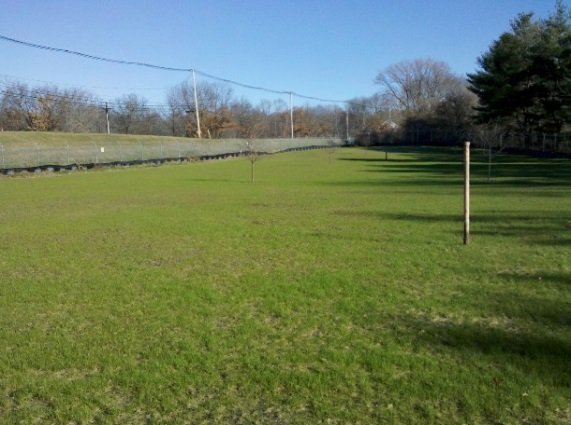
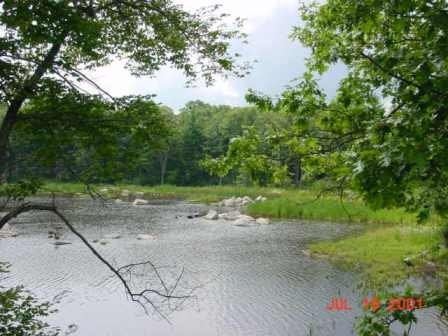
31 WATER STREET
The half-acre 31 Water Street site is located next to the Back and Powwow rivers in Amesbury, Massachusetts. Several industrial operations in the Lower Millyard contaminated site soils and surrounding surface waters. The city of Amesbury discovered the contamination during initial revitalization efforts for the historic Amesbury Wharf building area, where the site is located. The EPA’s Superfund removal program committed $1.2 million to remove contaminated soil from the site and stabilize the riverbanks. The EPA dug up 1,400 tons of contaminated soil and disposed of it off site. The EPA also stabilized the riverbanks with 400 feet of sheet pile wall. The EPA completed cleanup actions in July 2015. The site, part of the community’s Lower Millyard Project, is now home to Heritage Park. Funding from the commonwealth of Massachusetts and the EPA’s Superfund removal program facilitated the site’s cleanup and redevelopment. The park provides residents and visitors with a recreation resource next to the Powwow River. A bandstand and river walk will soon be added to the park. The Amesbury Riverwalk, a 1.3-mile walking and biking trail, runs next to the site. At a ceremony marking the completion of the Lower Millyard Project, Amesbury’s mayor issued a proclamation thanking the EPA for its assistance.
Last updated September 2024
As of December 2025, EPA did not have economic data related to on-site businesses, or economic data were not applicable due to site use. For additional information click here.
For more information:
ATLAS TACK CORP.
The Atlas Tack Corp. Superfund site is in Fairhaven, Massachusetts. It covers about 48 acres and includes upland areas, wetlands and saltwater marsh. From 1901 to 1985, the Atlas Tack facility made a variety of metal products, including tacks and steel nails, on-site. Operations released waste containing acids, metals, and solvents into drains and an unlined lagoon near a marsh area. Waste disposal practices resulted in contamination of soil, surface water, sediment and groundwater. In 1990, the EPA added the site to the National Priorities List (NPL). Cleanup activities included demolition of most remaining site structures, removal of contaminated soil, groundwater monitoring and site restoration. The EPA completed these activities in 2007; monitoring began in 2008. Restored wetlands and the saltwater marsh now provide habitat for plants, fish and wildlife. Birders frequent the area for bird-watching activities. These citizen scientists have recorded several species on-site, including the Pie-billed Grebe, the American Bittern and the Least Bittern, which are endangered in Massachusetts. The EPA’s Superfund Redevelopment Program (SRP) began supporting a regional seed project in 2023 to assist with the preparation of interpretive signage graphics that could help tell the story of Superfund cleanup and natural resources restoration work at the site. Potential future development at the site could include commercial and industrial reuse of upland areas.
Last updated September 2024
As of December 2025, EPA did not have economic data related to on-site businesses, or economic data were not applicable due to site use. For additional information click here.
For more information:
BENDIX PROPERTY (FORMER)

The 17.5-acre Former Bendix Property site is located in Greenfield, Massachusetts. A metalworking facility that made drill bits, taps and dies was located on site. A 94,000-square-foot, single-story building sat vacant for about 10 years and deteriorated. Openings in the roof allowed in rain and snow. The rain and snow damaged the heat and water piping, which was wrapped with asbestos-containing insulation wrap. Chromium-containing powder was present in and around the building. The EPA removed contaminated materials and devices as well as chromium- containing powder, capacitors and contaminated water, and transported them to approved facilities. A metal tank and bin production company from Holyoke, Massachusetts, is interested in buying the site property to enlarge its operations.
Last updated September 2024
As of December 2025, EPA did not have economic data related to on-site businesses, or economic data were not applicable due to site use. For additional information click here.
For more information:
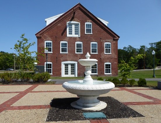
BLACKBURN & UNION PRIVILEGES
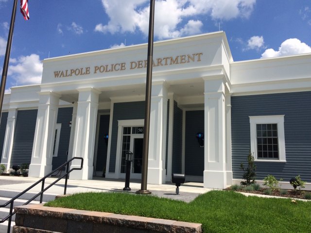
The Blackburn & Union Privileges Superfund site is in Walpole, Massachusetts. Industrial and commercial processes using chromium, arsenic and mercury in the area date back to the 1600s. Between 1891 and 1915, manufacturing of tires, rubber goods and insulating materials took place on-site. The crushing of raw asbestos in the manufacture of brake and clutch linings occurred at the site from 1915 to 1937. Cotton and fabric production took place at the site from 1937 to 1985, when the facility was abandoned. Industrial operations contaminated soil, sediment and groundwater. The EPA added the site to the NPL in 1994. In 1999, the EPA entered into a settlement with parties for the site’s remedial investigation and feasibility study. In 2000, the EPA awarded the town of Walpole a Superfund Redevelopment Program pilot grant to develop reuse plans for the property. The EPA approved the site’s cleanup plan in 2008. It divided the site into four management units requiring excavation and dredging with off-site disposal of contaminated soil and sediment, extraction and treatment of contaminated groundwater, and institutional controls and long-term monitoring. In 2010, the EPA entered into a settlement with the parties to design and perform the cleanup. Remedy construction began in 2015. The town took over site parcels for unpaid taxes and developed a new police station and senior center on-site. In May 2018, town officials, police and community members gathered to attend a ribbon-cutting ceremony to open a new police station. In December 2018, another ribbon-cutting ceremony marked the completion of a new senior center – the Walpole Co-operative Bank South Street Center. Continued site uses include a residential area and a community rail trail for recreation.
Last updated September 2024
As of December 2025, EPA had data on 3 on-site businesses. These businesses employed 66 people and generated an estimated $1,874,750 in annual sales revenue. For additional information click here.
For more information:
- Blackburn & Union Privileges Superfund Site - Before and After
- Reuse and the Benefit to Community: A Beneficial Effects Economic Case Study for the Blackburn & Union Privileges Superfund Site (PDF)
- Region 1 Excellence in Site Reuse Award: Blackburn & Union Privileges Site
- Superfund Site Profile Page
Video: EPA Superfund Redevelopment 20th Anniversary
CANNON ENGINEERING CORP. (CEC)
The 7-acre Cannon Engineering Corp. (CEC) Superfund site is in Bridgewater, Massachusetts. Beginning in the 1970s, CEC transported, stored and burned hazardous wastes at the site. Mishandling of the waste and reporting violations led to the facility closing in 1980. In 1982, the Massachusetts Department of Environmental Protection (MassDEP) removed contaminated sludge and drums from the site. The EPA added the site to the National Priorities List (NPL) in 1983. Cleanup included installation of fencing, soil treatment of lesser-contaminated soils, excavation and off-site disposal of highly contaminated soils, groundwater monitoring, decontamination and removal of contaminated buildings and structures, restoration of wetlands, and institutional controls. In the mid-1990s, Osterman Propane Distribution (Osterman) relocated to the former CEC facility. It operates at the site through a Prospective Purchaser Agreement (PPA). A PPA encourages the reuse of Superfund site properties by addressing purchaser and lessee liability concerns. In 1998, Omnipoint Communications Enterprises began leasing property (on another parcel of land that is part of the site) and built a cellular communication tower. The responsible parties completed the cleanup in 2013. The EPA took the site off the NPL in September 2013. The EPA continues to monitor the site, conducting Five Year Reviews of the cleanup actions, every five years to make sure the remedies continue to remain protective of human health and the environment.
Last updated September 2024
As of December 2025, EPA had data on one on-site business. This business employed 9 people and generated an estimated $62,704,000 in annual sales revenue. For additional information click here.
For more information:
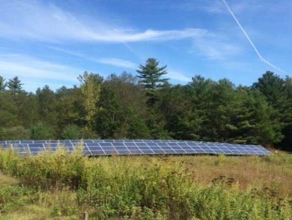
CHARLES GEORGE RECLAMATION TRUST LANDFILL
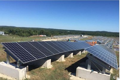
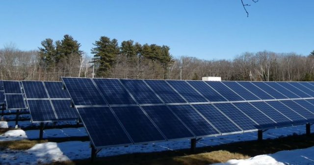
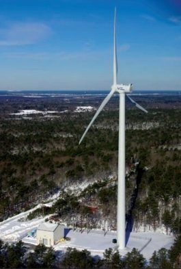
The 70-acre Charles George Reclamation Trust Landfill Superfund site is in Tyngsborough, Massachusetts. Initially a small municipal dump, the landfill expanded to accept household and industrial wastes, chemicals containing volatile organic compounds and metal sludge. The commonwealth ordered the landfill closed in 1983. Site operations contaminated groundwater. The EPA added the site to the National Priorities List (NPL) in 1983. Cleanup activities included providing a permanent water supply to residents affected by contaminated groundwater, capping the landfill, and collecting contaminated liquid draining from the landfill (leachate), groundwater and landfill gas. The Massachusetts Department of Environmental Protection operates the landfill gas collection/destruction system and the groundwater/leachate collection system and maintains the cap. The EPA’s Superfund Redevelopment Program and Region 1 did an assessment in 2010 to evaluate opportunities for using Superfund sites in Massachusetts for solar energy. In 2016, Citizens Energy Corporation completed the construction of a 3.56-megawatt solar photovoltaic facility on the landfill.
Last updated September 2024
As of December 2025, EPA had data on one on-site business. EPA did not have further economic details related to this business. For additional information click here.
For more information:
CONWAY PARK
The 2.8-acre Conway Park Superfund site is in Somerville, Massachusetts. From the early 1800s to the 1930s, a bleachery and dye-works factory were on-site. The city of Somerville acquired the property in 1937. A park has been on-site since the 1950s. In 2017, sampling found widespread polychlorinated biphenyl (PCB) contamination in soil, which led the city to restrict access to the site. In 2019, the Massachusetts Department of Environmental Protection (MassDEP) asked the EPA for help cleaning up site soils. In 2020, the EPA and the city of Somerville worked closely together on a mixed-work approach to cleanup. Preparation for cleanup started in 2021. These activities included removing trees and installing fencing and erosion controls. From July to September 2021, the city and the EPA disposed of about 9,000 tons of contaminated soil. The cleanup also included air monitoring and dust control to make sure contamination did not spread off-site during cleanup activities. The cleanup presented an opportunity for renovations and updates to Conway Park, leading to a new athletic field for the recreation complex. The park’s playground was also updated. Conway Park’s grand reopening took place in May 2022.
Last updated September 2024
As of December 2025, EPA did not have economic data related to on-site businesses, or economic data were not applicable due to site use. For additional information click here.
For more information:
CREESE & COOK TANNERY (FORMER)

The Creese & Cook Tannery (Former) Superfund site is in Danvers, Massachusetts. Creese and Cook Tannery Company ran a tannery and finishing facility on-site from 1903 to 1981 on both sides of the Crane River. Hebb Leather also operated at the site until both companies filed for bankruptcy in 1982. Wastes from tanning operations went into two landfills on 55 Clinton Avenue and liquid waste was discharged to the Crane River and then sewers in the 1970s. Sludge waste was placed in a lagoon system on-site. Starting in the mid-1980s, the Massachusetts Department of Environmental Protection (MassDEP) oversaw investigations and response actions at some of the site properties. Its actions included fencing hazardous areas and building a waste disposal cell. MassDEP also requested that the EPA evaluate the site. The EPA then added the site to the National Priorities List (NPL) in 2013. Cleanup is ongoing. It will include removal and off-site disposal of contaminated soil, consolidation and capping, wetland and flood plain restoration, monitoring, Five Year Reviews and institutional controls. In December 2021, the site was among those selected by the EPA to receive cleanup funding under the Infrastructure Investment and Jobs Act. With this funding, the EPA is already initiating work on backlogged remedial construction projects and accelerating cleanups at NPL sites. The EPA completed and approved the site’s final 100% Remedial Design on 8/11/2023. Award of the remedial action contract (for cleanup) is expected to occur in June of 2024. Under the final plan, the EPA will utilize the IIJA funding to excavate contaminated soil from properties located on the east and west sides of the Crane River, on properties historically occupied by the tannery's operation and adjacent properties. Impacted areas will be covered with clean soil and re-vegetated and wetlands and the flood plains will be restored. Most of the contaminated soil will be consolidated at the former Tannery property on the west side of the Crane River at 55 Clinton Avenue, and covered with a protective cap. Some contaminated soil may also be transported and disposed off-site at an appropriate disposal landfill. Current site uses include residential homes, recreational uses, two condominium complexes, a Revolutionary War memorial, a social club and two historical cemeteries, and vacant parcels. There are also tribal and Massachusetts Historical Society interests at the site. The Crane River, which bisects the area, will be addressed by a separate cleanup action.
Last updated September 2024
As of December 2025, EPA did not have economic data related to on-site businesses, or economic data were not applicable due to site use. For additional information click here.
For more information:
FLYNNTAN
The Flynntan Tannery site is located in Salem, Massachusetts. A leather tannery operated on site. The EPA worked to clean up the site after the tannery’s closure. A real estate developer bought the site property and has begun redeveloping it with housing units and commercial space.
Last updated September 2024
As of December 2025, EPA did not have economic data related to on-site businesses, or economic data were not applicable due to site use. For additional information click here.
For more information:
FORT DEVENS
The 9,000-acre Fort Devens Superfund site, once a military base with extensive contamination, is now part of a large- scale redevelopment effort in central Massachusetts. Soil and groundwater contamination resulted from military activities at the site that started in 1917. In 1989, the EPA added the site to the National Priorities List (NPL). Of the 324 sites initially identified by the U.S. Army, 54 required further investigation. Most of these areas require no further action or have cleanup plans in place. Some cleanup activities and investigations are ongoing. In 1994, the towns of Ayer, Harvard, Lancaster and Shirley, together with redevelopment authority MassDevelopment, developed the “Devens Reuse Plan”. The Plan devoted more than a third of Devens’ land area to open spaces and recreational areas. MassDevelopment has brought warehouses and distribution centers, manufacturing and industrial space, and research and development facilities to the site. Several federal agencies, including the U.S. Department of Justice, the U.S. Department of Labor and the U.S. Department of War, have put almost 600 acres of the site back into beneficial use. The U.S. Fish and Wildlife Service used another 836 acres of the site to expand the Oxbow National Wildlife Refuge. The site also includes a Native American cultural center and residential properties, as well as the Shirley Meadows affordable apartments for seniors with supportive service for aging, which opened in 2020. While cleanup and investigations are ongoing, the successful partnership between EPA, the U.S. Department of War, the U.S. Army, the Commonwealth of Massachusetts and MassDevelopment has contributed to increased employment opportunities as well as increased revenue for the community. In 2021, two major developments began construction, including a $500 million, 89-acre bio-manufacturing campus and a $300 million, 47-acre fusion energy research and manufacturing campus. Both campuses are open and expanding with new projects.
Last updated September 2024
As of December 2025, EPA did not have economic data related to on-site businesses, or economic data were not applicable due to site use. For additional information click here.
For more information:
- Redevelopment and the Benefit to Community: Fort Devens Superfund Site (PDF)
- Superfund Site Profile Page
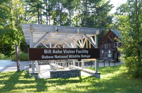
FORT DEVENS-SUDBURY TRAINING ANNEX
The 2,750-acre Fort Devens-Sudbury Training Annex Superfund site is a former U.S. Army military installation and was delisted in 2001. It covers about 4 square miles and includes parts of the towns of Maynard, Stow, Hudson and Sudbury, Massachusetts. Established in 1942, the installation served as an ammunition depot, ordnance test station, troop training and research area, and laboratory disposal area. The EPA identified contamination from use of pesticides and other chemicals on parts of the site. The EPA added the site to the National Priorities List (NPL) in 1990. The U.S. Army worked with the EPA to remove contaminated soil, cover an on-site landfill with a cap, remove underground storage tanks and monitor groundwater. In 2017, the Army started a preliminary assessment for per- and polyfluoroalkyl substances (PFAS). Based on the findings, the Army submitted a remedial investigation work plan for Areas of Contamination (AOC) A9 and P13 in fall 2023. AOC A7, a capped landfill, remains in long-term operation and maintenance, and continued land use controls limit future site use and restrict site access. Several entities own parts of the site. In 2000, the U.S. Army transferred 2,230 acres of the site to the U.S. Fish and Wildlife Service which established the Assabet River National Wildlife Refuge on the land. In 2005, the Service finished walking trails in the refuge. In 2008, it finished restoring Russell Bridge. In 2010, a visitor center and other park amenities opened at the refuge. The U.S. Fish and Wildlife Service used green building techniques for the visitor center, which includes a geothermal heating system and solar panels. The refuge provides recreation opportunities, including hiking, canoeing, guided tours of the military bunkers on-site, hunting and fishing. The U.S. Fish and Wildlife Service’s plans for the refuge include educational demonstration areas, restoration of on-site bunkers, an urban education area and a rail-to-trail project for the abandoned railroad on the south side of the refuge. The refuge receives about 75,000 visitors annually. In 2002, the U.S. Army transferred 4 acres to the U.S. Air Force. It uses the area for a radar and weather station. In 2003, the U.S. Army transferred about 72 acres of the site to the Federal Emergency Management Agency. It uses the land for its operations and training missions. It has cleared 6 acres for use as a temporary antenna field.
Last updated September 2024
As of December 2025, EPA did not have economic data related to on-site businesses, or economic data were not applicable due to site use. For additional information click here.
For more information:
GE - HOUSATONIC RIVER
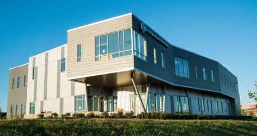
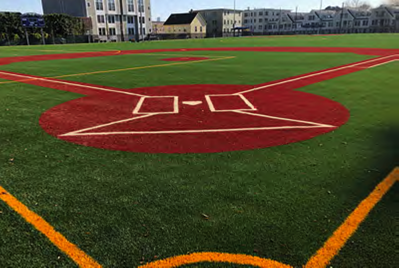
The GE-Pittsfield/Housatonic River site includes a 254-acre former manufacturing facility, filled river oxbows, neighboring commercial properties, the Allendale School, Silver Lake, the Housatonic River, floodplains and other areas. The site contains contamination released from the General Electric Company (GE) facility in Pittsfield, Massachusetts. A revised cleanup decision in the form of a Revised Corrective Action Permit for portions of the Housatonic River was issued in December 2020. A Consent Decree entered in federal court in 2000 outlined the cleanup of all other areas of the site. All 20 cleanup actions outside the river, all within the city of Pittsfield, are now complete. Cleanup of 2 miles of the Housatonic River is also already complete. As part of ongoing cleanup activities, the community prioritized the reuse of the former GE facility, located in the heart of downtown Pittsfield. Funded by a Superfund Redevelopment pilot grant from EPA, the Pittsfield Economic Development Authority (PEDA) developed a reuse plan. The plan outlined opportunities for sports fields and an office park. In 2004, GE built a 3-acre recreational facility on-site for the community. The facility includes a baseball diamond, soccer field, jogging track, equipment storage, fencing and lighting. Between 2005 and 2012, PEDA received ownership of 50 acres at the site for the development of the William Stanley Business Park. The facility provides commercial and industrial space for area businesses. The park’s first tenant, a financial services company, built a 170,000-square-foot building that opened in 2012. Western Massachusetts Electric Company installed an 8-acre solar power facility in 2010, using 2 acres of the site and 6 acres of an adjacent property, which generates 1.8 megawatts of electricity. In 2012 and 2013, a 26-acre lake and associated banks and floodplain were remediated. The bank/floodplain remediation included construction of a walking path, benches and the extensive planting of native trees and shrubs. In 2014, PEDA received a $9 million state grant to design and build the Berkshire Innovation Center (BIC). The BIC facility opened for business in February 2020. The facility supports shared research, early-stage production and commercialization, and workforce training for life science companies and related businesses. In 2022, the BIC received an additional $1 million from the American Rescue Plan Act for establishing a manufacturing academy to spur economic growth and jobs. A tech firm with city and state funding headquartered at the BIC is developing a solar masonry unit capable of generating energy from reflected light on the sides of buildings. The firm plans to have its production facility based at the BIC. Two large employers continue to operate on the GE-owned part of the 254-acre facility. Continued uses on the non-GE owned part of the site (excluding the Rest of River) include an elementary school, about 86 residential properties, about 35 commercial properties and a city park.
Last updated September 2024
As of December 2025, EPA had data on 41 on-site businesses. These businesses employed 2,468 people and generated an estimated $821,966,915 in annual sales revenue. For additional information click here.
For more information:
GROVELAND WELLS
The 850-acre Groveland Wells Superfund site is located off of Washington Street in Groveland, Essex County, Massachusetts. The former Valley Manufacturing Products Company made metal screws and plastic parts on-site until 2001, when the company ceased operations. The site's Responsible Party (PRP) released cutting oils and chlorinated hazardous solvents (TCE) at the site. Additional TCE product leaked from underground storage tanks and disposal systems at the facility. These releases contaminated the town of Groveland’s public water supply. The EPA added the site to the National Priorities List (NPL) in 1982. In late 1987 and early 1988, the RPs installed and used soil vapor extraction (SVE) to remove contaminants from site soils. The RPs also put in a small groundwater treatment system in 1988. However, these systems were ineffective. The EPA then designed and installed a large groundwater treatment system in 2000. In 2006, the EPA removed abandoned underground storage tanks, and a former disposal system and contaminated soils from the site. In addition, from 2009 to 2011, the EPA designed, installed and operated an electrical resistive heating treatment system to replace the SVE system. All of these treatment activities were effective. They concluded in 2014 and MassDEP continues to conduct long term groundwater sampling. The EPA’s Superfund Redevelopment Program and Region 1 did an assessment in 2010 to evaluate opportunities for using Superfund sites in Massachusetts for solar energy. In 2012, a 3.6-megawatt solar array was installed on another part of the site. It provides power for more than 500 homes. The site remains in continued residential, recreational, commercial, municipal and industrial use. Mill Pond and parts of Johnson Creek are also on-site. MassDEP properly decommissioned the site’s large groundwater treatment facility. The Roman Catholic Archdiocese of Boston owns the property and plans to use the decommissioned treatment facility building. The EPA transferred ownership of the empty, clean building to the Archdiocese in 2022. The EPA and MassDEP continue to monitor conditions, conducting groundwater monitoring and conducting Five Year Reviews every five years to make sure the remedies continue to remain protective of human health and the environment.
Last updated September 2024
As of December 2025, EPA did not have economic data related to on-site businesses, or economic data were not applicable due to site use. For additional information click here.
For more information:
HANSCOM FIELD/HANSCOM AIR FORCE BASE
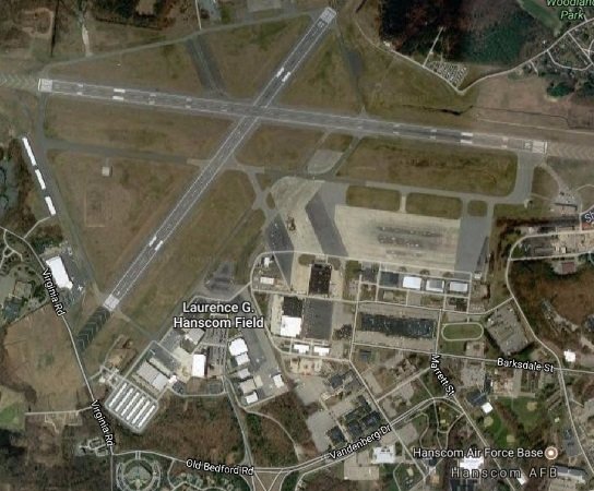
The 1,120-acre Hanscom Field/Hanscom Air Force Base Superfund site is located in an industrial area in eastern Massachusetts. It is in the towns of Bedford, Concord, Lexington and Lincoln. In 1942, the commonwealth of Massachusetts leased the Bedford airport to the War Department for use by the Army Air Forces. In February 1943, the airport was renamed Laurence G. Hanscom Field. Military flight operations at the site ended in 1973. In August 1974, the U.S. Air Force terminated its lease of the airfield portion of Hanscom Field, which reverted to state control, but retained the right to use the field. Military use of the site resulted in contamination of groundwater and subsurface soil with chlorinated solvents, jet fuel and other petroleum compounds. Investigations identified 22 possible sources, including former fire training, disposal, underground storage tank and other spill areas. Under state oversight before the site’s National Priorities List (NPL) listing in 1994, the Air Force completed interim remedial actions, including excavation of contaminated soil and underground storage tanks, and installation of a groundwater extraction and treatment system. The Air Force's cleanup plans, which are overseen by EPA, are documented in four Records of Decision issued between 2000 and 2007. Cleanup includes continued operation of the groundwater treatment system, land use controls, and monitoring of groundwater and surface water. Some site investigations, including for per- and polyfluoroalkyl substances (PFAS), are ongoing. Today, the Massachusetts Port Authority operates L.G. Hanscom Field as a civilian airport. Hanscom AFB, an active U.S. Air Force installation, operates nearby.
Last updated September 2024
As of December 2025, EPA did not have economic data related to on-site businesses, or economic data were not applicable due to site use. For additional information click here.
For more information:
HATHEWAY & PATTERSON
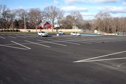
The 38-acre Hatheway & Patterson Superfund site is in Mansfield and Foxborough, Massachusetts. Approximately 36 acres of the site are located in the town of Mansfield and the remaining 1.77 acres are located in the town of Foxborough. The site is bisected by the Rumford River, which runs north to south, and by a railroad right-of-way, which runs east to west. The Hatheway and Patterson Company operated a wood-preserving facility on-site from 1953 to 1993. Releases of chemicals used during these operations resulted in soil and groundwater contamination. It also resulted in contamination of sediment and surface water in the Rumford River’s fisheries and surrounding wetlands. The EPA added the site to the National Priorities List (NPL) in 2002. Cleanup included removing contaminated soil, capping a 2-acre area, implementing institutional controls, and long-term monitoring of groundwater, surface water, fish tissue and sediment. The EPA completed the cleanup in 2011. Institutional controls in the form of Notice of Activity and Uses Limitations (NAULs) were recorded with the Registry of Deeds to prevent uncontrolled access to the remaining contamination. In 2018, the EPA deleted the site from the NPL because the EPA determined that the response actions for the site were complete and that all cleanup goals had been achieved. Today, a 119-space commuter parking lot is located on part of the site. It serves the nearby Mansfield commuter rail station. The town of Mansfield also uses part of the site for emergency vehicle storage and uses the remaining building for office space. The Mansfield portion of the site along County Street is not currently in use.
Last updated September 2024
As of December 2025, EPA did not have economic data related to on-site businesses, or economic data were not applicable due to site use. For additional information click here.
For more information:
HAVERHILL MUNICIPAL LANDFILL
The 71-acre Haverhill Municipal Landfill Superfund site is next to the Merrimack River in Haverhill, Massachusetts. Old Groveland Road runs along the southern border of the site. The landfill opened in the 1940s as an industrial landfill, began accepting municipal waste in the 1960s and continued to do so until its closure in 1981. From 1978 to 1996, sludge from the Haverhill wastewater treatment plant and byproducts from the paper manufacturing process at the Haverhill Paperboard Company were also disposed of at the landfill. The EPA added the site to the National Priorities List (NPL) in 1986. The site is also on the state’s 21E site list due to the potential for environmental impacts resulting from the burial of industrial and hazardous waste and is being closed (capped) under the MassDEP Solid Waste program, with the EPA's oversight. In 1996, the landfill was covered with a temporary soil cover. To address concerns about potential buried hazardous materials or “hot spots” at the landfill and subsurface investigations took place in December 2002. By May 2005, about 1,917 55 gallon drums of waste and 545 yards of contaminated soil were removed and taken off site for proper off-site disposal. In 2012, the southern part of the landfill was graded and capped. In 2021, Kearsarge Energy LP completed the renewable energy project on 12 acres of the southern part of the landfill under the Massachusetts SMART Program. The project combines photovoltaic energy production plus battery storage to feed 4.65 million kilowatt-hours into the utility grid annually. In partnership with Haverhill city government, energy savings, lease revenue and tax income are estimated at $3.9 million over 20 years. Planning for capping the site’s northern mound is underway. Long-term cleanup and environmental monitoring are ongoing under MassDEPs’ cleanup program.
Last updated September 2024
As of December 2025, EPA did not have economic data related to on-site businesses, or economic data were not applicable due to site use. For additional information click here.
For more information:
HOCOMONCO POND
The 23-acre Hocomonco Pond Superfund site is in Westborough, Massachusetts. Wood-treating operations occurred on-site from 1928 to 1946 and consisted of saturating wood products with creosote to preserve them. The wastes from this process went into a 1.7-acre unlined former lagoon and two other areas on-site. In 1976, the town of Westborough put in a storm drain. It crossed part of the former lagoon that contained creosote wastes, causing them to be discharged directly into Hocomonco Pond. Fish kills in 1979 and 1982 led to investigations that found the a source of the creosote contamination to enter the Pond. The EPA added the site to the National Priorities List (NPL) in 1983. Cleanup included source removal and control, landfill construction, capping of the former lagoon, relocation of the storm drain, and sediment removal and placement in the on-site landfill. Dense Non-aqueous Phase Liquids (DNAPL) in the deep bedrock below the groundwater table is manually removed and taken off-site for disposal every three months. Groundwater, sediment monitoring, DNAPL recovery, operation and maintenance activities and Five Year Reviews continue. The Pond is adjacent to the Site. The Town of Westborough owns the property and is considering possible re-uses of the site.
Last updated September 2024
As of December 2025, EPA did not have economic data related to on-site businesses, or economic data were not applicable due to site use. For additional information click here.
For more information:
INDUSTRI-PLEX

The Industri-Plex Superfund site in Woburn, Massachusetts, is located 12 miles outside of Boston. From 1853 to 1969, several manufacturers produced chemicals, insecticides, munitions and glue products at the site. Large waste piles, heavy metals and hazardous chemicals collected on-site. This waste resulted in groundwater, surface water, soil and sediment contamination. In 1983, the EPA added the site to the Superfund program’s National Priorities List (NPL). Cleanup included placement of protective covers over parts of the site, gas collection and thermal treatment, contaminated groundwater treatment in the Halls Brook Holding Area Pond, dredging and off-site disposal of contaminated sediments, construction of wetlands and a fish ladder, and institutional controls. The covers were compatible with productive reuse of the areas. The EPA has entered into five Prospective Purchaser Agreements (PPAs) at the site. A PPA encourages the reuse of Superfund site properties by addressing purchaser and lessee liability concerns. During and after initial cleanup activities, several public- and private-sector improvements took place. They included a new interstate highway exchange, public roads, a 200,000-square-foot shopping center, an office park and a hotel complex. Restored wetlands and grass-covered hills provide scenic open space at the site. The site’s successful redevelopment was recognized by the prestigious Phoenix Award in 2000. In 2001, the 34-acre, $10 million James Anderson Regional Transportation Center opened at the site. The center relieves congestion on highways leading into Boston and eases commutes for many area residents. In 2008 and 2009, additional redevelopment included a restaurant, a pet supply store and a furniture store. EPA, the state and the local government worked with the developer to record property use restrictions, prepare work plans, remove a building and support the property’s transformation. Construction of the final cleanup phase began in 2015 and was completed in 2017. Mitigation projects along the Aberjona River include constructed wetlands, floodplain enhancements and the Aberjona Nature Trail, as well as a fish ladder at the Center Falls Dam in nearby Winchester. The EPA continues to support the safe redevelopment of properties at the site, and prepared a 2018 Explanation of Significant Differences that enabled two mixed-use and residential projects to move forward. Construction of the first project, a 200-unit apartment community at 200 Presidential Way parcel, began in 2018 and finished in 2019. Construction of the second project, a 289-unit multi-family housing and over 9,000 square feet of commercial space development, began in 2019 and finished in 2022. In addition, the EPA took the 200 Presidential Way parcel off the NPL in 2020. In 2021, two solar rooftop projects were completed. They generate 1.7 and 0.8 megawatts of energy, respectively. In 2022, New Boston Street Rail Road Bridge construction began. It is scheduled for completion in 2025. The EPA provides oversight to ensure the remedy remains protective. In 2023, construction of a 4-megawatt Solar Electric Generating Facility finished. Other reuse projects on the horizon include a mixed-use area and a proposed life science laboratory and office complex.
Last updated September 2024
As of December 2025, EPA had data on 39 on-site businesses. These businesses employed 996 people and generated an estimated $237,280,512 in annual sales revenue. For additional information click here.
For more information:
INTERVALE STREET
The Intervale site is located in Quincy, Massachusetts. A metals recycling business operated on site. Sampling in 2012 detected polychlorinated biphenyls, lead, arsenic and chromium in site soils. The EPA removed about 4,400 tons of contaminated soil in 2014 and 2015. The city of Quincy will offer the site property for sale after completion of the EPA’s cleanup activities.
Last updated September 2024
As of December 2025, EPA did not have economic data related to on-site businesses, or economic data were not applicable due to site use. For additional information click here.
For more information:
IRON HORSE PARK
The Iron Horse Park Superfund site is a 553-acre industrial complex in Billerica, Massachusetts. Industrial activities, which began in 1913, included manufacturing, rail yard maintenance, waste storage and landfilling. These operations resulted in soil, groundwater and surface water contamination. The EPA added the site to the National Priorities List (NPL) in 1984. Remedy construction finished in 2022. It included removing contaminated soil, backfilling areas with clean soil, capping contaminated soil areas, and closing and capping landfills. These activities supported the continued operation of industrial businesses on-site, including lumber, manufacturing and rail yard maintenance facilities. Cleanup activities also restored natural marshes and created new wetland habitats. In 2012, site stakeholders began a project to place solar panels on the Shaffer Landfill, a former waste disposal area. After coordinating with the EPA and the state, the town of Billerica signed a payment in lieu of taxes (PILOT) agreement in August 2013. The agreement guarantees project revenue over 25 years. With the agreement in place, construction of the 25-acre solar array began in early 2014. Urban Green Technologies (UGT), the solar developer, placed 20,000 solar panels over the capped landfill. The EPA worked with UGT to address the challenge of installing solar panels on the sloped landfill while ensuring its cap remained intact. In August 2014, EPA, Massachusetts Department of Environmental Protection, UGT and the town of Billerica held a ceremony marking the project’s completion. The 6-megawatt facility allows the town to reduce its dependence on fossil fuels and benefit from significant long-term energy cost savings. Since then, a 4-megawatt solar array was constructed elsewhere on the site, followed by a 6-megawatt array in 2017. The solar facilities allow the town of Billerica to benefit from significant long-term energy cost savings.
Last updated September 2024
As of December 2025, EPA had data on 11 on-site businesses. These businesses employed 400 people and generated an estimated $208,204,404 in annual sales revenue. For additional information click here.
For more information:
- Reuse and the Benefit to Community: Iron Horse Park Superfund Site (PDF)
- Site Redevelopment Profile: Iron Horse Park Superfund Site (PDF)
- EPA Issues First "Re-use" Awards for New England Superfund Sites
- Superfund Site Profile Page
KING PHILIP MILLS
The King Philip Mills site is located in Fall River, Massachusetts. A cotton mill was built on site between 1871 and 1892. The EPA identified drums, containers and cylinders at the site. In November 2014, the EPA completed a time-critical removal action to remove contaminated drums and containers as well as asbestos-containing material. The EPA completed a second time-critical removal action in March 2017 to remove polychlorinated biphenyl oils from contaminated materials. In June 2017, a developer bought the site property at auction. The developer plans to create about 90 upscale residential units and open space with public access along Cook Pond.
Last updated September 2024
As of December 2025, EPA did not have economic data related to on-site businesses, or economic data were not applicable due to site use. For additional information click here.
For more information:
LAWRENCE METALS (FORMER)
The Former Lawrence Metals site is located in Chelsea, Massachusetts. From the late nineteenth century until 1974, when a fire destroyed the building, owner operators used the site property for textile production, barrel cleaning and painting. From 1979 to 1986, operators used the property for warehouse space. In 1986, the Lawrence Metals Forming Company began operating on site. Its operations resulted in the contamination of soil and site materials. In 1999, the city of Chelsea acquired the site property under an Urban Renewal Plan. The city demolished the site building in 2000. EPA, the city and state agencies coordinated cleanup, including the excavation of contaminated soil. The project was particularly challenging because of its proximity to a school and a city swimming pool. An upscale, extended-stay hotel is now located on site.
Last updated September 2024
As of December 2025, EPA had data on one on-site business. This business employed 25 people and generated an estimated $910,000 in annual sales revenue. For additional information click here.
For more information:
LEWIS CHEMICAL CORP
The Lewis Chemical site covers 0.9 acres and consists of three properties in Suffolk County, Massachusetts. The city of Boston owns two of the properties. The commonwealth of Massachusetts owns the third. The site abuts the Neponset River to the south and the Fairmount Massachusetts Bay Transportation Authority (MBTA) Train Station to the north. Several businesses occupied the city-owned properties in the late 1800s and early 1900s. From 1940 until the early 1960s, Leather Manufacturing Co., Inc operated on-site. Lewis Chemical Corp. operated on-site from 1963 to 1983, collecting, transporting, storing and processing hazardous wastes. The city demolished the Lewis Chemical industrial facility in 2013. In 2022, the city requested the EPA’s assistance to address the inorganic and organic contaminants found on site. The EPA assessed the site and found that there was potential for further release of contaminants. The EPA began a removal action in 2023 with the goal to eliminate the direct contact threat and remove the source contamination by removing and disposing of contaminated soil. Polychlorinated biphenyls (PCBs) were the primary contaminant of concern (COC). Cleanup included excavation and off-site disposal of over 5,700 tons of contaminated soil and site restoration. On October 4, 2024, EPA Region 1 staff, U.S. Senator Edward J. Markey, Boston Mayor Michelle Wu, Massachusetts Department of Environmental Protection Commissioner Bonnie Heiple and members of community organizations gathered at Hyde Park along the Neponset River to celebrate the completion of the cleanup at the Lewis Chemical site.
Last updated September 2024
As of December 2025, EPA did not have economic data related to on-site businesses, or economic data were not applicable due to site use. For additional information click here.
For more information:
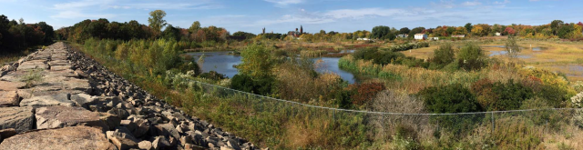
LOWER NEPONSET RIVER

The Lower Neponset River Superfund site is a 3.7-mile section of the Neponset River between Hyde Park and Dorchester/Milton, Massachusetts. The site boundary begins at the confluence of the Neponset River and Mother Brook and extends to the Baker Dam. Based on preliminary studies, this portion of the river contains sediment contaminated with polychlorinated biphenyls (PCBs). In 2006 and 2007 the Massachusetts Department of Environmental Protection oversaw a large removal of contaminated sediments in Mother Brook, which feeds into the Neponset River. Further sampling found PCB contamination in the Neponset River. The EPA added the site to the National Priorities List in 2022. The EPA finished phase I remedial investigations in 2023. Phase II investigations, an engineering evaluation and a cost analysis are planned for 2024. The site’s 2023 Reuse Assessment Report identified reasonably anticipated future land uses to guide the EPA's cleanup decision-making process and inform land use planning activities. The reuse assessment process included interviews and other information sharing opportunities for community members and stakeholders to share their perspectives and visions for the future of the site. The process identified strong community interest in the future use of the site as a recreational space. Currently, many public recreational land uses, including trails, parks, playgrounds and community gardens, are near the site. However, some neighborhoods with environmental justice concerns are more isolated from the river and lack access to it and nearby parks. Several local efforts are improving access in these areas.
Last updated September 2024
As of December 2025, EPA did not have economic data related to on-site businesses, or economic data were not applicable due to site use. For additional information click here.
For more information:
MANSELL FIELD
The 1.5-acre Mansell Field site is in Salem, Massachusetts. In 2018, the city of Salem found high levels of arsenic, lead and chromium in soil at the site. The contamination likely came from tannery operations. In 2019 and 2020, the EPA removed contaminated soil from three residential properties. In 2019, the city contacted the EPA to help with removing contaminated soil from Mansell Field, a public park that closed in 2018. The EPA and the city agreed to each lead part of the cleanup. Following the EPA’s cleanup, the city is now cleaning up remaining soil and restoring Mansell Field as a public park. Park restoration plans include a new basketball court and trees and a basin to manage stormwater.
Last updated September 2024
As of December 2025, EPA did not have economic data related to on-site businesses, or economic data were not applicable due to site use. For additional information click here.
For more information:
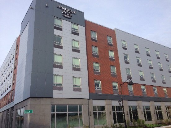
MATERIALS TECHNOLOGY LABORATORY (USARMY)
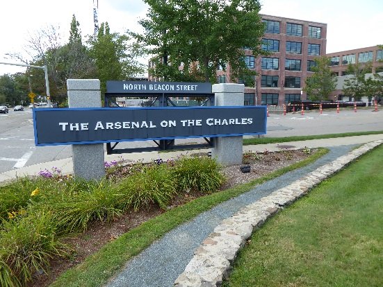
The 48-acre Materials Technology Laboratory (USARMY) Superfund site, better known as the Arsenal, is in Watertown, Massachusetts. In 1816, the U.S. Army began operations at the site; 10,000 people worked there by the end of World War II. The Army used the area for a variety of military- and war-related activities, including weapons and ammunition manufacturing and storage. In the 1960s, the U.S. Army used the site for nuclear reactor and molecular and atomic structure research activities. Waste generated by the facility contaminated soil and groundwater. The EPA added the site to the National Priorities List (NPL) in 1994. Cleanup removed contamination and demolished an on-site nuclear reactor. From 1996 to 2005, the Watertown Arsenal Development Corporation (WADC) helped redevelop 30 acres of the site. Harvard University bought the area and built a mixed-use complex called Arsenal on the Charles, which incorporates the style and architecture of the original brick buildings in the area. The complex includes stores, restaurants, a child-care facility, a fitness center, corporate offices and other businesses. The Arsenal Center for the Arts, also in the complex, is an important cultural asset in the community; it has a theater, gallery space, artists’ studios, and other resources and services. The current owner, Alexandria Real Estate Equities, has transitioned many of the former Arsenal site’s buildings from traditional office space to life-science based laboratories in the last few years. Many existing buildings have undergone renovations to allow for research and discovery, and to allow experts on every level to blend science and technology solutions to improve lives. Two new buildings with over 250,000 square feet combined are in the construction phase. The Commander’s Mansion, a historic landmark, occupies a 7.2-acre area of the site; it provides space for meetings and formal functions. The popular Squibnocket Park is located on an 11-acre parcel along the Charles River; it provides biking and walking trails as well as access to the Watertown Yacht Club, a privately owned marina. The U.S. Army restored wetlands along the Charles River. The EPA deleted the site off the NPL in 2006; some cleanup activities are still ongoing at the Arsenal, as construction projects have found soils with chlorinated compounds.
Last updated September 2024
As of December 2025, EPA did not have economic data related to on-site businesses, or economic data were not applicable due to site use. For additional information click here.
For more information:
- Reuse and the Benefit to Community Materials Technology Laboratory Superfund Site (PDF)
- Superfund Site Profile Page
NATICK LABORATORY ARMY RESEARCH, DEVELOPMENT, AND ENGINEERING CENTER
The 78-acre site formerly known as the Natick Laboratory Army Research, Development, and Engineering Center now known as the U.S. Army Soldier Systems Center (SSC) is a Superfund site in Natick, Massachusetts. The site occupies a peninsula on the eastern shore of Lake Cochituate State Park and Recreation Area. The U.S. Army built the Natick Laboratory in 1954 and conducts research and development activities on-site. These activities contaminated soil, groundwater and surface water with hazardous chemicals. In 1989, personnel at the facility noticed a sheen on water running off the site during rainstorms. Construction workers also noticed a benzene-like odor in soil on-site. The U.S. Army conducted soil gas surveys and detected several volatile organic compounds. Soil, groundwater and surface waste sampling also showed contamination. The EPA added the site to the National Priorities List (NPL) in 1994. Ongoing cleanup activities include groundwater containment, treatment and monitoring. Former cleanup activities also included soil excavation and removal, and sediment removal. Treated groundwater is reused as non-drinkable water for irrigation and toilets. The SSC still operates a U.S. Army research and testing facility on-site. It includes buildings and open, uncovered areas including a softball field. The facility supports the research, development and management of food, clothing, shelters, airdrop systems and soldier support items. The facility currently employs about 1,000 people.
Last updated September 2024
As of December 2025, EPA did not have economic data related to on-site businesses, or economic data were not applicable due to site use. For additional information click here.
For more information:
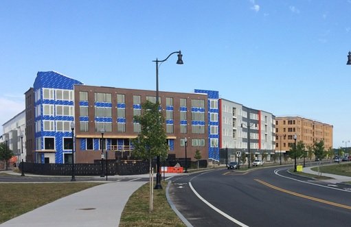
NEW BEDFORD
The 18,000-acre New Bedford Harbor Superfund site is in New Bedford, Fairhaven, Acushnet and Dartmouth, Massachusetts. At least two companies produced capacitors containing polychlorinated biphenyls (PCBs) on-site from 1940 to the late 1970s. Operations discharged industrial waste into the harbor, which contaminated the estuary from the upper Acushnet River into Buzzards Bay. In 1983, the EPA added the site to the National Priorities List (NPL). Ongoing cleanup activities include the removal and disposal of contaminated shoreline soils, salt marshes and mudflats at approved off-site facilities, and replanting impacted salt-marsh areas with thousands of native grasses, shrubs and trees. Subtidal dredging (below the low tide line) finished in 2020. Cleanup is ongoing and is expected to be completed by December 2025. In December 2020, after extensive decontamination, the EPA transferred its former 5-acre sediment dewatering facility to the city of New Bedford. To provide COVID-19 vaccinations for seafood industry workers and community members during the COVID-19 public health emergency, the city partnered with the Greater New Bedford Community Health Center in April 2021 to temporarily transform the facility into a COVID-19 vaccination site, capable of vaccinating up to 800 to 1,000 people daily. In 2022, the city used the facility to temporarily protect various Buttonwood Park Zoo waterfowl and endangered species from Highly Pathogenic Avian Influenza H5N1. The facility is now being used as a staging area for construction of the North Terminal. The city ultimately plans to use the former dewatering facility as a heavy-duty, multi-purpose port facility, potentially supporting offshore wind energy projects. The facility, located on the city’s working waterfront, includes berthing space for freighters and commercial fishing vessels, a 55,000-square-foot warehouse, and a rail spur that connects to the city’s rail yard. As part of a separate Superfund removal action next to the harbor in 2011, the EPA completed demolition of the 11-acre Aerovox mill, located along the Acushnet River. The cleanup plan also allows for navigational dredging efforts by local and state stakeholders. Dredging of harbor channels, which enhances the remedy by removing sediment not addressed by the Superfund cleanup, has resulted in private investment in the commercial port. It paved the way for the recent construction of the New Bedford Marine Commerce Terminal (aka the South Terminal), a 28-acre marine terminal supporting the construction of offshore wind energy. In December 2021, the site was among those selected by the EPA to receive cleanup funding under the Infrastructure Investment and Jobs Act. With this funding, the EPA is already initiating work on backlogged remedial construction projects and accelerating cleanups at National Priorities List (NPL) sites. IIJA funds will enable the completion of all remaining remediation by December 2025. These activities will include the cleanup of four shoreline intertidal zones, off-site disposal of dredged material stored at the EPA’s Sawyer Street facility, capping of the confined disposal facility at Sawyer Street, and full demobilization and return of the shoreline Sawyer Street facility to the city of New Bedford for redevelopment, including its planned upper harbor river walk. Redevelopment along the river is ongoing. Projects include the repurposing of many former mills for apartments and commercial space. Finally, plans include a river walk along the Upper Harbor and habitat restoration, which will draw residents back to the waterfront for recreation activities. The EPA’s cleanup will address contamination along the shoreline. Once the ongoing state-led cleanup of the upland portion of the former Aerovox mill finishes, the property will provide the city with space for potential future shoreline redevelopment. Residents use the harbor for recreational activities such as rowing and boating.
Last updated September 2024
As of December 2025, EPA did not have economic data related to on-site businesses, or economic data were not applicable due to site use. For additional information click here.
For more information:
- New Bedford SuperJTI 2024 Fact Sheet (PDF)
- Site Redevelopment Profile: New Bedford (PDF)
- Reuse Fact Sheet: New Bedford Superfund Site (PDF)
- Superfund Site Profile Page
NORWOOD PCBS
The 26-acre Norwood PCBs Superfund site is in Norwood, Massachusetts. From 1942 through the mid-1980s, several businesses made and maintained electrical components on-site. During investigations, the EPA found polychlorinated biphenyls (PCBs) in soil and groundwater on-site and in the sediment of a nearby brook. In 1986, the EPA added the site to the National Priorities List (NPL). Cleanup included removing contaminated soil and sediment and consolidating it beneath an asphalt cap. It also included demolition of site structures and long-term monitoring. A groundwater treatment facility operated on-site until 2001. In 2008, the site owner and developers completed a 56,000-square-foot commercial facility on-site. Developers also put new buildings next to the capped area. They increased the thickness of the asphalt cap remedy to allow for its use as a parking lot. An athletic goods retailer remains in the facility. The EPA took the site off the NPL in 2011. Various enterprises have operated in the commercial buildings on the property in accordance with institutional controls on the parcels that ensure the protectiveness of the remedy.
Last updated September 2024
As of December 2025, EPA had data on 2 on-site businesses. These businesses employed 2 people and generated an estimated $674,000 in annual sales revenue. For additional information click here.
For more information:
NUCLEAR METALS, INC.
The Nuclear Metals, Inc. Superfund site includes a 46-acre property in the western part of the town of Concord, Massachusetts. It also includes a contaminated groundwater plume that extends under nearby areas. Facility operations at the site took place from 1958 to 2011. Nuclear Metals, Inc. was originally a specialty metal research and development facility licensed to possess low-level radioactive substances. It later developed into a large-scale industrial facility that made depleted uranium products. From 1958 to 1985, the facility sent waste into an unlined holding basin. Historical activities at the site resulted in soil, sediment, and groundwater contamination. The EPA added the site to the National Priorities List (NPL) in 2001. Interim cleanup under the removal program included the removal of 8,000 cubic yards of soil from the holding basin, lining of the holding basin, and fencing and capping of the on-site landfill. It also included a time-critical action to remove hazardous and flammable material, demolition of on-site buildings, temporary capping of the former building area, and off-property groundwater extraction and treatment. Long-term cleanup is underway to provide permanent solutions for on-property groundwater, sitewide soils and sediment, and the Holding Basin area. The EPA’s Superfund Redevelopment Program (SRP) supported a reuse assessment at the site from 2018 through 2020 to assist local stakeholders in planning for future land use, redevelopment, property ownership and long-term stewardship at the site. In 2023, SRP initiated phase two of reuse support to assist the town with understanding their property acquisition and liability protection options and a strategy for acquisition and potential disposition. In addition, the EPA will be working with local stakeholders to refine the remedial design and doing site reuse planning analyses to assist with remedial design and reuse planning integration. The site is vacant. Continued ecological uses on-site include wetlands and a pond.
Last updated September 2024
As of December 2025, EPA did not have economic data related to on-site businesses, or economic data were not applicable due to site use. For additional information click here.
For more information:
NYANZA CHEMICAL WASTE DUMP
The 35-acre Nyanza Chemical Waste Dump Superfund Site (the “Site”) is in Ashland, Massachusetts, 25 miles west-southwest of Boston, Massachusetts. The Site consists of the former Nyanza, Inc. property and surrounding areas impacted by the contamination. A plume of groundwater contamination flows from the former Nyanza, Inc. property northeast below downtown Ashland, a densely populated area of mixed residential and commercial use, toward the Sudbury River. From 1917 to 1978, companies made textile dyes, dye intermediates and other products at the Site. Operators buried solid waste on Megunko Hill, and released manufacturing wastewater into a system of on-site lagoons and an underground concrete vault that were periodically discharged to a series of drainage ways and wetlands hydraulically connected to the Sudbury River. These improper waste-handling practices resulted in groundwater contamination and soil and sediment contamination, particularly mercury and volatile organic compounds (VOCs) such as trichloroethylene (TCE). The EPA added the Site to the National Priorities List (NPL) in 1982. In the mid-1990s, data from indoor air samples collected in buildings above a contaminated groundwater plume emanating from the Site indicated the potential for vapor intrusion of VOCs from soil below building foundations into indoor air. Cleanup activities between 1989 to 2001 have included excavating sludge and contaminated soils and sediments from the former Nyanza, Inc. manufacturing property and surrounding wetland areas, and capping the Megunko landfill. In 2007, the EPA installed sub-slab depressurization systems in buildings within a designated vapor mitigation area to mitigate the vapor intrusion risk from VOCs in the Site groundwater plume. The EPA has initiated long-term groundwater monitoring events to further study the plume and expanded indoor air studies. In 2013, the EPA installed two extraction well systems in the source area to remove and recover dense non-aqueous phase liquid (DNAPL), which is contributing to ongoing groundwater contamination. The EPA has also conducted extensive mercury studies and sampling of sediment and fish tissue in the Sudbury River impacted by the Site discharges. Approximately 70 fish advisory signs have been posted at accessible locations along a 26-mile stretch of the Sudbury River in Ashland, Framingham, Sudbury, Wayland, Lincoln, and Concord to notify the public and discourage consumption of fish which may have elevated mercury levels. The EPA’s cleanup efforts have allowed for Site landowners to continue leasing land to several industrial and commercial businesses, including a chemical manufacturer. Several redevelopment projects next to the site have occurred in recent years, including a renovated MBTA commuter rail station and new parking lot, a large apartment complex with walkability to the MBTA station, the paved Trolley Brook recreation path, Mill Pond Park improvements including a new bridge and nature walkway over Mill Pond, which is part of the Sudbury River. Downtown Ashland has several new businesses, a Historical Society, an outdoor business and community gathering space, and recent improvements to sidewalks and crosswalks. A peaceful healing garden was also built near the Site to remember residents who were impacted by cancer. A new residential and commercial mixed-use development at a former mill property is also in the planning phase. Ecological uses on-Site include wetlands, Trolley Brook and the Sudbury River, which can be appreciated by the public from the new recreation path and nature walkway. In December 2019, a solar array was built and began operating on the Site's Megunko landfill cap. This array, together with a nearby off-site solar array, can generate up to 5.8 megawatts of electricity. In 2023, the Site was added to those selected by the EPA to receive cleanup funding under the Infrastructure Investment and Jobs Act. With this funding, the EPA is initiating work on backlogged remedial construction projects and accelerating cleanups at NPL sites. The EPA is implementing more groundwater cleanup measures at the Site with some of these resources.
Last updated September 2024
As of December 2025, EPA had data on 5 on-site businesses. These businesses employed 35 people and generated an estimated $9,350,140 in annual sales revenue. For additional information click here.
For more information:
OTIS AIR NATIONAL GUARD BASE/CAMP EDWARDS
The 22,000-acre Otis Air National Guard Base/Camp Edwards Superfund site is located on western Cape Cod in Barnstable County, Massachusetts. Also known as Joint Base Cape Cod (JBCC) (formerly known as Massachusetts Military Reservation until July 13, 2013), the site lies about 60 miles south of Boston and is immediately southeast of the Cape Cod Canal. Since its establishment in 1935, JBCC's primary mission has been to provide training and housing to U.S. Air Force and U.S. Army units. Past chemical and fuel spills, fire training activities, and sewage treatment plant, landfill and drainage structure operations contaminated soil and groundwater. Investigations in 1983 and 1984 found volatile organic compounds (VOCs) in on-site and nearby monitoring wells, as well as in several hundred private wells. Other site contaminants include heavy metals and PFAS (per- and polyfluoroalkyl substances). The EPA added the site to the National Priorities List (NPL) in 1989. The EPA documented site cleanup plans in over 15 Records of Decision. Cleanup activities include extension of water supply lines to affected homes, installation of municipal water supply well treatment systems, treatment of 100,000 tons of soil, and construction and operation of many on-site and off-site groundwater treatment plants. Groundwater treatment systems operate on eight groundwater plumes. The U.S. Air Force has completed cleanups at 25 source areas. Cleanup of four former plumes has been completed. The U.S. Air Force has taken actions to address immediate risks from PFAS in groundwater by providing bottled water, in-house drinking water treatment units, municipal water supply wellhead treatment and connection of homes to the public water supply. Investigations and feasibility studies of PFAS and former military munitions sites are ongoing, alongside long-term cleanup of contamination groundwater plumes and maintenance of land use controls. The Barnstable County Correctional Facility, a jail with capacity for about 580 inmates, opened on-site in 2004. The U.S. Air Force installed three 1.5-megawatt wind turbines – one in 2009 and two in 2011 – to offset electrical costs for groundwater cleanup systems at the site. It estimates that the wind energy saves about $1.5 million a year in electricity costs. The EPA’s plans enabled continued site operations during cleanup. Today, five organizations use the site: the Massachusetts Air National Guard (ANG) operates Camp Edwards, the ANG/Massachusetts ANG operates Otis ANG Base, the U.S. Air Force operates the Cape Cod Air Force Station, the U.S. Coast Guard operates Air Station Cape Cod and the U.S. Department of Veterans Affairs operates the Massachusetts National Cemetery. Ecological resources at the site include several ponds and wetland areas.
Last updated September 2024
As of December 2025, EPA did not have economic data related to on-site businesses, or economic data were not applicable due to site use. For additional information click here.
For more information:
PARSONS PAPER MILL
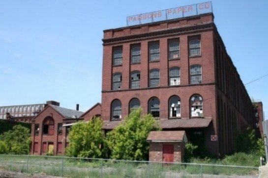
The 4.6-acre Parsons Paper site is located in Holyoke, Massachusetts. From 1896 to 2004, operators made writing and stationary paper as well as artist paper and archival paper for the art and framing industries on site. In 2008, a fire destroyed about 50% of the mill. The fire also damaged remaining parts of the interconnected building complex. In 2009, the EPA’s sampling identified asbestos in the burned areas. Sources of asbestos includes asphalt shingles, window glazing and caulking, tank and pipe insulation, transite siding, cements and mastics, and floor tiles. In 2009 and 2010, the EPA removed hazardous materials and asbestos that posed a threat to public health. In 2016, building demolition began for the expansion of Holyoke manufacturer Aegis Energy Services on site.
Last updated September 2024
As of December 2025, EPA had data on one on-site business. EPA did not have further economic details related to this business. For additional information click here.
For more information:
PEABODY STREET ASBESTOS

The Peabody Street Asbestos site is located in Salem, Massachusetts. The city of Salem identified asbestos during construction of a park in the downtown area. The EPA excavated contaminated soil because of the urban setting and because the city and state did not have funds for the excavation. The EPA recovered most expenses from the polluter. The city resumed construction of the park after the EPA completed the excavation. Completed in 2010, the Peabody Street Park/Harborwalk serves as a gateway to the city of Salem’s harbor. The park includes a playground, a canopy area, and seating for outdoor entertainment as well as game tables, benches and landscaping.
Last updated September 2024
As of December 2025, EPA did not have economic data related to on-site businesses, or economic data were not applicable due to site use. For additional information click here.
For more information:
PSC RESOURCES
The 4-acre PSC Resources Superfund site is in Palmer, Massachusetts. From 1898 to 1974, various oil companies owned the property. From 1974 to 1978, PSC Resources Inc. Operated a waste oil and solvent recovery and disposal facility on site. The owner abandoned the facility in 1978, leaving millions of gallons of waste behind in tanks and lagoons. Site operations also contaminated surrounding soil, sediment and groundwater with organic contaminants and metals. The EPA added the site to the National Priorities List (NPL) in 1983. The Performing Settling Defendants led the remedial design and remedial action, which occurred in two phases. The first phase entailed the decontamination, demolition and off-site disposal of structures. The second phase entailed all other remedial activities, which included ex-situ treatment and stabilization of sediment and soil that was then placed under a low-permeability cap. The capped area is fenced to prevent access by the public. The restoration of wetlands, implementation of institutional controls on groundwater use and land development, and long-term monitoring of groundwater has occurred since completion of the remedy. Environmental monitoring in sediment and surface water were suspended after performance standards were achieved in the lagoon, wetland, and Quaboag River. The site includes forest and wetland areas that are used by local residents for recreation activities. A Mobil Oil Company pipeline right-of-way extends along the southwest boundary of the site.
Last updated September 2024
As of December 2025, EPA did not have economic data related to on-site businesses, or economic data were not applicable due to site use. For additional information click here.
For more information:
RE-SOLVE, INC.
The 6-acre Re-Solve, Inc. Superfund site is a former waste chemical reclamation facility in North Dartmouth, Massachusetts. Between 1956 and 1980, site operators disposed of residues from operations, liquid sludge waste, impure solvents, and burned tires in on-site unlined lagoons. Site operators also spread oil waste over the site to control dust. The EPA placed the site on the National Priorities List (NPL) in 1983. A groundwater pump-and-treat system was constructed at the site to contain and remove contaminants in overburden groundwater, which has operated continuously since 1998. As part of the cleanup, one acre of wetlands was remediated and restored. The potentially responsible parties (PRPs) also worked closely with the EPA and the U.S. Fish and Wildlife Service to convert 4 acres of the site into a native meadow for ecological reuse. The PRPs placed bird boxes, brush piles, and sand piles for turtles to enhance the meadow habitat. Fishing derbies have been held at Cornell Pond to engage the community in fish monitoring activities. The EPA and the PRPs have also collaboratively evaluated sustainable treatment enhancements for the groundwater treatment system since 2004. In 2015, two anaerobic bio-reactor systems were constructed at the site. The systems are below-ground sand/peat beds in which naturally occurring microorganisms break down the contamination. This process significantly reduces the use of chemicals and the need for waste disposal. The groundwater treatment system is powered entirely by solar panels.
Last updated September 2024
As of December 2025, EPA had data on one on-site business. EPA did not have further economic details related to this business. For additional information click here.
For more information:
ROSE DISPOSAL PIT
The Rose Disposal Pit Superfund site is a 12.5-acre former waste disposal area in Lanesborough, Massachusetts. From 1951 to 1959, operators put waste oils and solvents from the nearby General Electric plant in an open trench at the site. In 1980, a state inspection found soil and groundwater contamination. Immediate actions protected human health and the environment. They included providing alternate water supplies to affected homes, removing and treating contaminated soil, covering the disposal area, and extracting and treating contaminated groundwater. The actions also treated sediments and surface water from a pond near the disposal area. The EPA added the site to the National Priorities List (NPL) in 1984. Long-term cleanup included excavation and incineration of contaminated soil and sediment, placement of a clean soil cover, groundwater treatment, ecological restoration, and land and groundwater use controls. Construction of the groundwater extraction and treatment systems finished in 1993. Soil cleanup finished in 1994. GE demolished the Rose residence on-site in 2009. General Electric owns the site, which is vacant. The groundwater treatment facility continues to operate. A collection trench and several monitoring wells are on an adjacent Balance Rock State Park property. Ecological uses on-site include a pond.
Last updated September 2024
As of December 2025, EPA did not have economic data related to on-site businesses, or economic data were not applicable due to site use. For additional information click here.
For more information:
SALEM ACRES
The 235-acre Salem Acres Superfund site is in Salem, Massachusetts. From 1946 to 1969, part of the site received waste from the South Essex Sewerage District. The waste was placed in unlined pits. Other areas of the site were used for fly ash disposal and a landfill. The unlined pits, the fly ash pile and the landfill contained hazardous substances. The EPA added the site to the National Priorities List (NPL) in 1986. From 1995 to 1999, responsible parties removed and disposed of site contamination, with the EPA's oversight. The cleanup restored the area for unrestricted land use. The EPA took the site off the NPL in 2001. In 2019, a developer expanded a neighborhood of single-family homes onto part of the site.
Last updated September 2024
As of December 2025, EPA did not have economic data related to on-site businesses, or economic data were not applicable due to site use. For additional information click here.
For more information:
SHPACK LANDFILL
The 9.4-acre Shpack Landfill Superfund site is in Attleboro and Norton, Massachusetts. The landfill operated from 1946 until the 1970s. It received domestic and industrial wastes, including inorganic and organic chemicals, as well as radioactive waste ashes associated with nuclear fuel operations. Facility operations contaminated soil, sediment and groundwater with hazardous chemicals. The EPA added the site to the National Priorities List (NPL) in 1986. Cleanup included excavation and off-site disposal of contaminated soil, installation of a water supply line, stormwater drainage improvements, wetland creation and restoration, and institutional controls. The EPA took the site off the NPL in 2017. An electrical utility easement with overhead distribution and transmission lines crosses the site. Routine maintenance and monitoring activities are ongoing to ensure wetland system health.
Last updated September 2024
As of December 2025, EPA did not have economic data related to on-site businesses, or economic data were not applicable due to site use. For additional information click here.
For more information:
SOUTH WEYMOUTH NAVAL AIR STATION
The South Weymouth Naval Air Station consists of 1,442 acres in the towns of Weymouth, Abington and Rockland, Massachusetts. Military operations at the site included aviation training, aircraft maintenance and refueling, personnel training, housing, and administrative support services. Waste disposal activities also took place at the site. Sampling confirmed on-site contamination in 1991. The EPA added the site to the National Priorities List (NPL) in 1994. The base closed under the Base Realignment and Closure Act (BRAC) and cleanup began in 1997. Cleanup activities included soil covers and removals, groundwater treatment and land use restrictions. The Navy, with the EPA's oversight, continues ongoing cleanups and investigations, including for per- and polyfluoroalkyl substances (PFAS). The local reuse authority, the U.S. Coast Guard, the Federal Aviation Administration, and the Towns of Rockland and Weymouth have received over 1,393 acres of the site. Redevelopment efforts are ongoing, with over 1,274 residences and a 25-acre athletic complex currently on-site. Current mixed-use zoning allows for up to 2 million square feet of commercial space, nearly 6,000 additional residences, and approximately 900 acres of open space. The site also includes ecological features such as rivers, wetlands and ponds.
Last updated September 2024
As of December 2025, EPA did not have economic data related to on-site businesses, or economic data were not applicable due to site use. For additional information click here.
For more information:
SULLIVAN'S LEDGE
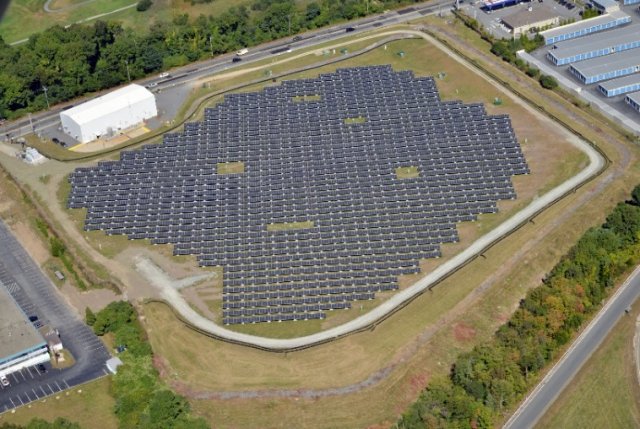
The 12-acre Sullivan’s Ledge Superfund site is in New Bedford, Massachusetts. A quarry operated on-site until about 1932. In 1935, the city of New Bedford took over the area and turned it into a dump for hazardous materials and other waste. Disposal activities took place on-site from the 1940s through the 1970s. The city then closed the dump and backfilled the disposal area following a fire in the 1970s. In 1982, during investigations associated with a proposed parking lot development, the Massachusetts Department of Public Works, now the Massachusetts Highway Department, found soil contamination at the site. The EPA led studies in the area and added the site to the National Priorities List (NPL) in 1984. Cleanup activities included treating groundwater and removing contaminated soil and sediment and capping the site. Institutional controls are recorded with the Registry of Deeds to prevent uncontrolled access to the remaining contamination. Groundwater treatment is ongoing. Cleanup also included removing contamination from a neighboring golf course. The EPA’s approach allowed for continued use of the golf course during cleanup. The EPA also restored 13 acres of affected wetlands. Restoration work finished in 2002. Today, the wetlands provide habitat for many wildlife species, including the great blue heron, great egret, red-tailed hawk and spotted turtle. The EPA’s Superfund Redevelopment Program and Region 1 did an assessment of the site in 2010 as part of an effort to evaluate opportunities for using Superfund sites in Massachusetts for solar energy. In 2013, the EPA approved the installation of a 1.75-megawatt solar project on the capped part of the site. Project partners SunEdison, Beaumont Solar, Pro-Tech Energy Solutions and BlueWave Capital completed construction in 2014. The 10-acre system includes more than 5,000 solar panels. A partnership between BlueWave Capital and the city of New Bedford supported further solar projects around New Bedford. The city of New Bedford buys energy generated from the solar arrays. This enables the city to increase its use of renewable energy sources and save 30% on municipal electricity bills. Over the course of 20 years, New Bedford will save about $2.7 million in energy costs through the purchase of solar net metering credits. In 2014, the EPA recognized the project team, including the city of New Bedford, BlueWave Capital and SunEdison, with the EPA Region 1’s first Excellence in Site Reuse award.
Last updated September 2024
As of December 2025, EPA had data on 2 on-site businesses. EPA did not have further economic details related to these businesses. For additional information click here.
For more information:
- Utility-Scale Solar Energy Development: The Sullivan's Ledge Superfund Site in New Bedford, Massachusetts (PDF)
- Region 1 Excellence in Site Reuse Award: Sullivan's Ledge Site
- Superfund Site Profile Page
SUTTON BROOK DISPOSAL AREA
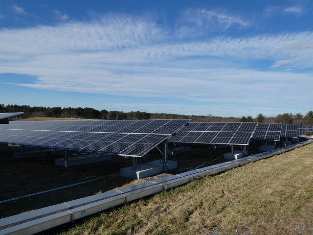
The 100-acre Sutton Brook Disposal Area Superfund site is in Tewksbury, Massachusetts. From 1957 until 1988, a landfill was active on-site. It accepted municipal, commercial, and industrial wastes. Waste disposal practices led to soil, sediment, surface water, and groundwater contamination at levels that pose unacceptable risks. The EPA added the site to the National Priorities List (NPL) in 2001, and led three short-term cleanups on and near the site - excavating and removing highly contaminated soils and drums. The long-term remedy included excavation of more soils and sediments, consolidation of this material in on-site landfills, landfill capping, and wetlands restoration. The remedy also included installation of an underground slurry wall to direct contaminated groundwater to an extraction well for removal and discharge to the local publicly owned treatment works (POTW), monitored natural attenuation for groundwater outside of the extraction system area, institutional controls, and long-term monitoring. Construction of the remedy was completed in July 2016 and monitoring of restored wetland areas is ongoing. In June 2020, MassDEP approved the own of Tewksbury’s request to install ballast-mounted solar arrays at the site. In 2022, National Grid energized the 3.6-megawatt solar array project.
Last updated September 2024
As of December 2025, EPA did not have economic data related to on-site businesses, or economic data were not applicable due to site use. For additional information click here.
For more information:
UNIVERSAL STEEL & TRADING CORPORATION
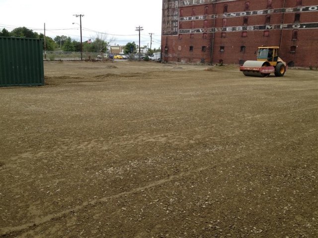
The 1.2-acre Former Universal Steel site is located in Salem, Massachusetts. From 1936 to 1998, metal recycling and reclamation activities took place on the site property. Activities included processing scrap metals and demolition debris, dismantling and processing transformers, and stockpiling automotive batteries. These activities contaminated site soil. EPA, the city of Salem, MassDevelopment and the Massachusetts Department of Environmental Protection worked together to clean up the site. Cleanup activities included excavation and off-site disposal of contaminated soil and debris, collection and disposal of lubrication oil, asbestos removal, and building demolition. FW Webb, a plumbing supply company, is buying the site property. FW Webb plans to use the property for parking, loading and storage as part of an 8,000-square-foot addition to an existing facility next door.
Last updated September 2024
As of December 2025, EPA did not have economic data related to on-site businesses, or economic data were not applicable due to site use. For additional information click here.
For more information:
W.R. GRACE & CO., INC. (ACTON PLANT)
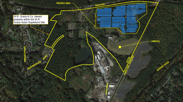
The 260-acre W.R. Grace & Co., Inc. (Acton Plant) Superfund site is in the towns of Acton and Concord in Massachusetts. For over 100 years, different companies ran a chemical manufacturing facility on-site. W.R. Grace, the last site owner, ceased all operations in 1991. Facility operators created wastewater and solid industrial wastes and disposed of them in several unlined lagoons and an on-site landfill. These practices contaminated soils, groundwater, surface water and sediments. In 1978, investigations found contamination in two municipal wells in Acton. The EPA directed W.R. Grace to begin interim cleanup actions at the site. The EPA added the site to the National Priorities List (NPL) in September 1983. Interim cleanup actions included groundwater extraction and treatment and removal of hazardous storage tanks. Final cleanup actions included landfill and lagoon closure, excavation of soils and sludges, sediment dredging and removal, capping of the on-site landfill, more groundwater extraction and treatment, and restoration of wetlands. The EPA’s Superfund Redevelopment Program and Region 1 assessed the site in 2010 as part of an effort to evaluate opportunities for using Superfund sites in Massachusetts for solar energy. After the remedy was in place, the town of Concord took ownership of a 70-acre parcel in 2016. The first phase of Concord’s three-phase reuse plan involved the construction of a 5.6-megawatt solar array. Construction finished in early 2017. This project added more green, competitively priced energy to the town's power supply portfolio. It supplies up to 4.5% of the town's power supply needs, enough to power 625 homes. The solar array reduces greenhouse gas emissions and offsets the town's peak demand for electricity by up to 10%. The second phase of Concord’s reuse plan, the construction of a school bus depot at the site, finished in August 2017. Additional solar capacity is being planned for the area between the industrial landfill and the rail tracks on the WR Grace property. Construction is anticipated in 2024.
Last updated September 2024
As of December 2025, EPA had data on 10 on-site businesses. These businesses employed 39 people and generated an estimated $8,866,283 in annual sales revenue. For additional information click here.
For more information:
- Site Redevelopment Profile: W.R. Grace & Co., Inc. (Acton Plant) Superfund Site (PDF)
- Superfund Site Profile Page
WELLS G&H

The Wells G&H Superfund site includes 330 acres of land and contaminated groundwater in Woburn, Massachusetts. It includes commercial, industrial and residential areas. Past operations at the site include dry cleaning, solvent storage, truck terminals, drum disposal, food wrap equipment manufacturing, and plastics manufacturing. In 1979, Massachusetts Department of Environmental Protection (MassDEP) found significant levels of hazardous chemicals in two municipal supply wells, known as wells G and H. MassDEP closed the wells. The EPA added the site to the Superfund program’s National Priorities List (NPL) in 1983. Cleanup included treatment of contaminated soils, excavation and disposal of debris and mixed contaminated soil, and extraction and treatment of source-area groundwater, as well as removal of contaminated sediment and restoration. Cleanup is ongoing. In 2000, the EPA’s Superfund Redevelopment Program awarded the Woburn city government a pilot grant to complete a comprehensive land use plan for the site. Three of the site’s responsible parties contributed additional funding for the effort. The land use plan identified reuse scenarios for three priority site areas: the Aberjona Auto Parts property, the city of Woburn property and the W.R. Grace property. The reuse scenario for the Aberjona Auto Parts property focused on an ice arena for local hockey leagues. Construction of the Holland Arena finished in 2008. The property owner also leases parts of the property to small businesses. The reuse scenario for the city of Woburn property identified public open space and passive recreation. The Aberjona Nature Trail was constructed along the Aberjona River and opened to the public in 2017. The reuse scenario for the W.R. Grace property focused on commercial uses and a hotel. The first restaurant opened there in 2016. Three years later, two more restaurants, a 110 Grill and Chick-Fil-A, and two hotels, a Homewood Suites and Hampton Inn, opened. A rooftop solar array started operating at the UniFirst commercial property on-site in 2021. At full capacity, it generates 310 kilowatts of energy.
Last updated September 2024
As of December 2025, EPA had data on 305 on-site businesses. These businesses employed 2,484 people and generated an estimated $564,863,154 in annual sales revenue. For additional information click here.
For more information:
- Site Redevelopment Profile: Wells G&H Superfund Site (PDF)
- Reuse and the Benefit to Community Wells G&H Superfund Site (PDF)
- Superfund Site Profile Page