U.S. flag

An official website of the United States government

Here’s how you know

Dot gov

Official websites use .gov
A .gov website belongs to an official government organization in the United States.

HTTPS

Secure .gov websites use HTTPS
A lock (LockA locked padlock) or https:// means you’ve safely connected to the .gov website. Share sensitive information only on official, secure websites.

    • Environmental Topics
    • Air
    • Bed Bugs
    • Chemicals and Toxics
    • Climate Change
    • Emergency Response
    • Environmental Information by Location
    • Environmental Justice
    • Greener Living
    • Health
    • Land, Waste, and Cleanup
    • Lead
    • Mold
    • Pesticides
    • Radon
    • Science Topics
    • Water Topics
    • A-Z Topic Index
    • Laws & Regulations
    • By Business Sector
    • By Topic
    • Compliance
    • Enforcement
    • Guidance
    • Laws and Executive Orders
    • Regulations
    • Report a Violation
    • Environmental Violations
    • Fraud, Waste or Abuse
    • About EPA
    • Our Mission and What We Do
    • EPA Administrator
    • Headquarters Offices
    • Regional Offices
    • Labs and Research Centers
    • Planning, Budget, and Results
    • Organization Chart
    • EPA History
    • Staff Directory
Environmental Modeling Community of Practice
Contact Us

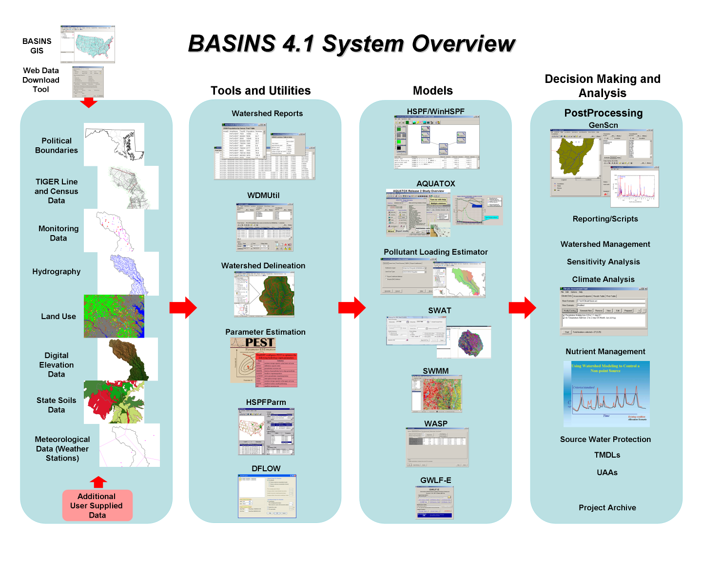
What's Changed Between BASINS 4.0 and 4.1?

Highlights
  • BASINS Home
  • What's Different about BASINS 4.1?
  • Framework and Features
  • User Information and Guidance
  • Download and Installation
  • Meterological Data
  • Metadata

BASINS 4.1 (released in 2013) provides a number of significant improvements over BASINS 4.0. These improvements increase the functionality and applicability of BASINS. The major changes that have been incorporated into BASINS 4.1 are listed below. For more detail on BASINS 4.1, please refer to the BASINS 4.1 User Manual (zip) (25.39 MB, 2013) .


Significant Improvements:

  • BASINS 4.1 is built upon the latest stable release of the non-proprietary, open-source MapWindow GIS. The new MapWindow interface has changed in appearance from BASINS 4.0, but the main functions remain the same.
  • The BASINS automatic watershed delineation tools have been updated to use TauDEM (Terrain Analysis Using Digital Elevation Models) version 5 from Utah State University. TauDEM is a software program that delineates watershed boundaries from topographic information such as elevation grids, slope and stream flow direction.
  • Beginning with BASINS 4.1, two of the main utilities, GenScn and WDMUtil, are available as separate downloads. However, most of the functionality of GenScn and WDMUtil is now included in the core BASINS user interface, making the separate programs unnecessary for most users.
  • BASINS 4.1 includes DFLOW, a tool to estimate design stream flows for use in water quality studies.
  • The BASINS 4.1 User Manual has been updated to reflect the current software.
  • Verified 64-bit and Windows 8 compatibility.
Screen image of BASINS 4.1 System Overview
The BASINS 4.1 system allows the user to process data through a variety of tools and utilities, run models, and analyze the data and results to facilitate informed decision making.

  • Environmental Modeling Community of Practice Home
  • Modeling Products
  • Groundwater Models
  • Surface Water Models
  • Food Chain Models
  • Multimedia Models
  • TMDL Models and Tools
  • Data Provisioning and Modeling Tools
  • Information Sources
Contact Us to ask a question, provide feedback, or report a problem.
Last updated on August 31, 2022
United States Environmental Protection Agency

Discover.

  • Accessibility Statement
  • Budget & Performance
  • Contracting
  • EPA www Web Snapshot
  • Grants
  • No FEAR Act Data
  • Plain Writing
  • Privacy
  • Privacy and Security Notice

Connect.

  • Data.gov
  • Inspector General
  • Jobs
  • Newsroom
  • Open Government
  • Regulations.gov
  • Subscribe
  • USA.gov
  • White House

Ask.

  • Contact EPA
  • EPA Disclaimers
  • Hotlines
  • FOIA Requests
  • Frequent Questions

Follow.