
Rest of River of the GE-Pittsfield/Housatonic River Site
- Administrative Record
- Appeals & Related Documents
- Baseline Monitoring Plan
- Biota Consumption Advisories
- Dam Inspections and Related Documents
- Fact Sheets and Other Informational Materials
- Reach 5A Sampling and Assessment Documents
- Reach 6/Woods Pond Sampling and Remedial Action
- Rest of River Site Wide Documents
- Rest of River QAPPs/SOPs/HASPs
- Statement of Work/Overall Strategy and Schedule
- Transportation and Disposal
- Upland Disposal Facility
Overview of the Rest of River
What is the "Rest of River"?
The term "Rest of River" is used in the Consent Decree to describe the third segment, or reach, of the River to be remediated in the Decree. The Rest of River covers nearly 125 miles from the confluence of the East and West Branches of the River in Pittsfield to the end of Reach 16 just before Long Island Sound in Connecticut.
In the Decree, GE and EPA agreed to a process for data-gathering, analysis of alternatives, decision-making and cleanup of Rest of River.
Rest of River Cleanup Process: Investigation, Analysis, Decision-Making and Cleanup
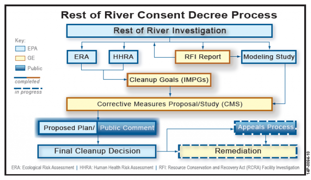
The chart immediately above provides major milestones in the Rest of River process. Below is a description of each step and its approximate timeframe, as well as link(s) to relevant documents.
- RCRA Facility Investigation Report (RFI Report): 1998-2003, Large-scale sampling of sediment, floodplain soil, and biota was undertaken in Rest of River, and provided information for EPA's Rest of River risk assessments and modeling efforts. PCB concentrations as high as 668 ppm have been found in sediment, 874 ppm in floodplain soil. GE submitted a RCRA Facility Investigation Report in September 2003, which includes the sampling data gathered to that point. See the following link for the RCRA Facility Investigation Report and related documents: https://semspub.epa.gov/src/collection/01/SC30256
- Ecological Risk Assessment (ERA), 2002-2004: EPA completed an initial risk assessment on ecological risks posed by the PCB contamination in 2003. Following that, EPA, submitted the ERA to independent peer review by a panel of scientists. Following the peer review, as well as public input from GE and other stakeholders, EPA revised the ERA and submitted a final report in November 2004. See the following link for the Ecological Risk Assessment Reports and related documents: https://semspub.epa.gov/src/collection/01/SC30232
- Human Health Risk Assessment (HHRA), 2002-2005: EPA completed an initial risk assessment on human health risks posed by the PCB contamination in 2003. Following that, EPA submitted the HHRA to independent peer review by a panel of scientists. Following the peer review, as well as public input from GE and other stakeholders, EPA revised the HHRA and submitted a final report in February 2005. See the following link for the Human Health Risk Assessment Reports and related documents: https://semspub.epa.gov/src/collection/01/SC30238
- Modeling Study, 2000-2006: EPA developed a numerical model of PCB fate and transport in the River, completing three reports: Modeling Framework Design report; Modeling Calibration report; and Modeling Validation report. EPA subjected each of the three reports to independent scientific peer review, as well as receiving public input from GE and other stakeholders. Following the peer reviews, EPA completed its modeling studies in November 2006. See the following link for the modeling reports and related documents: https://semspub.epa.gov/src/collection/01/SC30254
- Cleanup Goals (IMPGs), 2005-2006: GE submitted for EPA approval an initial and revised Interim Media Protection Goals reports, which provided the preliminary cleanup goals for Rest of River. EPA solicited comments on both of these reports. EPA conditionally approved the revised IMPGs report on April 3, 2006. See the following link for the Interim Media Protection Goals reports and related documents: https://semspub.epa.gov/src/collection/01/SC30253
- Corrective Measures Study (CMS) Proposal/Report, 2007-2010: GE submitted a CMS Proposal in 2007, and following approval, submitted a CMS Report to EPA. Following EPA and State comments, GE submitted a Revised CMS Report in 2010. See the following links for the Corrective Measures Study reports and related documents: https://semspub.epa.gov/src/collection/01/SC30231 and https://semspub.epa.gov/src/collection/01/SC30230
- EPA/GE/Massachusetts/Connecticut Remedy Discussions: In 2011, upon review of the Revised CMS, EPA solicited input from stakeholders and presented a proposed cleanup approach to EPA's National Remedy Review Board (NRRB) and the Contaminated Sediments Technical Advisory Group (CSTAG). See https://semspub.epa.gov/src/collection/01/SC30257 Following the initial meeting with NRRB/CSTAG in July 2011, EPA, Massachusetts and Connecticut held technical cleanup discussions in 2011-12, culminating in EPA's issuance of a status report on potential remediation approaches in May 2012 (pdf) . At GE's request, EPA then held technical discussions with GE from July 2012-December 2013 prior to issuing a proposed remedy. For a summary of the discussions, see the following: https://semspub.epa.gov/src/collection/01/SC30227
- Proposed Plan, 2014: In June 2014, EPA issued for public comment a Draft RCRA Permit Modification and Statement of Basis that included EPA's cleanup proposal. EPA accepted public comments until October 27, 2014, receiving over 2000 pages of comments from 140 commenters. For documents related to the proposed plan and the public comments see: https://semspub.epa.gov/src/collection/01/SC30225
- Dispute Resolution, 2015-2016: Following review of the public comments, and per the Consent Decree, EPA provided GE with its Intended Final Decision, with an opportunity to seek dispute resolution. GE disputed the intended cleanup. On October 13, 2016, an EPA dispute resolution official decided the dispute. See https://semspub.epa.gov/src/collection/01/SC32124
- Final Permit Modification, 2016: Following conclusion of the dispute resolution process, EPA issued a Final RCRA Permit Modification to select its Rest of River remedy. This included a formal Response to Comments on the Draft permit. See: https://semspub.epa.gov/src/collection/01/SC34907
- Appeals Process, 2016-present: EPA's October 2016 Final Permit Modification was appealed to the EPA Environmental Appeals Board (EAB) by five parties: GE, the Housatonic River Initiative, C. Jeffrey Cook, the Rest of River Committee (of the towns of Lenox, Lee, Sheffield, Stockbridge, and Great Barrington), and the Berkshire Environmental Action Team. Additionally, the States of Massachusetts and Connecticut are part of the EAB proceeding, as well as four amicus parties: Mass Audubon, City of Pittsfield, Green Berkshires, Inc., and the Rest of River Municipal Committee. All the parties submitted written briefs to the EAB, and all but Mass Audubon and BEAT participated in the EAB's June 2017 oral argument.
The EAB issued its decision on January 26, 2018. The EAB denied the appeals of the parties on all issues related to the extent of the cleanup. Additionally, the EAB remanded for further consideration by EPA two issues: the limitations placed on GE's responsibility to address PCB contamination related to projects or work performed by third parties, and the location of disposal of PCB-contaminated material excavated in the cleanup. - Rest of River Statement of Work (SOW)/Design Documents, 2017-present: EPA regulations allow that all requirements in a permit that are not contested and are severable from the contested permit conditions may go forward during appeals. EPA notified GE of these uncontested and severable requirements in January 2017. GE submitted a Rest of River Statement of Work in May 2017, which was subsequently conditionally approved by EPA. GE has submitted documents/plan required by the initial SOW and EPA is reviewing these documents. EPA is soliciting informal comments from stakeholders prior to approving these documents. See https://semspub.epa.gov/src/collection/01/SC35333
- Biota Consumption and Advisories: Both Massachusetts and Connecticut have issued biota consumption advisories for the Rest of River. In Massachusetts, this includes an advisory on fish, ducks, frogs and turtles. In Connecticut, it includes fish and ducks. GE, with EPA Oversight, is responsible for monitoring and maintaining biota advisory signage developed by Massachusetts and Connecticut and distributing informational materials to licensing facilities. If you believe there is need for signage within the Rest of River, please provide those details to R1Housatonic@epa.gov.
Rest of River Next Steps
- The appeal process was completed in October 2023 and the Federal Court upheld the EPA permit.
- Continue with the submittal and review process for SOW/design documents for uncontested portions of the cleanup. See the following for SOW/design-related documents: https://semspub.epa.gov/src/collection/01/SC35333
- Continue with support for the biota consumption advisories, including the inspection and replacement of warning signs. See the following link for biota consumption advisories and related documents: https://semspub.epa.gov/src/collection/01/SC30224
Reports for the Rest of River
- 2020 Rest of River Revised Final Permit, Selection of Remedial Action and Response to Comments
- Rest of River Draft 2020 Permit Modification/Proposed Remedial Action, Supporting Documentation, and Public Comment
- Rest of River Draft 2020 Permit Mod/Proposed Remedial Action, Voicemail Comments
- Rest of River 2020 Settlement Agreement
- Settlement Agreement (pdf)
- Fact Sheet: Agreement in Principle (pdf)
- Statements from Parties to Agreement
- Rest of River Statement of Work (SOW)/Design Documents
- 2016 Rest of River Final Permit Modification, Selection of Remedial Action and Response to Comments
- Intended Final Decision on Rest of River Cleanup Plan and Related Correspondence
- Rest of River Biota Consumption Advisories
- Rest of River Proposed Remedial Action, Supporting Documentation, and Public Comment
- Rest of River Discussions between Government Agencies and GE conducted from 8/2012 through 12/2013
- Rest of River Community Updates
- Rest of River Corrective Measures Studies and Public Comments
- Rest of River Corrective Measures Study Proposal and Public Comments
- Rest of River Ecological Risk Assessment Documents, Peer Review and Public Comments
- Additional Rest of River Documents and Correspondence
- Rest of River Human Health Risk Assessment Documents, Peer Review and Public Comments
- Rest of River Interim Media Protection Goals Documents and Public Comments
- Rest of River Modeling Documents, Peer Review and Public Comments
- Rest of River RCRA Facility Investigation Report and Related Investigation Documents
- Rest of River Remedy Review Board Documents
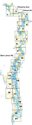
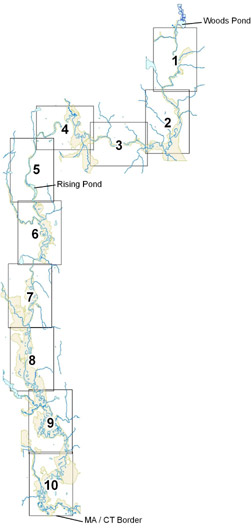
Maps and Figures for the Rest of River
These figures represent a visualization of PCB concentrations in soils and sediments of the Housatonic River and floodplain between Pittsfield and Lenox, Massachusetts as determined from data collected by EPA and others prior to September 20, 2000 and are subject to revision based on subsequent data collection and assessment.
Figures:
Maps:
Total PCB Results for
Reaches 5 & 6
Total PCB Results for Reaches 7, 8, & 9


 Floodplain")
 Floodplain")
")


 egg mass")
")
")


")
")
")
")
")


