U.S. flag

An official website of the United States government

Here’s how you know

Dot gov

Official websites use .gov
A .gov website belongs to an official government organization in the United States.

HTTPS

Secure .gov websites use HTTPS
A lock (LockA locked padlock) or https:// means you’ve safely connected to the .gov website. Share sensitive information only on official, secure websites.

    • Environmental Topics
    • Air
    • Bed Bugs
    • Cancer
    • Chemicals, Toxics, and Pesticide
    • Emergency Response
    • Environmental Information by Location
    • Health
    • Land, Waste, and Cleanup
    • Lead
    • Mold
    • Radon
    • Research
    • Science Topics
    • Water Topics
    • A-Z Topic Index
    • Laws & Regulations
    • By Business Sector
    • By Topic
    • Compliance
    • Enforcement
    • Laws and Executive Orders
    • Regulations
    • Report a Violation
    • Environmental Violations
    • Fraud, Waste or Abuse
    • About EPA
    • Our Mission and What We Do
    • Headquarters Offices
    • Regional Offices
    • Labs and Research Centers
    • Planning, Budget, and Results
    • Organization Chart
    • EPA History

Breadcrumb

  1. Home
  2. Impaired Waters and TMDLs

Impaired Waters and TMDLs in the Southeast - Region 4
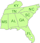
Map of Region 4

Region 4 serves Alabama, Florida, Georgia, Kentucky, Mississippi, North Carolina, South Carolina, Tennessee and 6 Tribes.

The EPA Regional Program reviews and approves or disapproves the states' 303(d) lists, and reviews and approves or disapproves state-submitted Total Maximum Daily Loads (TMDLs).

In some cases, EPA also develops TMDLs for impaired waters. EPA-developed TMDLs are posted by state. The public notice for the proposed TMDL, the proposed TMDL document and final TMDL are posted by watersheds for each state.

Public Notices in Region 4
There are no public notices at this time.

Recent Actions

Impaired Waters Rule Decision Documents

  • The Florida Impaired Waters Rule establishes a methodology to identify waters that will be included on the State's Clean Water Act Section 303(d) list of impaired waters.

Floyds Fork TMDL Development (Louisville, KY)

EPA Region 4 and the Kentucky Division of Water (KDOW) are developing a TMDL for the Floyds Fork watershed.

TMDL Development Tools

EPA utilizes and develops modeling tools for the development of Total Maximum Daily Loads (TMDLs). These tools vary from simple spreadsheets to dynamic models. It is EPA's goal to make these tools and training on these tools available to our partner states and other interested parties. The Watershed and Water Quality Modeling Technical Support Center maintains and distributes models and tools used for the development of TMDLs.

Region 4 Contacts

EPA and State Contacts

Impaired Waters and TMDLs

  • Program Vision
  • Impaired Waters and TMDLs throughout the U.S
  • Technical Tools and Resources
Contact Us About Impaired Waters and TMDLs
Contact Us to ask a question, provide feedback, or report a problem.
Last updated on November 26, 2024
  • Assistance
  • Spanish
  • Arabic
  • Chinese (simplified)
  • Chinese (traditional)
  • French
  • Haitian Creole
  • Korean
  • Portuguese
  • Russian
  • Tagalog
  • Vietnamese
United States Environmental Protection Agency

Discover.

  • Accessibility Statement
  • Budget & Performance
  • Contracting
  • EPA www Web Snapshot
  • Grants
  • No FEAR Act Data
  • Plain Writing
  • Privacy
  • Privacy and Security Notice

Connect.

  • Data
  • Inspector General
  • Jobs
  • Newsroom
  • Regulations.gov
  • Subscribe
  • USA.gov
  • White House

Ask.

  • Contact EPA
  • EPA Disclaimers
  • Hotlines
  • FOIA Requests
  • Frequent Questions
  • Site Feedback

Follow.