
EPA Research in Florida
EPA researchers are working hard to protect communities across the nation. Learn about some of the work EPA researchers are doing in Florida.
- Helping Community Drinking Water Systems Find Cost-Effective Solutions to Treatment Challenges
- Research for Tampa Bay
- Real-Time Water Distribution System Analysis
- Communicating Technical Guidance for Safely Remediating Flooded Homes
- Effects of Microplastics on Atlantic Stony Corals
- Assessing Sediment Habitat Quality using Novel Remote Sensing Technologies
- Arsenic Bioavailability in Contaminated Creek Sediment
EPA Research in Florida’s Pensacola and Perdido Bays
- Monitoring the Health of the Perdido Bays Estuary
- Studying tire-derived pollutants in stormwater
- Conducting hydrodynamic & water quality modeling study
- Assisting with National Coastal Condition Assessment intensification survey
- Evaluating effectiveness of fecal indicator test methods in marine, estuarine & freshwater systems
- Using Environmental DNA methods to learn about aquatic species & habitats
- Evaluating community vulnerability & resilience in Florida watersheds
- Using periodic counts to estimate coastal estuary recreational use
For more EPA work, see EPA in Florida.
Helping Community Drinking Water Systems Find Cost-Effective Solutions to Treatment Challenges
Emerging contaminants, such as per- and polyfluoroalkyl substances (PFAS), are challenging to drinking water systems across the country. Effective treatment for emerging contaminants can be unknown, difficult, and extremely costly. EPA researchers are providing technical assistance to a large community water system with PFAS concerns to help them identify optimal, cost-effective treatment methods and optimize the long-term operation of their chosen technology. These efforts will also be used to develop best practices and performance and cost estimate tools so water utilities across the country can make informed treatment and operational choices.
Research for Tampa Bay

Scientists in EPA's Office of Research and Development (ORD) have been working with the Tampa Bay Estuary Program for more than 20 years to help protect the water quality, habitat and benefits provided by Tampa Bay, Florida’s largest open water estuary. Projects have covered a wide range of subjects, including nutrient assessment and monitoring, aquatic habitats, assessing the benefits (ecosystem services) that the estuary provides, and setting management targets for recovery and restoration. In one innovative project, EPA researchers used historic data to document and illustrate the loss of seagrass habitat over time, then worked with local partners to set seagrass restoration targets. Learn more about this work.
Real-Time Water Distribution System Analysis
EPA's tool EPANET-RTX gives water utilities the necessary tools to enhance system operations including emergency response and improved operations such as better pressure management, leak detection and water quality. EPANET-RTX has been tested or demonstrated in several locations including Ohio, Colorado, Florida, Kentucky, and Michigan.
Communicating Technical Guidance for Safely Remediating Flooded Homes
ORD, in collaboration with EPA Region 4, created an innovative risk communication strategy to produce materials targeted to people impacted by flooding. EPA and partners interviewed residents of Florida and other states who had recently experienced flooding due to Hurricanes Dorian, Michael, and Irma. The researchers then created a website tailored to homeowners, renters and volunteers working to fix up flooded homes: Flooded Homes Cleanup Guidance.
Effects of Microplastics on Atlantic Stony Corals
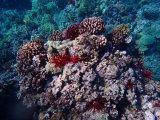
ORD conducted laboratory studies to determine the size of microplastics that corals can ingest, if microplastics are retained once ingested, and the long- and short term effects on growth. Coral and water samples were collected from Florida’s coral reef. Findings can be used to know the potential and actual risks of microplastics on coral, determine potential sources of microplastic pollution, and to implement improved management applications to minimize microplastic exposure to coral.
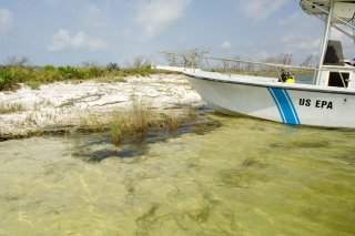
Assessing Sediment Habitat Quality Using Novel Remote Sensing Technologies
Bayou Chico in Escambia County, Florida, is an urban estuary and is considered one of the most historically contaminated water bodies in the state. Despite efforts to improve surface water quality, sediments remain impacted by fecal coliform bacteria, excess nutrients, and legacy contaminants. ORD scientists, in collaboration with EPA Region 4, deployed the Sediment Profile Imaging (SPI) camera system in Bayou Chico. Sediment and biological features that can be identified in the imagery will be evaluated to identify possible relationships between these measures and known stress gradients in the Bayou.
Arsenic Bioavailability in Contaminated Creek Sediment
ORD, in collaboration with EPA Region 4, collected Arsenic-contaminated sediments from the on-site retention pond and along a creek near the Fairfax Street Wood Treaters facility, a Superfund site in Jacksonville. Elevated levels of arsenic in the pond and creek were detected. Once detected, researchers performed toxicity tests and analysis of bacterial community composition. The results showed that EPA Method 1340 could be developed for ecological risk assessments. The results from sampling also helped to show As in the sediments did not pose an ecological risk.
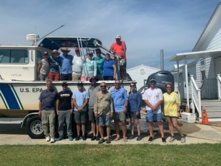
Monitoring the Health of the Perdido Bays Estuary
ORD, in collaboration with EPA Region 4, worked with the Pensacola and Perdido Bays Estuary Program (PPBEP) team to develop and implement a probabilistic sampling strategy. Water, sediment, fish measurements, and samples were taken and analyzed for pollutant, toxicity, and biological characteristics. EPA staff provided the technical support for the survey design, training, field logistics and sample collection. The results will serve as a baseline for the PPBEP to monitor progress in restoring and maintaining the resilience of the Pensacola and Perdido Bays and the community benefits derived from healthy productive estuaries.
Partnering with Florida’s Escambia County to Study Tire-Derived Pollutants in Stormwater
During spring 2023, EPA scientists began investigating how tire particles and pollutants travel from the source, like a roadway, through stormwater retention ponds and into tidal (estuarine) ecosystems depending on traffic, weather conditions, and filtration systems. The study results will help design better stormwater treatment facilities and create healthier natural environments in surrounding communities. This research is being conducted in collaboration with Escambia County.
Conducting Hydrodynamic and Water Quality Modeling Study
EPA researchers, in collaboration with PPBEP, are conducting a hydrodynamic and water quality modeling project in Pensacola Bay between 2022-2026. The study results will help improve water quality simulation models used for estuaries at risk from human activities and global climate change. The information will also help scientists better understand what physical conditions and biological controls change oxygen and pH levels in water, as well as the impact of human activities on water quality throughout the estuary.
Assisting with National Coastal Condition Assessment Intensification Survey in Florida’s Pensacola and Perdido Bays
When Florida’s PPBEP began a long-term environmental monitoring program in 2021, EPA researchers helped them develop and use an environmental monitoring strategy called probabilistic sampling. Using protocols established under EPA’s National Coastal Condition Assessment (NCCA), scientists collected water, sediment, and fish samples and measurements and analyzed them for pollutants, toxicity, and biological characteristics. EPA staff also provided technical support for survey design, training, field logistics, and sample collection. PPBEP uses the sampling results as a baseline as they monitor progress in restoring and maintaining the resilience of Pensacola and Perdido Bays and the benefits local communities gain from healthy estuaries. This research was conducted in collaboration with Escambia County and the Florida Fish and Wildlife Conservation Commission.
Evaluating Effectiveness of Fecal Indicator Test Methods in Marine, Estuarine, and Freshwater Systems
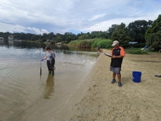
From spring of 2021 until summer 2022, EPA researchers sampled three sites with different salinity levels (marine, estuarine and freshwater) in the Pensacola Bay watershed to test fecal indicator methods. Once a week, researchers collected water from each site and took water- quality measurements. Back in the lab, EPA researchers combined water samples by site and analyzed them for fecal indicator bacteria (E. coli and enterococci) and coliphages (specific viruses found in human feces). Results from this study will help determine which test methods best support EPA’s Recreational Water Quality Criteria and Coliphage Criteria with the intent of providing tools that can be used by federal, regional, and state laboratories and tribes to assess fecal-impacted watersheds.
Using Environmental DNA Methods to Learn About Aquatic Species and Habitats
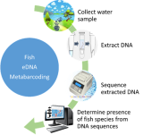
Living organisms constantly shed and excrete DNA into the environment. This environmental DNA (eDNA) can be easily collected from water or sediment samples and used to identify organisms that live in or periodically visit our waters. This process is called eDNA metabarcoding, and is a low effort, lesser impact, and more accurate way to identify fish and invertebrate species in specific locations. This research will help determine if eDNA metabarcoding is a useful tool to describe fish and invertebrate diversity in estuaries; help establish when, where, and how many organisms are found; and help create a DNA library for the local area. This research is being conducted in collaboration with PPBEP and The Nature Conservancy. Read the Science Matters Story, "How EPA Scientists Use Fish eDNA to Assess Estuarine Health."
Evaluating Community Vulnerability and Resilience in Florida Watersheds
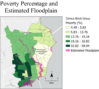
EPA scientists have developed methods and models to evaluate local access and vulnerability measures within Florida’s Pensacola and Perdido Bay watersheds. Local access includes parks, grocery stores, medical facilities, museums, libraries, and other community amenities that would improve well-being through social, cultural, or recreational activities. Vulnerabilities are potential hazards-either natural, like hurricanes, tornados, and floods- or technological, like superfund sites or facilities that emit hazardous air or water pollution.
Results from these analyses are included in the PPBEP Comprehensive Conservation and Management Plan to help outline and meet objectives for assessing social vulnerabilities of communities under a changing climate. This research was conducted in collaboration with the PPBEP and Escambia County.
Using Periodic Counts to Estimate Coastal Estuary Recreational Use
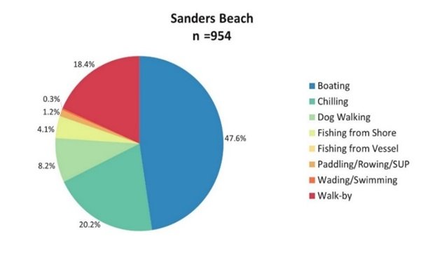
In 2022, EPA researchers observed visitation at two sites — Sanders Beach and Bayview Park — in Pensacola to learn more about coastal estuary recreational use in northwest Florida. The observational surveys aimed to test the transferability of a method for using periodic counts to estimate public recreational use. The sites were also part of EPA sanitary surveys, which examine water quality but also count the number of people using the area at the time. The surveys help state and local program managers and public health officials identify sources of water pollution, assess its severity, and prioritize locations for water testing. This research was conducted in collaboration with PPBEP.