NHDPlusV1 Puerto Rico & US Virgin Islands Data

Puerto Rico & US Virgin Islands (Hydrologic Region 21)
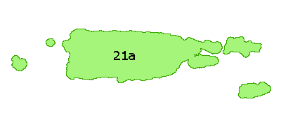
The Puerto Rico & US Virgin Islands drainage area is composed of hydrologic region 21.
The Puerto Rico & US Virgin Islands hydrologic region is further identified by production unit: 21a.
NHDPlus Shapefile and DBF components are distributed by hydrologic region.
NHDPlus ESRI Grid components are distributed by production units.
For more information please see Puerto Rico & US Virgin Islands Release Notes (DOC)(2 pp, 28 K) or Puerto Rico & US Virgin Islands Release Notes (PDF) (2 pp, 11 K, About PDF).
The following links exit the site
NHDPlusrrVnn_componentname.zip
where:
- rr is the hydrologic region number
- nn is the currently available version of the data
- componentname describes the content of the zip file
| File Description | File Name (.zip) | Format |
|---|---|---|
| Region 21, Version 01_04, Catchment Grid | NHDPlus21V01_04_Catgrid | ESRI Grid |
| Region 21, Version 01_01, Catchment Shapefile | NHDPlus21V01_01_Catshape | Shapefile |
| Region 21, Version 01_02, Catchment Flowline Attributes | NHDPlus21V01_02_Cat_Flowline_Attr | DBF |
| Region 21, Version 01_02, Elevation Unit a | NHDPlus21V01_02_Elev_Unit_a | ESRI Grid |
| Region 21, Version 01_02, Flow Accumulation and Flow Direction Unit a | NHDPlus21V01_02_FAC_FDR_Unit_a | ESRI Grid |
| Region 21, Version 01_05, National Hydrography Dataset | NHDPlus21V01_05_NHD | Shapefile and DBF |
| Region 21, Version 01_01, QAQC & Sinks Spreadsheet | NHDPlus21V01_01_QAQC_Sinks | Excel Spreadsheet |
| Region 21, Version 01_01, Stream Gage Event | NHDPlus21V01_01_StreamGageEvent | DBF |
