
Viewing WATERS Data using Google Earth
Description
The WATERSKMZ Tool is a compressed Keyhole Markup Language (KML) file that provides easy access to geospatial WATERS data and services. The current release of the tool requires the use of Google Earth version 7.3 or higher.
To get started using the WATERSKMZ Tool visit the WATERSKMZ tutorial.
Download
| Download |
|---|
(Updated 02-25-2026) |
Interface Overview
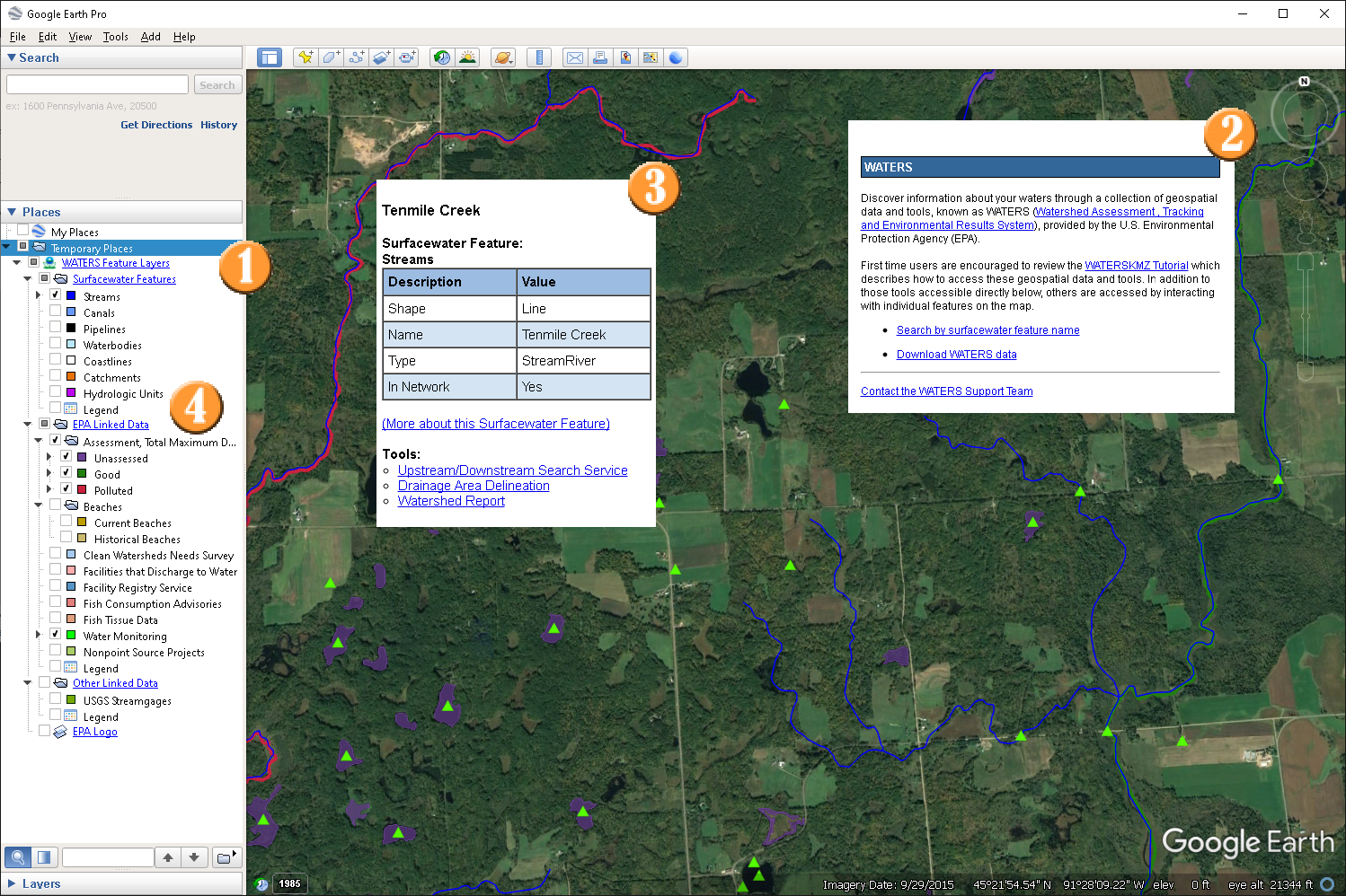
| Feature | |
|---|---|
| Access to framework geospatial datasets stored in WATERS, such as NHDPlus, Water Program Features indexed to NHDPlus and to general purpose services. | |
| Dialog boxes providing access to tools, services, and information, such as NHDPlus feature name query, upstream & downstream navigation, water quality reports. | |
| Access to indexed water program features, with hyperlinks to additional attributes, and context sensitive analysis services, such as upstream & downstream navigation and watershed reports. | |
| Full descriptive legend showing layer symbology. |
Available Data
WATERS
- NHDPlus v2.1 Features
- NHDPlus v2.1 Catchments and Geofabric
- NHDPlus v2.1 Watershed Boundary Dataset (WBD)
- EPA Linked Data
- Assessment, Total Maximum Daily Load Tracking and Implementation System
- Beaches
- Clean Watersheds Needs Survey
- Facilities that Discharge to Water
- Facility Registry Service
- Monitoring Locations
- Other Linked Data
- USGS Streamgages
Notes
- Some tools and reports are only available for certain features types (points, lines, areas). i.e. The Upstream/Downstream Search Service and Navigation Delineation Tools are only available for line and point features indexed to NHDPlus flowline reaches.
Usage Notes
- The KMZ file is designed to work in version 7.3 or higher of Google Earth Desktop.
Terms of Use and Disclaimer
The user is responsible for reading and evaluating dataset limitations, restrictions, and intended use. For additional information, please see WATERS Terms of Use and Disclaimer.
Changelog
Version: 2.2 - Released: February 25, 2026
- File updated to remove Fish Consumption and Fish Tissue reach indexed data.
Version: 2.1 - Released: June 25, 2024
- File updated to remove EPA Nonpoint Source Projects reach indexed data.
Version: 2.0 - Released: September 20, 2022
- File updated to reference new mapping services providing new program information. This is a breaking change, users need to download this version to continue to work with the WATERSKMZ.
Version: 1.10 - Released: January 19, 2020
- File updated to reference new mapping service location. This is a breaking change, users need to download this version to continue to work with the WATERSKMZ.
Version: 1.9 - Released: December 15, 2017
- File updated to reference new mapping service location. This is a breaking change, users need to download this version to continue to work with the WATERSKMZ.
- The Streams and Catchments data set popups were updated to point to EPA’s revised Watershed Report. The revised report provides access to the StreamCat Dataset which currently provides summaries of 206 natural and anthropogenic landscape features for ~2.65 million streams, and their associated catchments, within the conterminous USA.
- USGS Streamgages were added as a new data set under the folder labelled “Other Linked Data”.
Version: 1.8 - Released: November 9, 2016
- KMZ file updated to reference new mapping service location. This is a breaking change, users need to download this version to continue to work with the WATERSKMZ.
Version: 1.7 - Released: October 13, 2015
- KMZ file updated to reference redesigned EPA web pages. This is not a breaking change for Google Earth functionality, but ensures that all referenced web pages link correctly.
Version: 1.6 - Released: February 5, 2014
- KMZ file updated to use new mapping server. This is a breaking change, users will need to download a new version of the KMZ files to use the tool.
- Removed references to decommissioned services and datasets.
- The Raster version of the WATERSKMZ Tool was decommissioned.
Vector & Raster Version: 1.5 - Released: June 23, 2013
- KMZ files updated to use new mapping server. This is a breaking change, users will need to download a new version of the KMZ files to use the tool.
Vector & Raster Version: 1.4 - Released: February 07, 2012
- Removed Water Quality Standards program from KMZ.
Vector Version 1.3 & Raster Version 1.2 - Released: November 24, 2010
- Added STORET Monitoring Locations to both versions of the WATERSKMZ.
- Added STORET Monitoring Locations to the Upstream/Downstream Search Service tool.
Raster Version: 1.1 - Released: September 30, 2010
- Added TMDLs on Impaired Waters to KMZ.
- Updated Water Program Features names to match Vector version.
Vector Version: 1.2 - Released: May 07, 2010
- Simplified terminology and structure.
- Symbology integrated into MyPlaces pane.
- Miscellaneous bubble improvements.
Vector Version: 1.1 - Released: November 13, 2009
- KMZ files now require Google Earth 5.0 or higher.
- The terminology used in the KMZ files was simplified.
- The KMZ service tools were simplified.
- A new Surfacewater Features legend was added.
Vector & Raster Version: 1.0 - Released: August 31, 2009
- Initial release of both Vector and Raster based KMZ files