
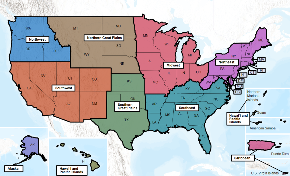
Climate Change Connections: North Carolina (Outer Banks)
Climate change is impacting all regions and sectors of the United States. The State and Regional Climate Change Connections resource highlights climate change connections to culturally, ecologically, or economically important features of each state and territory. The content on this page provides an illustrative example. As climate change will affect each state and territory in diverse ways, this resource only describes a small portion of these risks. For more comprehensive information about regional climate impacts, please visit the Fifth National Climate Assessment and Climate Change Impacts by Sector.
On this page:
Introduction: The Unique Barrier Islands of the Outer Banks Support Coastal Ecosystems and Economies
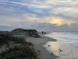
The Outer Banks are a chain of barrier islands along North Carolina’s coast.1 Barrier islands are sediment formations that naturally erode, grow, and migrate.2,3 Known for their beautiful beaches, rich maritime history, and unique wildlife, the Outer Banks are also home to numerous iconic landmarks. Jockey’s Ridge, North Carolina’s most-visited state park, boasts several features including the tallest active sand dune system on the East Coast.4,5 These dunes are considered “active” because, just like the barrier islands, the sand is constantly migrating.1,4 Cape Hatteras National Seashore, also part of the Outer Banks, is home to a mosaic of marshes, sandy beaches, and maritime forests that support rich biodiversity.3 For over two centuries, the Cape Hatteras lighthouse has helped aid vessels in avoiding the Diamond Shoals, where hazardous conditions, created by the merging of two major currents, can make navigation difficult.6,7 This area off the coast of Cape Hatteras has been described as the “Graveyard of the Atlantic” due to the estimated thousands of shipwrecks in the shifting sands.8
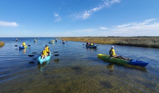
Unique natural features, seafood, and opportunities for activities such as windsurfing, fishing, and wreck diving make the Outer Banks a popular destination. Outer Banks tourism contributes significantly to the regional economy. Dare County, which encompasses much of the Outer Banks, is home to around 37,000 year-round residents.9 The barrier islands’ unique features that help make them so desirable for residents and visitors also make them vulnerable to erosion due to both human activities and the effects of climate change.2 Climate change driven sea level rise and more intense storm activity are expected to accelerate erosion and further threaten development along the Outer Banks.
Climate Impacts: Sea Level Rise Increases Flooding and Erosion
Over the last three decades, sea level rise has accelerated globally, threatening shores and coastal communities.10 The low elevation of North Carolina’s Outer Banks makes them particularly vulnerable to the impacts of sea level rise.11 Much of the land in the Outer Banks is sinking slowly in a process known as subsidence, which is increasing relative sea level rise. Relative sea level change refers to how the height of the ocean rises or falls relative to the land at a particular location.10,12 The frequently shifting sands of the barrier islands has historically made construction and maintenance of roads and buildings difficult.13 While development of the Outer Banks has allowed for more access, it increases vulnerability for people and infrastructure. Certain construction projects can degrade the naturally stabilizing dunes and vegetation that would otherwise mitigate some of the impacts of rising seas.14
By 2050, sea level in the Outer Banks is expected to rise 15 to 22 inches, higher than the projected global average.10 Higher sea levels can contribute to increased flooding, erosion, and storm surge.15 Storm surge describes abnormally high water levels during a storm. As sea level rises, high tide flooding is expected to occur more often and increase in severity.16 High tide flooding, also known as nuisance or sunny day flooding, takes place when water levels reach above the average high tide mark for a certain location.11,16 The term “sunny day flooding” is used because severe weather does not need to happen for these floods to occur.16 High tide flooding can be disruptive and expensive, threatening infrastructure not built to withstand exposure to water and salt.16 In the Southeast region of the United States, sea level rise may cause high tide flooding events to increase five- to tenfold by 2050.10
Beaches in the Outer Banks have been eroding at some of the fastest rates along the East Coast.17 This erosion is projected to continue to increase with sea level rise, and damage to beaches and infrastructure has already been observed.18,19 Debris from destroyed infrastructure can drift miles away from the original property site, disrupting wildlife habitats and threatening safety.19
Climate Impacts: Intense Storms Are Expected to Continue Affecting the Region
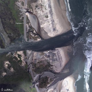
Located along the Atlantic Coast, the Outer Banks are exposed to hurricanes and nor’easters. In 2011, storm surge from Hurricane Irene, along with erosion, caused breaches in Highway 12 and moved sand onto roads and nearby marshes.20 In 2018, Hurricane Florence caused major devastation across the region, resulting in dozens of deaths and more than $17 billion in damages statewide.21 In addition to coastal impacts, hurricanes can bring heavy rainfall and cause major flooding further inland. For example, heavy precipitation during Hurricane Florence was linked to water contamination issues stemming from hog waste on farms in the eastern part of the state.10 Low-income communities and renters often face disproportionate flooding risks and more financial challenges in disaster recovery.10
Sea level rise is expected to intensify flooding from storm surge, which could worsen the damage caused by hurricanes and tropical storms in the Outer Banks.10 Although some of the impacts of climate change on hurricanes remain uncertain, more hurricanes in the North Atlantic are expected to become stronger, reaching at least Category 4 intensity.10 Beach dunes, grasses, and the barrier islands themselves act as a buffer for the mainland coast from storm surge, wave energy, and extreme weather.2,22 As sediment is pushed toward the sound and the barrier islands migrate, their ability to act as a buffer could decrease and leave the developed mainland coast more vulnerable to the impacts of storms.22
Taking Action: Living with a Changing Coastline
Addressing climate change requires reducing greenhouse gas emissions while preparing for and protecting against current and future climate impacts. Communities, public officials, and individuals in every part of the United States can continue to explore and implement climate adaptation and mitigation measures. In North Carolina, communities and planners are taking steps to prepare and respond to a changing coastline:
- Community resilience planning. As sea levels continue to rise, communities along the Outer Banks are collaborating to identify and implement resilience measures for current and projected flooding and erosion. In 2022, the town of Nags Head adopted a comprehensive resilience strategy that prioritized projects that manage risks from sea level rise and erosion, including living shoreline projects.23 The North Carolina Resilient Communities Program supports partnerships and provides resources for community-driven efforts for risk assessment and project prioritization to address coastal hazards. With the scale of erosion and projected sea level rise, some communities are weighing measures to limit construction in vulnerable areas and relocation.
- Living shorelines. As part of their Living Shorelines Project, the National Oceanic and Atmospheric Administration (NOAA), in partnership with primarily community-based restoration programs, continues to build living shorelines across the coast of North Carolina and around the United States.24,25 The term “living shoreline” captures a variety of techniques that use natural materials, such as vegetation, in combination with hard materials, such as sand or rock, to stabilize coastal edges and minimize erosion.26 Living shorelines can also improve water quality, increase biodiversity, and contribute to carbon sequestration.27 Other projects in the Outer Banks have included planting native salt marsh grass, constructing stone sills, creating oyster reefs, and installing vertical sheet pile sills to minimize erosion and stabilize the shoreline.26,28
To learn more about climate change impacts in North Carolina and the Southeast region, see Chapter 22 of the Fifth National Climate Assessment.
Related Resources
- EPA Climate Change Indicators: Sea Level
- EPA Climate Change Indicators: A Closer Look: Land Loss Along the Atlantic Coast
- Fifth National Climate Assessment: Chapter 9: Coastal Effects
- North Carolina State Climate Summary 2022 (NOAA)
References
1 U.S. Geological Survey. (n.d.). Cape Hatteras National Seashore. Geology and Ecology of National Parks. Retrieved January 26, 2024, from https://www.usgs.gov/geology-and-ecology-of-national-parks/cape-hatteras-national-seashore
2 NOAA National Ocean Service. (2021). What is a barrier island? Ocean Facts. Retrieved January 12, 2024, from https://oceanservice.noaa.gov/facts/barrier-islands.html
3 National Park Service. (n.d.). Learn about the park. Cape Hatteras National Seashore. Retrieved January 30, 2024, from https://www.nps.gov/caha/learn/index.htm
4 NC Division of Parks & Recreation. (n.d.). Jockey’s Ridge State Park. Retrieved January 26, 2024, from https://www.ncparks.gov/state-parks/jockeys-ridge-state-park
5 Official Tourism Authority for Dare County’s Outer Banks. (n.d.). Outer Banks attractions. The Outer Banks of North Carolina. Retrieved January 26, 2024, from https://www.outerbanks.org/things-to-do/attractions/
6 National Park Service. (n.d.). Cape Hatteras Light Station. Cape Hatteras National Seashore. Retrieved January 26, 2024, from https://www.nps.gov/caha/planyourvisit/chls.htm
7 U.S. Geological Survey. (n.d.). Geology of Cape Hatteras National Seashore. Geology and Ecology of National Parks. Retrieved February 1, 2024, from https://www.usgs.gov/geology-and-ecology-of-national-parks/geology-cape-hatteras-national-seashore
8 Weinberg, E. (2018). Maritime archaeologists document historic Graveyard of the Atlantic shipwrecks. National Marine Sanctuaries. Retrieved January 26, 2024, from https://sanctuaries.noaa.gov/news/nov18/maritime-archaeologists-document-history-graveyard-of-the-atlantic-shipwrecks.html
9 U.S. Census Bureau. (2023). QuickFacts: Dare County, North Carolina [Data set]. Retrieved August 6, 2024, from https://www.census.gov/quickfacts/fact/table/darecountynorthcarolina/PST045222
10 Hoffman, J. S., McNulty, S. G., Brown, C., Dello, K. D., Knox, P. N., Lascurain, A., Mickalonis, C., Mitchum, G. T., Rivers III, L., Schaefer, M., Smith, G. P., Camp, J. S., & Wood, K. M. (2023). Ch. 22. Southeast. In A. R. Crimmins, C. W. Avery, D. R. Easterling, K. E. Kunkel, B. C. Stewart, & T. K. Maycock (Eds.), Fifth National Climate Assessment. U.S. Global Change Research Program. https://doi.org/10.7930/NCA5.2023.CH22
11 Frankson, R., Kunkel, K. E., Stevens, L. E., Easterling, D. R., Sweet, W., Wootten, A., Aldridge, H., Boyles, R., & Rayne, S. (2022). North Carolina state climate summary 2022 (NOAA Technical Report NESDIS 150-NC). NOAA National Environmental Satellite, Data, and Information Service. https://statesummaries.ncics.org/chapter/nc/
12 May, C. L., Osler, M. S., Stockdon, H. F., Barnard, P. L., Callahan, J. A., Collini, R. C., Ferreira, C. M., Finzi Hart, J., Lentz, E. E., Mahoney, T. B., Sweet, W., Walker, D., & Weaver, C. P. (2023). Ch. 9. Coastal effects. In A. R. Crimmins, C. W. Avery, D. R. Easterling, K. E. Kunkel, B. C. Stewart, & T. K. Maycock (Eds.), Fifth National Climate Assessment. U.S. Global Change Research Program. https://doi.org/10.7930/NCA5.2023.CH9
13 Velasquez-Montoya, L., Sciaudone, E. J., Smyre, E., & Overton, M. F. (2021). Vulnerability indicators for coastal roadways based on barrier island morphology and shoreline change predictions. Natural Hazards Review, 22(2), 04021003. https://doi.org/10.1061/(ASCE)NH.1527-6996.0000441
14 Siders, A. R., & Keenan, J. M. (2020). Variables shaping coastal adaptation decisions to armor, nourish, and retreat in North Carolina. Ocean & Coastal Management, 183, 105023. https://doi.org/10.1016/j.ocecoaman.2019.105023
15 Marvel, K., Su, W., Delgado, R., Aarons, S., Chatterjee, A., Garcia, M. E., Hausfather, Z., Hayhoe, K., Hence, D. A., Jewett, E. B., Robel, A., Singh, D., Tripati, A., & Vose, R. S. (2023). Ch. 2. Climate trends. In A. R. Crimmins, C. W. Avery, D. R. Easterling, K. E. Kunkel, B. C. Stewart, & T. K. Maycock (Eds.), Fifth National Climate Assessment. U.S. Global Change Research Program. https://doi.org/10.7930/NCA5.2023.CH2
16 NOAA National Ocean Service. (2023). What is high tide flooding? Retrieved January 26, 2024, from https://oceanservice.noaa.gov/facts/high-tide-flooding.html
17 NOAA National Centers for Coastal Ocean Science. (2023). New research on dunes supports better protection from coastal flooding. Retrieved January 29, 2024, from https://coastalscience.noaa.gov/news/new-research-on-dunes-supports-better-protection-from-coastal-flooding/
18 Griggs, G., & Reguero, B. G. (2021). Coastal adaptation to climate change and sea-level rise. Water, 13(16), 2151. https://doi.org/10.3390/w13162151
19 National Park Service. (n.d.). Threatened oceanfront structures. Cape Hatteras National Seashore. Retrieved January 31, 2024, from https://www.nps.gov/caha/learn/news/threatened-oceanfront-structures.htm
20 National Weather Service. (n.d.). Hurricane Irene August 26–27, 2011. Retrieved August 6, 2024, from https://www.weather.gov/mhx/Aug272011EventReview
21 Dare County, North Carolina. (n.d.). Hurricane history since 1985. Retrieved January 12, 2024, from https://www.darenc.gov/departments/emergency-management/hurricanes/hurricane-history
22 National Park Service. (n.d.). Barrier island response to storms. Retrieved February 1, 2024, from https://www.nps.gov/articles/barrier-island-response-to-storms.htm
23 North Carolina Resilient Coastal Communities Program. (2022). Town of Nags Head resilience strategy. https://www.deq.nc.gov/nags-head-resilience-strategypdf/open
24 NOAA Fisheries. (2020). North Carolina living shoreline projects help protect habitat and communities. News. Retrieved January 29, 2024, from https://www.fisheries.noaa.gov/feature-story/north-carolina-living-shoreline-projects-help-protect-habitat-and-communities
25 NOAA. (n.d.). Living shorelines project map. Living Shorelines. Retrieved January 29, 2024, from https://www.habitatblueprint.noaa.gov/living-shorelines/project-map/
26 NOAA. (n.d.). Living shorelines. NOAA Habitat Blueprint. Retrieved January 8, 2024, from https://www.habitatblueprint.noaa.gov/living-shorelines/
27 NOAA. (2015). NOAA study finds ‘living shorelines’ can lessen climate change’s effects. News & Features. Retrieved January 30, 2024, from https://www.noaa.gov/media-release/noaa-study-finds-living-shorelines-can-lessen-climate-change-s-effects
28 Office of Habitat Conservation & NOAA Restoration Center. (n.d.). Living shorelines. NOAA Fisheries. Retrieved January 29, 2024, from https://storymaps.arcgis.com/stories/edc3cc67b37f43a5a815202f81768911
29 NOAA National Centers for Coastal Ocean Science. (2022). Is an old dune a more resilient dune? Assessing how dune formation affects coastal protection from storms and sea level rise in North Carolina. Retrieved January 31, 2024, from https://coastalscience.noaa.gov/project/assessing-how-dune-formation-affects-coastal-protection-from-storms-and-sea-level-rise-in-north-carolina/