U.S. flag

An official website of the United States government

Here’s how you know

Dot gov

Official websites use .gov
A .gov website belongs to an official government organization in the United States.

HTTPS

Secure .gov websites use HTTPS
A lock (LockA locked padlock) or https:// means you’ve safely connected to the .gov website. Share sensitive information only on official, secure websites.

    • Environmental Topics
    • Air
    • Bed Bugs
    • Cancer
    • Chemicals, Toxics, and Pesticide
    • Emergency Response
    • Environmental Information by Location
    • Health
    • Land, Waste, and Cleanup
    • Lead
    • Mold
    • Radon
    • Research
    • Science Topics
    • Water Topics
    • A-Z Topic Index
    • Laws & Regulations
    • By Business Sector
    • By Topic
    • Compliance
    • Enforcement
    • Laws and Executive Orders
    • Regulations
    • Report a Violation
    • Environmental Violations
    • Fraud, Waste or Abuse
    • About EPA
    • Our Mission and What We Do
    • Headquarters Offices
    • Regional Offices
    • Labs and Research Centers
    • Planning, Budget, and Results
    • Organization Chart
    • EPA History

Breadcrumb

  1. Home
  2. Hydrologic Modeling Community of Practice

WhAEM BBM Files - Michigan (Lower Penninsula)

To find binary base map data for a specific geographic area, click on the appropriate 30 by 60 minute quadrangle on the state map below. A Web page containing a graphic of the 30 by 60 minute quadrangle will display eight subdivided 15 by 15 minute quadrangles. Alternatively, you can choose from an alphabetical text list of available 30 by 60 minute quadrangles.
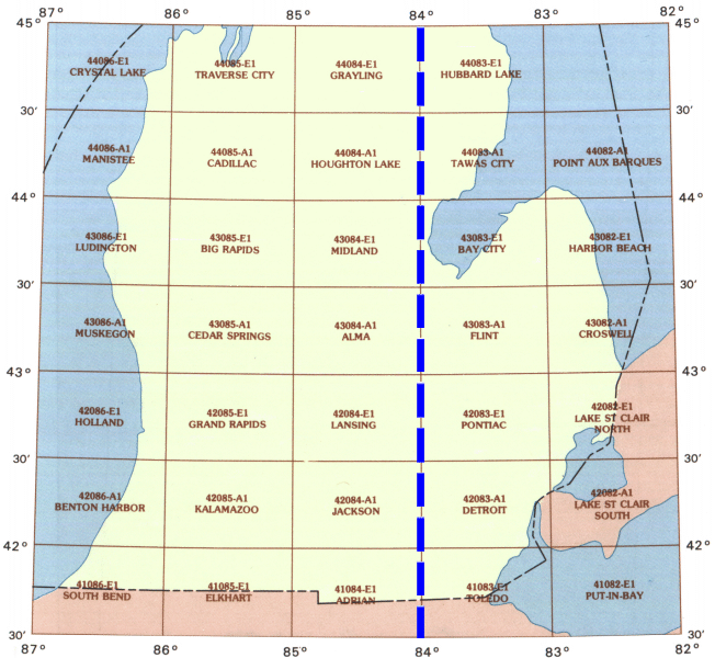

Michigan (Lower Penninsula)AdrianAlmaBay CityBenton HarborBig RapidsCadillacCedar SpringsCroswellCrystalDetroitElkhartFlintGrand RapidsGraylingHarbor BeachHollandHoughtonHubbardJacksonKalamazooLake Saint Clair NorthLake St Clair SouthLansingLudingtonManisteeMidlandMuskegonPointe aux BarquesPontiacSouth BendTawas CityToledoTraverse

| Adrian | Alma | Bay City | Benton Harbor | Big Rapids | Cadillac | Cedar Springs | Croswell | Crystal | Detroit | Elkhart | Flint | Grand Rapids | Grayling | Harbor Beach | Holland | Houghton | Hubbard | Jackson | Kalamazoo | Lake Saint Clair North | Lake Saint Clair South | Lansing | Ludington | Manistee | Midland | Muskegon | Pointe aux Barques | Pontiac | South Bend | Tawas City | Toledo | Traverse |

Hydrologic Modeling Community of Practice

  • Modeling Products
  • Groundwater Models
  • Surface Water Models
  • Food Chain Models
  • Multimedia Models
  • Data Provisioning and Modeling Tools
  • Information Sources
    • About This Website
    • Frequent Questions
    • Related Links
    • Distribution and Support Policy
Contact Us About Community of Practice
Contact Us to ask a question, provide feedback, or report a problem.
Last updated on January 10, 2025
  • Assistance
  • Spanish
  • Arabic
  • Chinese (simplified)
  • Chinese (traditional)
  • French
  • Haitian Creole
  • Korean
  • Portuguese
  • Russian
  • Tagalog
  • Vietnamese
United States Environmental Protection Agency

Discover.

  • Accessibility Statement
  • Budget & Performance
  • Contracting
  • EPA www Web Snapshot
  • Grants
  • No FEAR Act Data
  • Plain Writing
  • Privacy
  • Privacy and Security Notice

Connect.

  • Data
  • Inspector General
  • Jobs
  • Newsroom
  • Regulations.gov
  • Subscribe
  • USA.gov
  • White House

Ask.

  • Contact EPA
  • EPA Disclaimers
  • Hotlines
  • FOIA Requests
  • Frequent Questions
  • Site Feedback

Follow.