U.S. flag

An official website of the United States government

Here’s how you know

Dot gov

Official websites use .gov
A .gov website belongs to an official government organization in the United States.

HTTPS

Secure .gov websites use HTTPS
A lock (LockA locked padlock) or https:// means you’ve safely connected to the .gov website. Share sensitive information only on official, secure websites.

    • Environmental Topics
    • Air
    • Bed Bugs
    • Cancer
    • Chemicals, Toxics, and Pesticide
    • Emergency Response
    • Environmental Information by Location
    • Health
    • Land, Waste, and Cleanup
    • Lead
    • Mold
    • Radon
    • Research
    • Science Topics
    • Water Topics
    • A-Z Topic Index
    • Laws & Regulations
    • By Business Sector
    • By Topic
    • Compliance
    • Enforcement
    • Laws and Executive Orders
    • Regulations
    • Report a Violation
    • Environmental Violations
    • Fraud, Waste or Abuse
    • About EPA
    • Our Mission and What We Do
    • Headquarters Offices
    • Regional Offices
    • Labs and Research Centers
    • Planning, Budget, and Results
    • Organization Chart
    • EPA History

Breadcrumb

  1. Home
  2. National Aquatic Resource Surveys

Regional Results - National Coastal Condition Assessment 2015

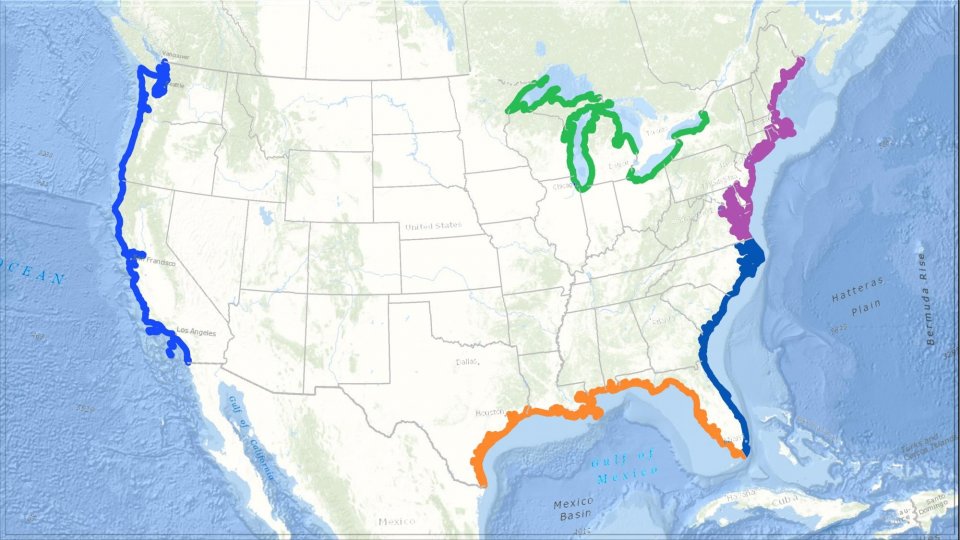
The National Coastal Condition Assessment (NCCA) reports on the health of estuarine and Great Lakes nearshore waters nationally as well as for four regional estuarine areas (the Northeast, Southeast, Gulf Coast, and the West Coast) and each of the Great Lakes separately. The following summaries include four indicators for ecological health and three indicators related to recreational use of these essential resources.

  • Northeast Coast Estuaries
  • Southeast Coast Estuaries
  • Gulf Coast Estuaries
  • West Coast Estuaries
  • Great Lakes Nearshore Waters

Additional regional and other subpopulation results are available on the interactive NCCA Dashboard, including information on individual indicators across all five categories and change in quality. 

Map of the continental United States showing the west coat, gulf coast, southeast, and northeast coastal areas outlined as well as the Great Lake  coastal areas.
 

National Aquatic Resource Surveys

  • Background
    • Indicators
    • Manuals
    • Map of Sampled Sites
  • NARS Data
    • Journal Articles
    • Applying the Data
    • LakeCat
    • StreamCat
  • National Coastal Condition Assessment
  • National Lakes Assessment
  • National Rivers and Streams Assessment
  • National Wetland Condition Assessment
  • Outreach Materials
Contact Us about National Aquatic Resource Surveys
Contact Us to ask a question, provide feedback, or report a problem.
Last updated on February 5, 2025
  • Assistance
  • Spanish
  • Arabic
  • Chinese (simplified)
  • Chinese (traditional)
  • French
  • Haitian Creole
  • Korean
  • Portuguese
  • Russian
  • Tagalog
  • Vietnamese
United States Environmental Protection Agency

Discover.

  • Accessibility Statement
  • Budget & Performance
  • Contracting
  • EPA www Web Snapshot
  • Grants
  • No FEAR Act Data
  • Plain Writing
  • Privacy
  • Privacy and Security Notice

Connect.

  • Data
  • Inspector General
  • Jobs
  • Newsroom
  • Regulations.gov
  • Subscribe
  • USA.gov
  • White House

Ask.

  • Contact EPA
  • EPA Disclaimers
  • Hotlines
  • FOIA Requests
  • Frequent Questions
  • Site Feedback

Follow.