
Climate Change in Coastal Communities
King Tides
What is a King Tide?
The king tide is the highest regular high tide of the year at a coastal location.
When is a King Tide?
King tides are a normal occurrence once or twice every year in coastal areas. In the United States, daily tides are predicted by NOAA.
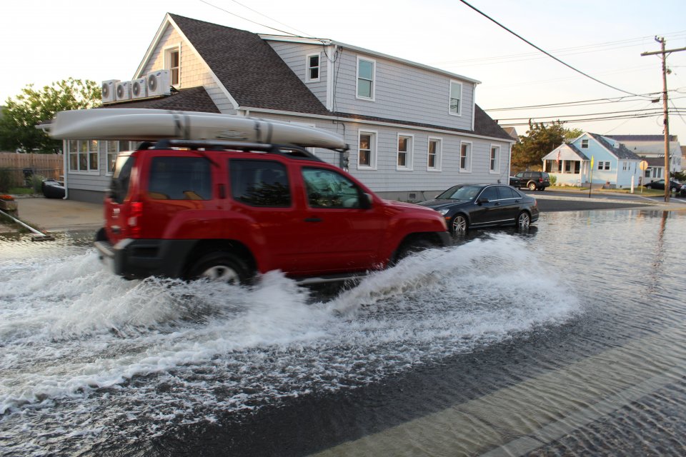
What do King Tides Show?
As a result of sea level rise, high tides are reaching higher and extending further inland than in the past. Low-lying shorelines are at increased risk of flooding because of rising seas.
The highest tide of the year provides a preview of how sea level rise will affect coastal places. As time goes by, the water level reached now during a king tide will be the water level reached at high tide on an average day.
Sea level rise will make today’s king tides become the future’s everyday tides. King tides provide a glimpse of the future. Photographs of king tide flooding can be used to raise awareness of potential sea level rise impacts and identify future flood-prone locations. The increased understanding of how sea level rise will affect a place is valuable information for residents and community decision-makers.
“A Peek into Our Future” from the EPA’s State of the Environment Photo Project.
Climate Change
The effects of climate change have been measured and observed in shoreline communities for decades. Tidal flooding happens more often, extreme storm events are increasing, the water table is higher, aquifers are getting saltier, and there are many such indicators of change.
Shoreline places will see all the temperature and precipitation changes that affect their general region. They face further risks from sea level rise and coastal flooding. If shoreline communities are already at risk from coastal storms, that will get worse as the sea rises.
Few places that have an economic tie to coastal waters (e.g., recreation, tourism, fishing, boating, shipping, etc.) can count on things remaining as they were for decades to come.
Flooding and storms are obvious dangers, but climate change impacts to coastal communities can come through many paths. Warmer water temperature can lead to fish kills or harmful algae blooms. Hotter summers can make being outdoors unbearable. Public health and safety, water and sewer infrastructure, plus all of the commerce, recreation and lifestyle characteristics that make a community special can be at risk.
Climate change stressors (warmer summers, warmer winters, warmer water temperature, increasing drought, increasing storminess, sea level rise and ocean acidification) introduce or exacerbate numerous and diverse risks that affect the future of a coastal community.
Climate Ready
To be climate ready means to have completed a risk-based climate change vulnerability assessment and to have taken any necessary actions so that there are no high risks from climate change stressors. High risks have greater likelihood of occurrence and greater effects when they do occur. These must be addressed otherwise places are just awaiting severe consequences.
Actions that are responses to a changing environment are adaptations. Community adaptation can take many forms—even system wide approaches. The EPA’s Climate Ready Estuaries program helps managers plan and adapt to climate change. Learn more about climate change at the coast, including what adaptation options are available, and get started on vulnerability assessments and adaptation planning.
CRE guides, reports, tools, training and links to other sites can help all places whether on the shoreline or thousands of miles away.