U.S. flag

An official website of the United States government

Here’s how you know

Dot gov

Official websites use .gov
A .gov website belongs to an official government organization in the United States.

HTTPS

Secure .gov websites use HTTPS
A lock (LockA locked padlock) or https:// means you’ve safely connected to the .gov website. Share sensitive information only on official, secure websites.

    • Environmental Topics
    • Air
    • Bed Bugs
    • Cancer
    • Chemicals, Toxics, and Pesticide
    • Emergency Response
    • Environmental Information by Location
    • Health
    • Land, Waste, and Cleanup
    • Lead
    • Mold
    • Radon
    • Research
    • Science Topics
    • Water Topics
    • A-Z Topic Index
    • Laws & Regulations
    • By Business Sector
    • By Topic
    • Compliance
    • Enforcement
    • Laws and Executive Orders
    • Regulations
    • Report a Violation
    • Environmental Violations
    • Fraud, Waste or Abuse
    • About EPA
    • Our Mission and What We Do
    • Headquarters Offices
    • Regional Offices
    • Labs and Research Centers
    • Planning, Budget, and Results
    • Organization Chart
    • EPA History

Breadcrumb

  1. Home
  2. Water Data and Tools

NHDPlusV1 Data

NHDPlus Version 1 Tools

NHDPlus Version 1 Documentation

Select the data region of your choice by clicking on the map below or selecting the name from the list.

Note: The unusual map edge appearance is due to the use of the USGS quad map edges. The map extent shows the extent of the available quad maps.
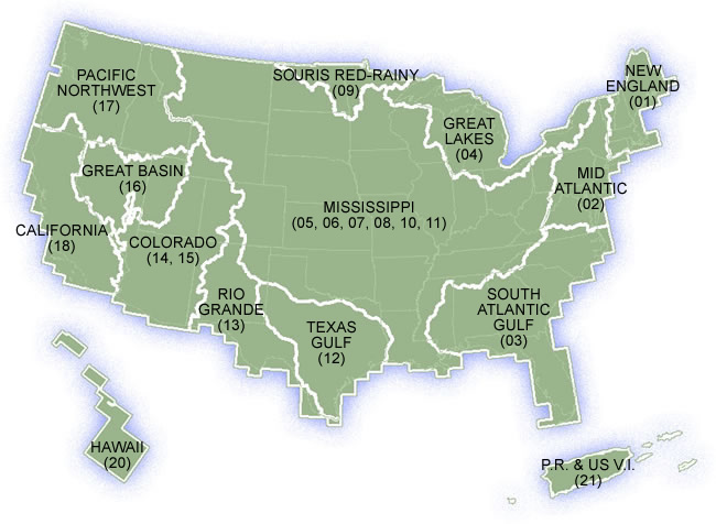
Pacific Northwest (17) California (18) Great Basin (16) Mississippi (05, 06, 07, 08, 10, 11) Colorado (14, 15) Rio Grande (13) Texas Gulf (12) Souris Red Rainy (09) Great Lakes (04) Mid Atlantic (02) New England (01) South Atlantic Gulf (03) Hawaii (20) Puerto Rico & US Virgin Islands (21)

map with data regions
New England (01)
Mid Atlantic (02)
South Atlantic Gulf (03)
Great Lakes (04)
Souris Red Rainy (09)
Texas Gulf (12)
Rio Grande (13)
Colorado (14, 15)
Great Basin (16)
Pacific Northwest (17)
California (18)
Hawaii (20)
Puerto Rico & US Virgin Islands (21)
Mississippi (05, 06, 07, 08, 10, 11)

Water Data and Tools

  • Integrated Water Analysis
  • Ambient Water Quality
  • Community Financing
  • Drinking Water
  • Water Restoration
  • Water Quality Models
Contact Us About Water Data and Tools
Contact Us to ask a question, provide feedback, or report a problem.
Last updated on October 8, 2024
  • Assistance
  • Spanish
  • Arabic
  • Chinese (simplified)
  • Chinese (traditional)
  • French
  • Haitian Creole
  • Korean
  • Portuguese
  • Russian
  • Tagalog
  • Vietnamese
United States Environmental Protection Agency

Discover.

  • Accessibility Statement
  • Budget & Performance
  • Contracting
  • EPA www Web Snapshot
  • Grants
  • No FEAR Act Data
  • Plain Writing
  • Privacy
  • Privacy and Security Notice

Connect.

  • Data
  • Inspector General
  • Jobs
  • Newsroom
  • Regulations.gov
  • Subscribe
  • USA.gov
  • White House

Ask.

  • Contact EPA
  • EPA Disclaimers
  • Hotlines
  • FOIA Requests
  • Frequent Questions
  • Site Feedback

Follow.