U.S. flag

An official website of the United States government

Here’s how you know

Dot gov

Official websites use .gov
A .gov website belongs to an official government organization in the United States.

HTTPS

Secure .gov websites use HTTPS
A lock (LockA locked padlock) or https:// means you’ve safely connected to the .gov website. Share sensitive information only on official, secure websites.

    • Environmental Topics
    • Air
    • Bed Bugs
    • Chemicals, Toxics, and Pesticide
    • Emergency Response
    • Environmental Information by Location
    • Health
    • Land, Waste, and Cleanup
    • Lead
    • Mold
    • Radon
    • Research
    • Science Topics
    • Water Topics
    • A-Z Topic Index
    • Laws & Regulations
    • By Business Sector
    • By Topic
    • Compliance
    • Enforcement
    • Guidance
    • Laws and Executive Orders
    • Regulations
    • Report a Violation
    • Environmental Violations
    • Fraud, Waste or Abuse
    • About EPA
    • Our Mission and What We Do
    • Headquarters Offices
    • Regional Offices
    • Labs and Research Centers
    • Planning, Budget, and Results
    • Organization Chart
    • EPA History

Breadcrumb

  1. Home
  2. Superfund Redevelopment Program

Redevelopment Mapper for Superfund and Brownfield Sites: Quick Start Instructions

Communities, developers, and state, local and Tribal governments may be interested in identifying Superfund or Brownfield sites as AI data centers. The Redevelopment Mapper for Superfund and Brownfield Sites is a helpful tool for assessing potential development opportunities, including data centers. This guide provides basic instructions for navigating the Redevelopment Mapper in order to identify sites of interest.

To access the app, please visit the Superfund Redevelopment Mapper. It is available in the following internet browsers: Google Chrome, Mozilla Firefox, Safari 3 and later, Microsoft Edge, Chrome for Android, and iOS Safari.

The app is not recommended for use in Internet Explorer. The website that hosts the app is not guaranteed to support that browser. 

screenshot of Superfund Redevelopment Mapper - full map of U.S.

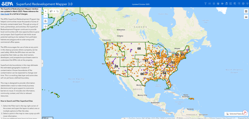
Finding Potential Sites for Redevelopment

The app’s map contains a selection of Brownfield sites over 100 acres in size and all National Priorities List and Superfund Alternative Approach Superfund sites. These sites can be searched and filtered using several parameters, including redevelopment context (e.g., proximity to transportation, energy infrastructure, population and water availability), location, size, site status and site name. 
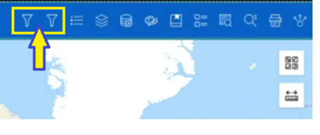
Filtering 

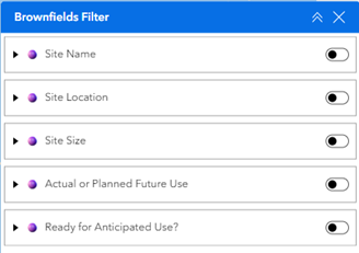
  • Select one of the Filter tools in the top right corner of the screen. The filter on the left is for Superfund sites and the filter on the right is for Brownfield sites. 

Screenshot shows two filter buttons identified by a yellow box and yellow arrow
  • Toggle the search groups on and off. Enter your search parameters in each field. 

screenshot shows Brownfields filter with toggle buttons for site name, location, size, etc.
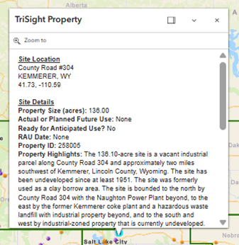
  • Select a point in the map to view a pop-up box with more information. 
Pop-up box shows more information about specific property.

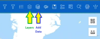
Explore site context using layers and the add data feature 

  • Click on the layers button to add information about site details, redevelopment potential, community context, infrastructure, demographics or the environment.  
  • Use the add data button to search for additional layers available through EPA’s Geoplatform or ArcGIS Online.  
Screenshot identifies two buttons. The fourth from the left is "layers" and fifth from the left is "add data."

Export a Search Result Table

  • Select the up arrow in the center of the bottom of the map.
  • Export the search results to a text file by selecting Actions>Export in the top right corner of the table and selecting Export to CSV.

For more detailed information about using the Redevelopment Mapper, reference the detailed user guide with full instructions. 

Superfund Redevelopment Program

  • What is Superfund Redevelopment?
    • Superfund Redevelopment Basics
    • What's New in Superfund Redevelopment?
    • Top 10 Questions to Ask When Buying a Superfund Site
    • Five Pillars of Success
    • SRP 20th Anniversary
  • Protecting Human Health & the Environment
    • Planning Support & Technical Assistance
    • Ready for Reuse (RfR) Determinations
    • Tax Incentives & Grants
  • Partnerships
    • Redevelopment Partnerships
    • Opportunity Zone Tax Incentives
    • Webinar Series
    • Videos
  • Promoting Strategies
    • Redevelopment Mapper
    • StoryMaps
    • Redevelopment Opportunities
    • Success Stories & Case Studies
    • Sustainable Redevelopment Tools
    • Reuse Awards
  • Policy
    • Redevelopment Tools
      • Site Owners, Developers and Prospective Purchasers
      • Community Members
      • Lenders
      • Local Governments
    • Policy & Guidance
  • Performance
    • Find Superfund Sites in Reuse
    • Redevelopment Economics
    • Performance Measures
  • Redevelopment Contacts
    • Regional Contacts
    • Ready for Reuse Fact Sheet Contact
Contact Us About the Superfund Redevelopment Program
Contact Us About the Superfund Redevelopment Program to ask a question, provide feedback, or report a problem.
Last updated on January 28, 2026
  • Assistance
  • Spanish
  • Arabic
  • Chinese (simplified)
  • Chinese (traditional)
  • French
  • Haitian Creole
  • Korean
  • Portuguese
  • Russian
  • Tagalog
  • Vietnamese
United States Environmental Protection Agency

Discover.

  • Accessibility Statement
  • Budget & Performance
  • Contracting
  • EPA www Web Snapshot
  • Grants
  • No FEAR Act Data
  • Plain Writing
  • Privacy and Security Notice

Connect.

  • Data
  • Inspector General
  • Jobs
  • Newsroom
  • Regulations.gov
  • Subscribe
  • USA.gov
  • White House

Ask.

  • Contact EPA
  • EPA Disclaimers
  • Hotlines
  • FOIA Requests
  • Frequent Questions
  • Site Feedback

Follow.