U.S. flag

An official website of the United States government

Here’s how you know

Dot gov

Official websites use .gov
A .gov website belongs to an official government organization in the United States.

HTTPS

Secure .gov websites use HTTPS
A lock (LockA locked padlock) or https:// means you’ve safely connected to the .gov website. Share sensitive information only on official, secure websites.

    • Environmental Topics
    • Air
    • Bed Bugs
    • Cancer
    • Chemicals, Toxics, and Pesticide
    • Emergency Response
    • Environmental Information by Location
    • Health
    • Land, Waste, and Cleanup
    • Lead
    • Mold
    • Radon
    • Research
    • Science Topics
    • Water Topics
    • A-Z Topic Index
    • Laws & Regulations
    • By Business Sector
    • By Topic
    • Compliance
    • Enforcement
    • Laws and Executive Orders
    • Regulations
    • Report a Violation
    • Environmental Violations
    • Fraud, Waste or Abuse
    • About EPA
    • Our Mission and What We Do
    • Headquarters Offices
    • Regional Offices
    • Labs and Research Centers
    • Planning, Budget, and Results
    • Organization Chart
    • EPA History

Breadcrumb

  1. Home
  2. Urban Waters Partnership
  3. 21 Designated Urban Waters Locations

Urban Waters and the Anacostia Watershed (Washington, DC/Maryland)

Anacostia River Area
  • View a larger version of this image
  • Photo gallery

Video: Off to the Races: Restoring America's Urban Waterways (YouTube)

Video: Anacostia Park Meaningful Engagement Cohort (YouTube)

Video: East Capitol Urban Farm (YouTube)

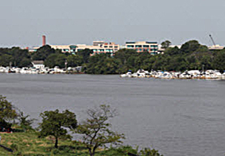
The Anacostia River watershed in the District of Columbia and Maryland is home to more than 800,000 people, 43 species of fish and some 200 species of birds. The watershed has been heavily urbanized over time, losing 6,500 acres of wetlands and 70% of its forest cover. Impervious surfaces now cover more than 25% of the watershed. Near the U.S. Capitol, the Anacostia River flows next to communities that suffer some of the region’s lowest employment rates, highest poverty rates, poorest health indicators and other challenges. 

Ecologically, the Anacostia River is steadily improving. The watershed has historically suffered from trash, toxins, sewage, runoff, oil, heavy metals and more due to adjacent agricultural, industrial and urban land uses, but government agencies and community partners have led major restoration efforts that could soon make the Anacostia swimmable and fishable once again. At the same time, however, inequality in DC region has grown, and some residents fear displacement caused by gentrification as the river improves. 

The river and its parks hold enormous potential to not only provide abundant wildlife habitat and improve water quality, but also to play a role in equitable community development and public health. The Anacostia Watershed UWP is a “partnership of partnerships,” helping to connect community partners and government agencies that work to address these overlapping issues. 

The UWP meets twice per year to check on progress and identify new projects for Federal collaboration. 

  • Find a list of upcoming meetings here.  

Do you have a watershed restoration project that could use Federal agency support? Please contact the Anacostia Ambassador.

2023-25 Anacostia UWFP Workplan

2020-21 Anacostia UWFP Workplan

Partnership in Action Report

Resources
  • Background Information
  • Program Contacts
  • Meeting & Events
  • Program Updates
  • Maps:
    • Riverwalk Trail
  • Anacostia Great Outdoors Factsheet
  • Anacostia Riverwalk Trail
  • East Capitol Urban Farm
  • Related Links
  • Accomplishments

Urban Waters Partnership

  • About the Urban Waters Partnership
  • 21 Designated Urban Waters Locations
    • Anacostia Watershed (DC/MD)
    • Blue River (Kansas City, MO)
    • Bronx and Harlem River Watersheds (NY)
    • Caño Martín Peña (PR)
    • Grand River / Grand Rapids (MI)
    • Greater Philadelphia Area / Delaware River Watershed (PA, NJ, DE)
    • Green-Duwamish Watershed (Washington)
    • Lake Pontchartrain Area / New Orleans (LA)
    • Los Angeles River Watershed (CA)
    • The Meramec River and Big River (Missouri)
    • Middle Rio Grande / Albuquerque (NM)
    • Mystic River Watershed (MA)
    • Northwest Indiana (IN)
    • Passaic River / Newark (NJ)
    • Patapsco Watershed / Baltimore Region (MD)
    • Proctor Creek Watershed / Atlanta (GA)
    • Rio Reimagined-Rio Salado Project
    • San Antonio River Basin within Bexar County (Texas)
    • South Platte Watershed, Headwaters to Denver Metropolitan Area (CO)
    • Walnut Creek Watershed / Raleigh (NC)
    • Western Lake Erie Basin, near Toledo (OH)
  • Federal Partners
Contact Us About the Urban Waters Partnership
Contact Us to ask a question, provide feedback, or report a problem.
Last updated on December 6, 2024
  • Assistance
  • Spanish
  • Arabic
  • Chinese (simplified)
  • Chinese (traditional)
  • French
  • Haitian Creole
  • Korean
  • Portuguese
  • Russian
  • Tagalog
  • Vietnamese
United States Environmental Protection Agency

Discover.

  • Accessibility Statement
  • Budget & Performance
  • Contracting
  • EPA www Web Snapshot
  • Grants
  • No FEAR Act Data
  • Plain Writing
  • Privacy
  • Privacy and Security Notice

Connect.

  • Data
  • Inspector General
  • Jobs
  • Newsroom
  • Regulations.gov
  • Subscribe
  • USA.gov
  • White House

Ask.

  • Contact EPA
  • EPA Disclaimers
  • Hotlines
  • FOIA Requests
  • Frequent Questions
  • Site Feedback

Follow.