
Where to Find Air Quality Smoke Reports - Fire and Smoke Map
The best place to find the official U.S. AQI for smoke is on the AirNow Fire and Smoke Map on the AirNow.gov website (Figure 10). The map is also available on the free AirNow smartphone app (Figure 11 below). AirNow.gov has current and forecast air quality data and maps for both ozone and PM.
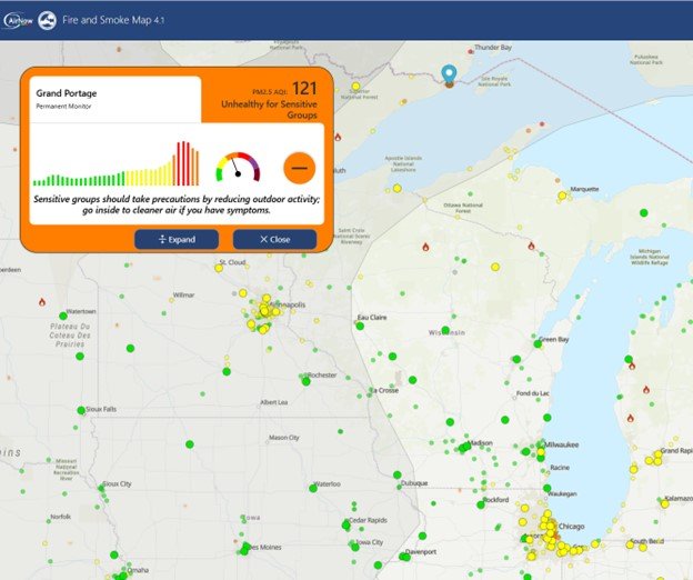
The Fire and Smoke Map provides continuous PM2.5 data from more than 1,700 state, local and Tribal air quality monitors that are part of the national regulatory air quality monitoring network. It also includes data from additional monitors to improve the spatial coverage of air quality information provided during smoke events, including temporary monitors and PM2.5 air sensors that are not part of the national regulatory air quality monitoring network. The map shows smoke plumes captured by satellites, wildfire locations and conditions, information about smoke and health, Smoke Outlooks (discussed in the next section) and other special announcements.
As smoke concentrations during a wildfire can change quickly, it is important to check the Fire and Smoke Map frequently for updates. Some state, local and Tribal air agency websites also provide the AQI.
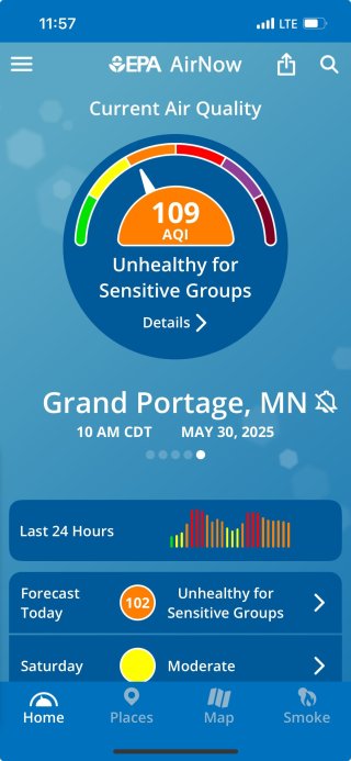
EPA's AirNow mobile app (Figure 11) is available for phones using Android and iOS operating systems. The app provides a simple interface for checking current and forecast air quality information that can be used to plan daily activities and learn how to protect health. To access the map on the smartphone app, tap the smoke icon in the bottom right-hand corner.
The app automatically displays the current air quality for the local area, and users can store multiple locations for quick reference. Users can also select to be notified of air quality forecasts for those areas via push notification.
| IOS | Android |
|---|---|

|

|
| Apple Store AirNow App | Google Play Store AirNow App |