U.S. flag

An official website of the United States government

Here’s how you know

Dot gov

Official websites use .gov
A .gov website belongs to an official government organization in the United States.

HTTPS

Secure .gov websites use HTTPS
A lock (LockA locked padlock) or https:// means you’ve safely connected to the .gov website. Share sensitive information only on official, secure websites.

    • Environmental Topics
    • Air
    • Bed Bugs
    • Cancer
    • Chemicals, Toxics, and Pesticide
    • Emergency Response
    • Environmental Information by Location
    • Health
    • Land, Waste, and Cleanup
    • Lead
    • Mold
    • Radon
    • Research
    • Science Topics
    • Water Topics
    • A-Z Topic Index
    • Laws & Regulations
    • By Business Sector
    • By Topic
    • Compliance
    • Enforcement
    • Laws and Executive Orders
    • Regulations
    • Report a Violation
    • Environmental Violations
    • Fraud, Waste or Abuse
    • About EPA
    • Our Mission and What We Do
    • Headquarters Offices
    • Regional Offices
    • Labs and Research Centers
    • Planning, Budget, and Results
    • Organization Chart
    • EPA History

Breadcrumb

  1. Home
  2. High-End Scientific Computing

Remote Sensing and Imagery Analysis Service

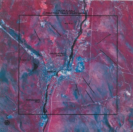
Chlor-Alkali Facility, fracture trace analysis, May 13, 1986.
The Remote Sensing and Imagery Analysis Service (RSIAS) provides geographically-based data collection and analysis using technologies such as satellite imagery, aerial photography, LIDAR (Light Detection And Ranging).

Services to EPA staff include comprehensive analysis of these data, which is commonly used in support of air quality, water quality and land remediation programs. Specifically, RSIAS provides EPA with a broad set of remote sensing services, including:

  • data collection
  • processing
  • interpretation
  • digital analysis
  • technical consulting
  • reporting

RSIAS services help EPA make better decisions, including in hazardous waste site evaluation. The results can speed the process of remediation at Superfund and Brownfields sites, by allowing EPA to determine the exact location and extent of areas of interest.

High-End Scientific Computing

  • RSIG
    • Download
    • RSIG3D Release History
    • RSIG3D Video Demonstrations
    • Web Access to RSIG Data
    • Reading Local/Remote CMAQ Files
    • Data Inventory
    • RSIG-Related Downloadable Data Files
    • How RSIG Regrids Data
    • Troubleshooting RSIG
  • EDM
    • About Estuary Data Mapper
    • Download & Install
    • Image Gallery
    • Release History
    • Data Inventory
    • Frequent Questions
    • Special Topics and Videos
      • EDM Basics
      • Nitrogen Sources and Loads
      • Develop Seagrass Models
      • Seagrass Updates (2024)
      • Web Coverage Service (WCS)
      • WCS & Decision Support Tools
      • Land-Use Scenarios
  • RETIGO
    • Enter Your Data in RETIGO
    • Timestamp Converter
    • Tutorial: How to use RETIGO
    • Tutorial: Create RETIGO file from Excel
    • Frequent Questions
Contact Us About High-End Scientific Computing
Contact Us to ask a question, provide feedback, or report a problem.
Last updated on April 8, 2025
  • Assistance
  • Spanish
  • Arabic
  • Chinese (simplified)
  • Chinese (traditional)
  • French
  • Haitian Creole
  • Korean
  • Portuguese
  • Russian
  • Tagalog
  • Vietnamese
United States Environmental Protection Agency

Discover.

  • Accessibility Statement
  • Budget & Performance
  • Contracting
  • EPA www Web Snapshot
  • Grants
  • No FEAR Act Data
  • Plain Writing
  • Privacy
  • Privacy and Security Notice

Connect.

  • Data
  • Inspector General
  • Jobs
  • Newsroom
  • Regulations.gov
  • Subscribe
  • USA.gov
  • White House

Ask.

  • Contact EPA
  • EPA Disclaimers
  • Hotlines
  • FOIA Requests
  • Frequent Questions
  • Site Feedback

Follow.