
How the CWMP Data are Being Used
EPA uses Coastal Wetland Monitoring Program (CWMP) data to monitor the health of Great Lakes coastal wetlands and assess changes over time (Great Lakes CWMP Results and Major Findings). This information is included in the triennial State of the Great Lakes Reports, which summarize the status and trends of the Great Lakes ecosystem. The EPA also uses CWMP data to help prioritize Great Lakes coastal wetland restoration, enhancement and protection efforts. Decision making based on reliable scientific data, like those collected by the CWMP, can help maximize the effectiveness of conservation efforts and evaluate the outcomes of these efforts. As of 2019, over 52,000 acres of Great Lakes coastal wetlands have been restored or enhanced through Great Lakes Restoration Initiative (GLRI)-funded projects or have received greater protection through changes to management policy or legal protective status.
- Coastal Wetland Restoration
- Coastal Wetland Enhancement
- Protection of Coastal Wetlands
- Web-based Resources
Coastal Wetland Restoration
The goal of coastal wetland restoration is to restore functional and/or ecological characteristics that existed prior to wetland degradation or destruction following European settlement and the industrial revolution. Coastal wetlands are dynamic natural systems that experience constant changes, which can be beneficial or adverse to wetland health. Examples of adverse impacts include increased agricultural or urban land use, excess nutrient and sediment runoff, and rapidly changing water levels and climate patterns.
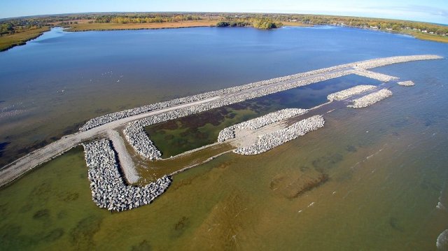
Restoration projects are designed to counter adverse impacts. Projects include efforts to restore the surface water connectivity of coastal wetlands to the Great Lakes by removing structures such as failed culverts, sediment berms resulting from excessive erosion, and constructed dikes and other artificial features that prevent the natural movement of water and aquatic organisms. Other examples of restoration projects include reducing nutrient and sediment runoff, controlling populations of invasive plant and animal species, and re-establishing native coastal wetland plant communities. Many of these types of projects have been successfully completed at the Rochester Embayment Area of Concern (AOC) (Figure 1).
Resource managers can gain insights into how to design restoration projects by analyzing CWMP data. CWMP data also can support efforts to evaluate the outcomes of restoration efforts.
Coastal Wetland Enhancement
The goal of coastal wetland enhancement is to improve the physical structure, habitat connectivity or the ecological function of a coastal wetland by modifying one or more physical, chemical or biological characteristics of the wetland.
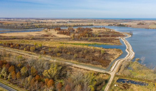
Coastal wetland enhancement projects that involve physical structure improvements include promoting or discouraging woody plant species and creating bypass structures or deep-water channels to provide spawning fish with greater access to protected areas of the wetland interior (Figure 2). Projects that involve improvement of ecological function include the control or eradication of invasive species (e.g., Phragmites australis, Typha spp.) to improve habitat for native species as well as artificial management of both water levels and the area of open water in wetlands to benefit migrating waterfowl.
Protection of Coastal Wetlands
The protection of coastal wetlands includes actions taken to maintain existing and naturally functioning systems and prevent their destruction or degradation.
Coastal wetlands selected for protection often have high economic, ecological or cultural value. These wetlands include natural and constructed coastal wetlands that provide storm surge protection to public marinas and other shoreline development; spawning and nursery habitat for recreational game fish; critical habitat for common, threatened and endangered, and non-fish game species; and habitat for cultural resources such as plants for fiber and weaving materials, and foods such as wild rice.
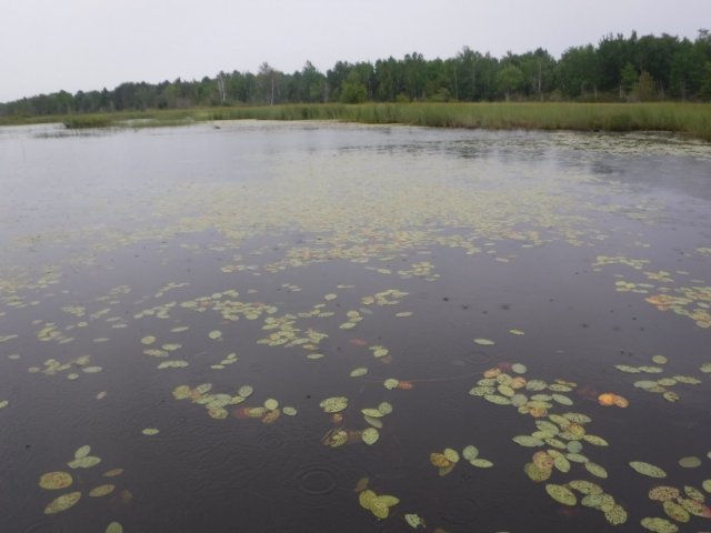
Protecting existing coastal wetlands is a cost-effective way to maintain water quality, wildlife habitat and recreational opportunities. Protection efforts are evident in the coastal wetlands along the Lake Superior shoreline of northern Wisconsin, which are among the healthiest wetlands in the Great Lakes. The benefits of protecting coastal wetlands can be amplified by protecting coastal wetlands adjacent to other protected lands. For example, the Wisconsin Department of Natural Resources has utilized support from the GLRI to acquire and protect high quality coastal wetland habitats adjacent to the Bark Bay Slough State Nature Area (Figure 3).
Web-based Resources
Several web-based tools and resources that use or provide access to CWMP data have been created with support from the GLRI to assist resource managers with the planning and prioritization of restoration, enhancement and protection efforts. These web-based tools include:
Great Lakes Coastal Wetland Restoration Assessment
This wetland mapping tool is designed for use by public agencies and other resource managers to identify coastal wetlands that would benefit from restoration, enhancement or protection efforts. This tool is a collaboration between the U.S. Geological Survey and the Upper Midwest and Great Lakes Landscape Conservation Cooperative.
Great Lakes Coastal Wetland Decision Support Tool (CWDST)
Designed by several CWMP collaborators, the CWDST provides public, tribal and private organizations with access to CWMP data and geographic analysis tools. Local and regional coastal zone managers and planners can use this tool to assess and prioritize coastal wetland sites for restoration and protection.
Great Lakes Site Mapping Tool (SMT)
Also designed by CWMP collaborators, the SMT provides public, tribal and private organizations access to a basic mapping tool that includes the locations of all coastal wetlands monitored by the CWMP and information about their condition and the plant and animal communities present. Users can access additional information specific to monitored coastal wetland sites, including monitoring status, site characteristics and condition, and photographs illustrating examples of wetland types and research activities.
GLRI CWMP Web Map
The EPA has created the GLRI CWMP Web Map, which displays the locations of all coastal wetlands within the Great Lakes Basin in the United States and Canada, including those monitored by the CWMP during 2011-2019. The web map also shows the locations of GLRI-funded restoration, enhancement and protection projects that are either completed, in progress or planned as well as each of the eight Great Lakes states and their coastal zones. Access to this web map and video tutorials describing how to navigate map layers and advanced features are provided below.

Click here to open the GLRI CWMP web map application.
The GLRI CWMP web map application can be used to explore coastal wetland types, GLRI-funded projects and other map layers relevant to the Great Lakes Basin watershed. Once opened in a new window, click on the
(information) symbol at the top right banner for additional information on the features and tools in the web map.
CWMP Web Map Application
GLNPO CWMP Web Map Application
Back to: About the Great Lakes Coastal Wetland Monitoring Program