
Where Great Lakes Coastal Wetlands Occur
Great Lakes coastal wetlands occur throughout the Great Lakes Basin in the United States and Canada in coastal areas directly influenced by the water level of one of the Great Lakes or their connecting river systems. Great Lakes coastal wetlands can be found along mainland, island and major channel shorelines.
Approximately 72%, or 383,197 acres, of all Great Lakes coastal wetlands are located in the United States and, of that amount, 281,665 acres of coastal wetlands occur along the mainland and island shorelines within the state of Michigan.[1] All Great Lakes coastal wetlands in Canada are within the province of Ontario.
On This Page:
Coastal Wetland Types
The Coastal Wetland Monitoring Program (CWMP) categorizes coastal wetlands into three broad wetland types based on coastal geology and landscape position, the dominant source of water, and the degree of connection between the wetland and a Great Lake. The three categories of coastal wetland types include: riverine, barrier-protected and lacustrine.
Riverine Wetlands
Riverine wetlands comprise the greatest percentage of coastal wetland acreage across the Great Lakes Basin with a total of about 227,844 acres (43%).[1] These wetlands often exist where a river mouth meets a Great Lake (Figure 1). Riverine wetlands also are associated with tributaries, both large and small, and can be found along the connecting river systems that flow between the Great Lakes and at the head of the St. Lawrence River.[2]

Barrier-Protected Wetlands
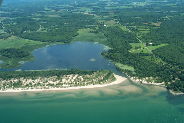
Barrier-protected wetlands comprise the second greatest percentage of coastal wetland acreage across the Great Lakes Basin with a total of about 187,568 acres (35%).[1] Barrier wetland systems are typically found along stretches of Great Lakes coastline that are exposed to harsh wind and wave conditions. The wind and wave action deposits sand and other sediments creating physical barriers that protect the wetland (Figure 2). Barrier-protected wetlands are either periodically or continuously connected to a Great Lake by a channel or inlet.[2]
Lacustrine Wetlands
Lacustrine wetlands are the least common coastal wetland type in both acreage and numbers across the Great Lakes Basin, comprising a total of about 117,526 acres (22%).[1] Lacustrine wetlands are generally located in areas directly exposed to the waters of the Great Lakes, but with less exposure to the harsh wind and wave conditions that typically create barrier-protected wetlands (Figure 3). This type of wetland typically forms in large bays (e.g., Saginaw Bay) or where nearshore coastal features and other processes dampen wave action.[2]
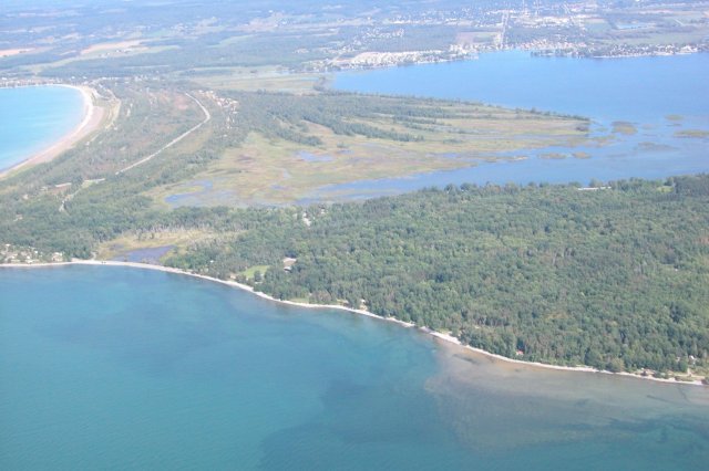
Figure 4 illustrates the distribution of these three wetland types (riverine, barrier-protected, lacustrine) across the Great Lakes Basin. Total area and number of Great Lakes coastal wetlands in each Great Lake, broken out by wetland type, are shown in Table 1 and Table 2.
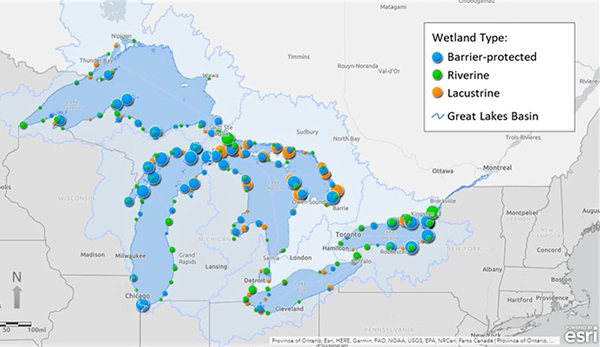
Table 1. Total Coastal Wetland Acreage by Wetland Type for Each of the Great Lakes.
| Great Lake | Acreage of Coastal Wetlands by Wetland Type | Total Acreage of Coastal Wetlands | ||
|---|---|---|---|---|
| Riverine | Barrier- Protected | Lacustrine | ||
| Superior | 29,239 | 36,185 | 4,185 | 69,609 |
| Huron* | 65,280 | 57,677 | 60,052 | 183,009 |
| Michigan | 41,001 | 64,750 | 11,755 | 117,506 |
| Erie** | 55,910 | 9,921 | 30,477 | 96,308 |
| Ontario | 36,414 | 19,035 | 11,057 | 66,506 |
| Great Lakes Basin | 227,844 | 187,568 | 117,526 | 532,938 |
The wetland acreage estimates cited above represent coastal wetlands primarily 4.94 acres (2 ha) or larger that are within the Great Lakes Basin. Coastal wetlands range in size (area) from 0.07 to 18,063.6 acres, with a mean of 197.7 acres, a median of 22.0 acres and a standard deviation of 805.2 acres. The current extent of Great Lakes coastal wetlands is estimated at approximately 532,938 acres or 833 square miles. Source: CWMP 2019 wetland polygon shapefile (modified from Great Lakes Coastal Wetland Consortium 2004).
* Lake Huron includes wetlands associated with the St. Marys River.
** Lake Erie includes wetlands associated with the St. Clair River, Lake St. Clair and the Detroit River.
Table 2. Number of Coastal Wetlands by Wetland Type for Each of the Great Lakes.
| Great Lake | Number of Coastal Wetlands by Wetland Type | Total Number of Coastal Wetlands | ||
|---|---|---|---|---|
| Riverine | Barrier- Protected | Lacustrine | ||
| Superior | 102 | 149 | 59 | 310 |
| Huron* | 213 | 257 | 508 | 978 |
| Michigan | 92 | 326 | 111 | 529 |
| Erie** | 92 | 36 | 59 | 187 |
| Ontario | 355 | 208 | 128 | 691 |
| Great Lakes Basin | 854 | 976 | 865 | 2,695 |
The number of Great Lakes Basin coastal wetlands cited above represents wetlands primarily 4.94 acres (2 ha) or larger that are within the Great Lakes Basin watershed. Coastal wetlands range in size (area) from 0.07 to 18,063.6 acres, with a mean of 197.7 acres, a median of 22.0 acres and a standard deviation of 805.2 acres. Source: CWMP 2019 wetland polygon shapefile (modified from Great Lakes Coastal Wetland Consortium 2004).
* Lake Huron includes wetlands associated with the St. Marys River.
** Lake Erie includes wetlands associated with the St. Clair River, Lake St. Clair and the Detroit River.
Explore Wetlands – GLRI CWMP Web Map
The locations of Great Lakes coastal wetlands sampled under the CWMP can be explored using the GLRI CWMP web map. To learn about the other features of this web map, see: ‘How the CWMP Data are Being Used’.

Click here to open the GLRI CWMP web map application.
The GLRI CWMP web map application can be used to explore coastal wetland types, GLRI-funded projects and other map layers relevant to the Great Lakes Basin watershed. Once opened in a new window, click on the
(information) symbol at the top right banner for additional information on the features and tools in the web map application.
References
[1] Great Lakes Coastal Wetland Consortium. 2004. Great Lakes Coastal Wetland Inventory. A geospatial dataset published on behalf of the Great Lakes Commission. Ann Arbor, MI.
[2] Albert, D.A., Wilcox, D.A., Ingram, J.W., Thompson, T.A. 2005. Hydrogeomorphic classification for Great Lakes coastal wetlands. J. Great Lakes Res. 31. 129-146
Back to: About the Great Lakes Coastal Wetland Monitoring Program