
2015 AOC Investigation and Remediation: Groundwater Monitoring
Background
Developing an adequate groundwater monitoring well network in the area around Red Hill is a key requirement of the 2015 Administrative Order on Consent (AOC). The groundwater monitoring network serves multiple purposes.
Monitoring wells provide regular data on contaminant concentrations in the groundwater under and around the Red Hill facility. The current monitoring well network consists of 12 monitoring locations, three of which are directly under the Red Hill tanks and nine of which are located in the area around the facility. These nine monitoring wells provide data on the nature and extent of any fuel contamination migrating away from the facility. Samples of groundwater are taken every three months and analyzed for a number of chemicals that are contained in the fuel stored at Red Hill.
The monitoring well network provides data that will help refine the Groundwater Flow and Fate & Transport Models. Monitoring wells also provide important data on groundwater elevations that are critical inputs to the Groundwater Flow Models. Data collected from the wells provides information that helps to validate the results of modeling. Geologic information gathered during the installation of new monitoring wells also provides essential data.
The Navy has installed and is currently operating 12 groundwater monitoring wells. To date, only very low concentrations of chemicals of concern have been detected in some of the wells not located under the Red Hill tanks. A map of the existing groundwater monitoring locations can be viewed on the Additional Documents page.
Groundwater Testing Results
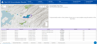
EPA is pleased to present an application developed to provide you with a simple way to view up-to date information about groundwater quality around the Red Hill Bulk Fuel Storage Facility in Hawaiʻi. Learn more at the Groundwater Results Application.
The results of all groundwater monitoring are submitted to the Hawai'i Department of Health and can be viewed at their website.
In the Final approved Red Hill AOC SOW Section 6 & 7 Scope of Work the Navy commits to developing a number of interim reports that address the installation of additional groundwater monitoring wells, the extent of available data that can be used to develop models, identification of data gaps, sampling and analysis procedures, assessing natural attenuation, and the development of conceptual site models and groundwater flow models. As of August 25, 2017, the Regulatory Agencies have received interim deliverables addressing the installation of new groundwater monitoring wells, the sampling and analysis of groundwater and the Existing Data Summary and Evaluation Report for Groundwater Flow and Contaminant Fate and Transport Modeling. The most recent plan received from the Navy is for the installation of up to 12 new groundwater monitoring wells in addition to the currently operating 12 groundwater wells. The details of the Navy’s plan to expand the groundwater monitoring network are included in the Monitoring Well Installation Work Plan Addendum 02, submitted to the Regulatory Agencies on August 25, 2017, is available for viewing at right.
Documents
- Letter from EPA and State of Hawaii DOH to US Navy: Disapproval of Consolidation and Optimization of the Groundwater Sampling Programs (pdf)
- EPA and Hawai'i DOH Letter to US Navy: Preliminary Investigation of PFAS (pdf)
- Groundwater Monitoring Well Network Recommendation Letter (pdf)
- Monitoring Well Installation Work Plan Addendum 2, 25 August 2017 (pdf)
- Sampling and Analysis Plan (SOP) - 19 January 2017 (pdf)
- Red Hill Monitoring Well Installation Work Plan Addendum - 4 January 2017 (pdf)
- Navy Red Hill Revised Monitoring Well Installation Work Plan - 17 July 2016 (pdf)
- Additional Documents