
National Aquatic Resource Surveys (NARS) Research
- Technical Support
- DNA-based Biomonitoring
- Indicator Development
- Enhancing NARS and Data Interpretations
- Extensions and Linkages
- Additional Resources
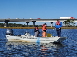
EPA research supports and advances National Aquatic Resource Surveys (NARS) monitoring and assessment through the application of high-quality, innovative science. Over 40 years of research has been invested into the NARS survey designs, field protocols, survey methods, and statistical analyses. EPA researchers in the Office of Research and Development (ORD) provide critical science and technical support needed to implement NARS, interpret the results, and ensure that the surveys address current and emerging threats to aquatic resources. The knowledge, tools, and training developed by EPA help decision makers use NARS data to manage aquatic resources proactively and adaptively.
Technical Support
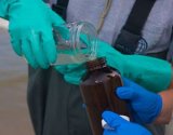
ORD scientists provide technical support to the NARS program, ensuring that the scientific integrity and underpinnings of the program are maintained for each of the four surveys. The NARS team continuously improves processes, resulting in higher quality NARS data and reduced time for data delivery to partners.
The NARS program in ORD includes the following areas of research:
- Producing the sample frame and survey designs for each NARS cycle;
- Creating the field app used by crews to collect site data;
- Managing laboratory analysis of water samples;
- Calculating metrics and indicators that are part of the final datasets;
- Reviewing data for quality assurance;
- Conducting statistical analyses;
- Producing and interpreting population estimates and final results;
- Developing national reports;
- Harmonizing datasets;
- Managing NARS data;
- Developing tools to promote use and accessibility of NARS data; and
- Providing regional, state, and Tribal technical support.
Explore the final results for each survey through the NARS Reports and Dashboards.
DNA-based Biomonitoring
DNA-based biomonitoring provides novel, robust, and cost-effective methods for assessing the ecological integrity of aquatic habitats. Regional and state entities have explored using DNA methods, including environmental eDNA, in their routine monitoring. EPA researchers are advancing the science of biomonitoring with the goal of incorporating DNA-based indicators into the NARS assessments. Samples to support this work are collected during NARS surveys of streams, rivers, and lakes.
Research Focus
- Testing and developing protocols for field sampling.
- Determining optimal DNA preservation and extraction techniques.
- Establishing molecular and bioinformatics workflows.
- Developing informative DNA indicators that can be used alongside existing methods at a national scale.
Science Matters Story: How EPA Scientists Use Fish eDNA to Assess Estuarine Health
Estuaries provide habitat for fish and wildlife, protect coastal shorelines, and contribute to local and national economies, but estuary resilience is under constant pressure from the land (e.g., development, pollution) and the sea (e.g., sea level rise, hurricanes). Fish communities can reflect the general health of an estuary. EPA researchers are developing and testing eDNA sampling methods as a modern approach for collecting basic fish community information. The non-invasive eDNA techniques could replace traditional catch sampling to assess status and changes in fish communities and inform EPA and land managers about estuarine condition and restoration success.
Learn how EPA researchers are assisting with the National Coastal Condition Assessment in Florida’s Pensacola and Perdido Bays.
Indicator Development
Ecological indicators are the foundation of NARS and its assessments. Indicators are used to measure the physical, chemical, and biological condition of the Nation's waters and to evaluate the stressors that affect condition. EPA researchers improve current indicators and address critical gaps in NARS reporting through the development of new indicators and tools.
Research Focus
- Developing benthic, nutrient, and genetic indicators in The Great Lakes.
- Developing indicators of watershed-scale human development in coastal watersheds.
- Developing indicators of nitrogen processing in wetlands.
- Developing indicators of alteration of stream flow and alteration of lake levels.
- Developing indicators of coastal acidification.
With the improvement of current indicators and the production of new indicators, NARS can relate ecological condition to resource management activities and expand its response to emerging issues in aquatic ecology and requests for support from regions, states, and Tribes.
Learn more about The Suite of Indicators Currently Reported by NARS.
Enhancing NARS and Data Interpretations
EPA researchers constantly evaluate and improve the scientific underpinnings and data interpretations of NARS to ensure that the assessments remain on the cutting-edge. These efforts increase the utility of NARS data, both within EPA and in state and Tribal agencies.
Research Focus
- Improving the approach used to determine reference sites, critical to support indicator development and perform assessments.
- Evaluating, improving, and expanding assessment thresholds used to assign “good”, “fair”, and “poor” conditions, including those for indicators.
- Developing new methods for ranking the relative importance of stressors to the condition of aquatic ecosystems.
- Advancing approaches that use diatom traits and genus-level taxonomic data to improve our ability to assess diatom assemblage condition.
- Using remote sensing to supplement field-based measurements.
Project Spotlight: Developing New Assessment Approaches Using Diatoms
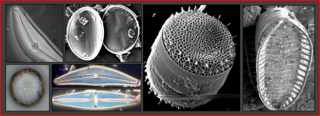
Diatoms are a group of algae widely used in aquatic biological assessments because of their fast response to environmental changes related to human activities. NARS produces a rich diatom dataset, but the national scale of NARS creates challenges in consistently identifying diatom taxonomy at the species level. To address this, ORD researchers are developing new approaches using coarser, genus-level data, that avoids the issues with diatom species identification and is faster and more cost-effective to obtain. These efficient new approaches may allow for the use of diatoms in future NARS assessments as an indicator of aquatic condition.
Read EPA’s Science Matters article, "Diatoms: Solving an Identity Issue."
Extensions and Linkages
Hundreds of EPA researchers rely on NARS data or utilize NARS field campaigns to support ground-breaking research that captures a broad range of areas. NARS tools and approaches can also be used in other monitoring and assessment activities to which the Agency is tied. These extensions of the tools and approaches developed for NARS not only improve data available for assessments, but also increase the visibility and importance of NARS across EPA, states, Tribes, and other partners.
Examples of NARS-Supported Research
- Evaluating extensive approaches versus intensive approaches to monitoring and assessment in the Great Lakes.
- Applying the National Coastal Condition Assessment approach on the St. Lawrence River to increase Regional and State capacity to manage large connecting river systems in the Great Lakes.
- Connecting pollution sources and loads to NARS aquatic condition.
- Quantifying the magnitude of water quality and land use as drivers of stream communities across the U.S.
- Linking NARS Fish Habitat Quality Index to State National Fish Habitat Assessment.
Project Spotlight: Using the National Aquatic Resource Surveys (NARS) to Tell Us About Mountain Lakes
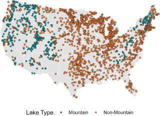
Mountain lakes are important places to many for swimming and boating, but until recently, their status across the U.S. was unknown. Using the NARS data and survey design, EPA researchers were able to determine that mountain lakes are generally in better condition than lowland lakes. For example, mountains lakes are less likely to have harmful algal blooms (HABs) that can produce toxins that are harmful to people, pets, and wildlife. Read the full analysis about mountain lakes.
Learn more about EPA’s Harmful Algal Blooms (HABs) research.
Related Research
- NARS Outreach Materials
- Applications of NARS Research
Research Publications
NARS Datasets and Tools
- NARS Data: Data from the NARS that are publicly available for download.
- NARS Tools: Tools and training videos related to the NARS and statistical surveys.
- spsurvey: an R programming language package that implements a design-based approach to statistical inference, with a focus on spatial data.
- spmodel: an R programming language package used to fit and summarize spatial models and make predictions at unobserved locations.