
Linear Regression: EPT Taxa Richness vs. Percent Sand and Fines for Minnesota Streams
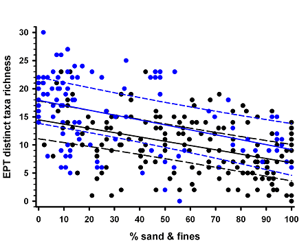
Plot
- Analysis: Linear regression
- Independent variable: Percent (%) sand and fines
- Dependent variable: EPT (Ephemeroptera, Plecoptera and Trichoptera) taxa richness
- Classification: Using Omernik level II Ecoregions with dummy variable = 0 for Ecoregions 46, 47, and 51 and dummy variable = 1 for Ecoregions 50 and 52
- Key: symbols = observations, solid line = mean line, dashed line = 95% prediction limit, black lines and symbols = Ecoregions 46, 47 and 51, blue lines and symbols = Ecoregions 50 and 52
- Sample size: n = 267
Model
- Ecoregions 50 and 52: EPT richness = 14.473 - 0.0763*(% sand & fines)
- Ecoregions 46, 47 and 51: EPT richness = 17.945 - 0.0875*(% sand & fines)
- r2 = 0.304
- Date: 6 October, 2006
| Variable | Estimate | t value | p |
|---|---|---|---|
| Intercept | 14.473 | 15.53 | |
| Ecoregion class | 3.472 | 2.89 | 0.004 |
| % Sand & fines | -0.0763 | -5.37 | <0.0001 |
| % Sand & fines x Ecoregion class | -0.0112 | -0.51 | 0.61 |
Data Analysis
- Model generated using SAS Proc GLM with the solution option. The 95% prediction limits were calculated using the equation in step 9 of box 14.3 from Sokal and Rohlf (1995). The intercept, slope, grand mean of % sand & fines, and corrected sums of squares were calculated using Proc REG and Proc UNIVARIATE.
- The ecoregions were aggregated into two classes because a preliminary ANOVA indicated that the base material for bedded sediments, % coarse substrates, was significantly greater in Ecoregions 50 and 52 than in Ecoregions 46, 47, and 51. Percent coarse substrates, however, did not significantly differ within either group.
- Replicate visits to a site were excluded from the data set.
Data Origin
- Agency: Minnesota Pollution Control Agency, St. Paul, Minnesota
- Location: Minnesota - analyses restricted to wadeable sites (52 km2 < watershed area < 523 km2) from the five ecoregions indicated below.
- Omernik Level III Ecoregions examined include: 46 (Northern Glaciated Plains), 47 (Western Corn Belt Plains), 50 (Northern Lakes and Forests), 51 (North Central Hardwoods), and 52 (Driftless Area).
Sampling Design
- Data collected: 1996 through 2004.
Contact
Michael B. Griffith, griffith.michael@epa.gov, (513) 569-7034