
Section 17: Air - Waste Characteristics & Targets
17.1 Waste Characteristics
- All evaluations are restricted to sources with non-zero gas or particulate containment factor values and to substances associated with such sources.
- Exclude any substance that is associated solely with a source or sources with both gas and particulate containment factor values of zero.
Toxicity
- Obtain the toxicity factor value from the Superfund Chemical Data Matrix (SCDM) for each hazardous substance associated with the site.
- EPA should be consulted whenever values are needed for substances not appearing in SCDM.
Mobility
- Gaseous substances associated with the site
- Assign a value of 1 for mobility for a gaseous substance found in an observed release by direct observation or by chemical analysis.
- Otherwise, obtain the gaseous mobility value from SCDM.
- EPA should be consulted whenever values are needed for substances not appearing in SCDM.
- Particulate substances associated with the site
- Assign a value of 0.02 for a particulate substance found in an observed release.
- All other particulate substances are assigned the same particulate mobility value based on the location of the site using the particulate migration potential value.
Waste Characteristics
- Select the most hazardous substance: the substance at the site with the highest product of toxicity times mobility.
- Multiply toxicity/mobility by the value for the hazardous waste quantity for the air migration pathway.
- This product is capped at 108.
- The waste characteristics value is obtained from Hazard Ranking System (HRS) Table 2-7. The maximum value is 100.
17.2 Targets
Target Distance Limit and Categories
- Targets are associated with distance categories based on their distance to the nearest source with a non-zero gas or particulate containment factor value. (HRS Guidance Manual Highlight 10-7 : Determining Areas of Actual and Potential Contamination With Multiple Sources)
- Exclude from consideration any source with a gas and particulate containment factor value of zero.
- Include only those targets located within the 4 miles of a source at the site.
- If an observed release is established beyond the 4-mile target distance limit, include those additional targets located closer to the site than the location at which the observed release is established.
- This essentially creates a new distance category for this site defined as the area between 4 miles and the specified distance from any source at the site.
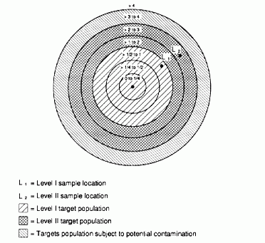
Level of Contamination
- A distance category (and the targets located within it) is considered subject to Level I contamination if it contains a Level I sample or is closer to the site than a Level I sample.
- A distance category (and the targets located within it) is considered subject to Level II contamination if
- it contains a Level II sample and
- no portion of the distance category lies between the site and any Level I sample.
- Potential contamination is assigned to all other distance categories within the target distance limit.
- Levels of contamination are determined as discussed in Section 6 using the following benchmarks only:
- National Ambient Air Quality Standards
- National Emission Standards for Hazardous Air Pollutants
- 10-6 Cancer Risk Screening Concentrations for inhalation exposures
- Noncancer Risk Screening Concentrations for inhalation exposures.
- These values can be obtained from SCDM. EPA should be consulted whenever values are needed for substances not appearing in SCDM.
Nearest Individual
- Evaluated based on the shortest distance from any source at the site to any residence or regularly occupied building or area and considering the level of contamination associated with that distance.
- Values are assigned as follows:
- Level I Contamination: 50
- Level II Contamination: 45
- Potential Contamination: HRS Table 6-16
Population
- Based on the number of residents, workers, and students associated with each target distance category
- Assign a level of contamination to each target distance category as discussed above. Target Distance Category
- Level I population value = total population subject to Level I contamination x 10
- Level II population value = total population subject to Level II contamination x 1
- Potential population value = total distance-weighted population subject to potential contamination x 0.1
- Use HRS Table 6-17 to determine the distance-weighted population for each target distance category.
- Note in HRS Table 6-17 that the first distance category is "On a source." This could include workers whose duties take them onto a source and residents whose homes were built on top of a source.
Resources
- Assign a value of 5 if one or more of the following are located within 1/2 mile of a source at the site:
- Commercial agriculture
- Commercial silviculture
- Major or designated recreation area.
- Otherwise, assign a value of 0.
- Note that the target distance limit for resources is 1/2 mile.
Sensitive Environments
- The same sensitive environment types and factor values are used in the air and surface water migration pathways.
- Only wetlands meeting the requirements of 40 CFR 120.2 (moved from 40 CFR 230.3) are eligible for evaluation.
- A sensitive environment is considered as located within a distance category if the shortest distance measured from any part of that environment to any source at the site lies between the specified distances.
- Example: A portion of a national park is located within the 4-mile target distance limit. The shortest distance from the park boundary to a source at the site is 1,700 feet (ft). The national park is considered to be located within the 1/4-mile to 1/2-mile distance category (1,320 ft < 1,700 ft < 2,640 ft).
- A non-wetland sensitive environment lying within two or more distance categories is considered associated with the closest distance category.
See HRS Guidance Manual Highlight 10-13: Identifying Sensitive Environments in the Air Pathway.
- Only two contamination levels are assigned to sensitive environments.
- Actual contamination (This is not further divided into Level I and Level II because there are no air benchmarks.)
- Potential contamination
- Wetland areas can be evaluated both as a wetland and as other types of sensitive environments (e.g., critical habitat).
- Wetlands are evaluated by acreage rather than frontage.
- Wetlands are divisible for purposes of determining actual or potential contamination.
- Example: A 200 acre wetland crosses the boundary between the 1/4-1/2 mile distance category and the 1/2-1 mile distance category. Fifty acres lie in the closer category and 150 in the further category. Based on sampling data, the 1/4-1/2 mile distance category is considered subject to actual contamination while the 1/2-1 mile distance category is not. For purposes of determining the wetland rating value, the wetland is treated as though it were two wetlands: one 50 acres in size and subject to actual contamination, the other 150 acres in size, subject to potential contamination, and associated with the 1/2-1 mile distance category.
- Actual contamination
- Calculate the total acreage of wetlands subject to actual contamination and assign a wetland rating value from HRS Table 6-18.
- Sum the total sensitive environmental values for each sensitive environment subject to actual contamination. Don't forget to include any wetlands subject to actual contamination.
- The actual contamination value is the sum of these two totals.
- Potential contamination
- For each distance category subject to potential contamination, calculate the total acreage of wetlands associated with the distance category and assign a wetland rating value from HRS Table 6-18.
- For each distance category, sum the total sensitive environment values for each sensitive environment associated with the distance category. Do not include any wetlands lying wholly or partially in a distance category subject to actual contamination.
- The potential contamination value is the sum of the distance category totals divided by 10.
- The air migration pathway score based solely on sensitive environments is limited to 60 pathway points.
Continue to Section 18: Soil Exposure Pathway - Resident Population Threat
Navigate to another section of the course:
Section 1: Regulatory Context of the Hazard Ranking System
Section 2: Site Assessment Process
Section 4: Source Characterization
Section 5: Waste Characteristics
Section 6: Likelihood of Release
Section 8: Groundwater - Aquifers
Section 9: Groundwater - Likelihood of Release
Section 10: Groundwater - Waste Characteristics & Targets
Section 11: Surface Water - Likelihood of Release
Section 12: Surface Water - Drinking Water Threat
Section 13: Surface Water - Human Food Chain Threat
Section 14: Surface Water - Environmental Threat
Section 15: Surface Water - Ground Water to Surface Water Component
Section 16: Air - Likelihood of Release
Section 17: Air - Waste Characteristics & Targets
Section 18: Soil Exposure - Resident Population Threat