Stormwater Management Technologies: Innovative Monitoring Equipment
Following contamination of infrastructure, state and local agencies may need to implement control measures to contain or redirect stormwater. EPA is developing and testing technologies to support stormwater management.
Go back to the Stormwater Management Implementation Control Technologies page.
Disclaimer: Mention of trade names, products, or services does not convey official EPA approval, endorsement, or recommendation.
Innovative Stormwater Monitoring Equipment
Flow control devices can be used at outfalls to streams is to manage flooding and erosion, improve aquatic habitat and improve water quality. To evaluate flow control and to determine optimal conditions for sampling, EPA is evaluating various flow and depth sensors.
Industrial environmental flow sensors are in the range of $1000 and up, thus, EPA is evaluating components that will allow us to construct our own sensors for just $100 - $200. The challenges are to develop sensors that are cost effective and have adequate connectivity to transmit data to computers and other devices such, as cell phones. In this way the EPA devices will contribute to the Internet of Things (IoT): a network of physical objects that are embedded with sensors, software, and other technologies for the purpose of connecting and exchanging data with other devices and systems over the internet.
EPA has been in discussions with industries and other government agencies who are have successfully built low cost sensors and data loggers for their own purposes. EPA is utilizing components from several designs to develop sensors that will relay information on stream flow and depth, so that remotely operated samplers can be deployed to collect samples under optimal conditions.
EPA will compare its simply constructed data loggers to industry standard equipment for accuracy, robustness, reliability, and durability. The ability to inexpensively construct these sensors using readily purchased materials is intended to motivate citizen scientists to get involved supporting water utilities in monitoring outfalls to streams. It is not practicable, from a cost perspective, for utilities to monitor all outfalls, yet monitoring for conditions such as dry weather, illegal dumping, or sewer overflows is important to water quality and healthy ecosystems.
Flowing Water ScopeTM
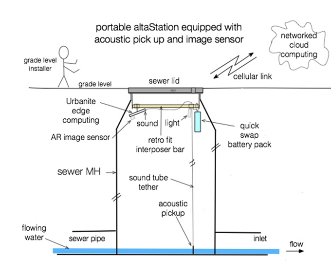
In 2012, EPA entered into a cooperative research and development agreement (CRADA) with a small business technology company, UrbanAlta, to develop and patent a unique, state-of-the-art flow monitoring system. Until then, flow measurement involved decentralized, standalone equipment with limited networking capability. The methods were costly, potentially dangerous because human entry was required for installation and maintenance, consumed large battery cells that need frequent replacement, were not adept at measuring low flows, and required removal from monitoring sites to calibrate equipment.
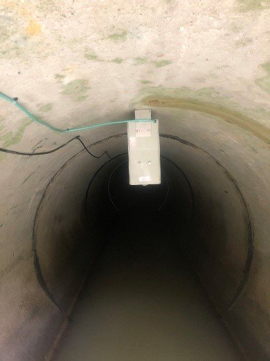
EPA, working with UrbanAlta, built a test bed at EPA’s Test and Evaluation (T&E) Facility in Cincinnati, Ohio, to develop a flow monitoring system (Flowing Water ScopeTM) that was easily and safely deployed. It is reliable, accurate, self-calibrating, centrally managed, and cost-effective. Testing simulated a pipe flowing beneath a manhole; however, the technology is adaptable to any water flow system.
The technology utilizes interposers to connect and integrate circuits so that they behave as a single device to achieve performance improvements at reduced power requirements. In this application, image and acoustical sensors, lighting, and a rechargeable battery pack are mounted on the interposer with a cellular link to network cloud computing for data processing.
Visual Monitoring
Width-based flow measurement is the process for producing flow velocity from a digital image of water flowing through an open channel using site-specific data and monitored data of surface and/or subsurface velocity measurement. Alternatively, if velocity is not captured, flow measurement can still be performed by other methods, such as the Gauckler-Manning formula, or with the assistance of an aid (e.g., Palmer-Bolus flume).
Flow width can be captured using several image sensors. A thermal image sensor will provide a distinct contrast between the water surface and the channel walls unless water temperature is the same as the channel wall temperature. The width of flow can also be calculated by using a range camera (such as those that employ infrared speckled interferometry). This not only captures the width of flow but also can be used to calculate the distance of the water surface from the range camera, providing a straightforward method to determine changes in flow depth. A visible spectrum image sensor and structured light can be paired to provide the necessary information to quantify flow width (and additionally, velocity and water quality data). Flow width (and surface velocity/water quality) can be quantified if at least the center of the channel and one water surface boundary is visible from the perspective of the image sensor.
Audio Monitoring
Sound wave sampling and detection is used to provide a signature of the flow throughout the audio spectrum. The audio signature partially consists of frequency amplitude, frequency distribution, and direction of the detected audio signal (upstream or downstream). The signature provides an indication of flow conditions such as surcharge (e.g., burbling with high level of water) or the approaching flow conditions before water reaches the manhole (e.g., based upon the rush/roar of approaching water).
Researchers demonstrated the Flowing Water ScopeTM at the T&E Facility and patented the device. The Federal Laboratory Consortium, Midwest Region, also granted the device a Partnership Award in 2014.
Sommer Messtechnik RQ-30 Flow Sensor
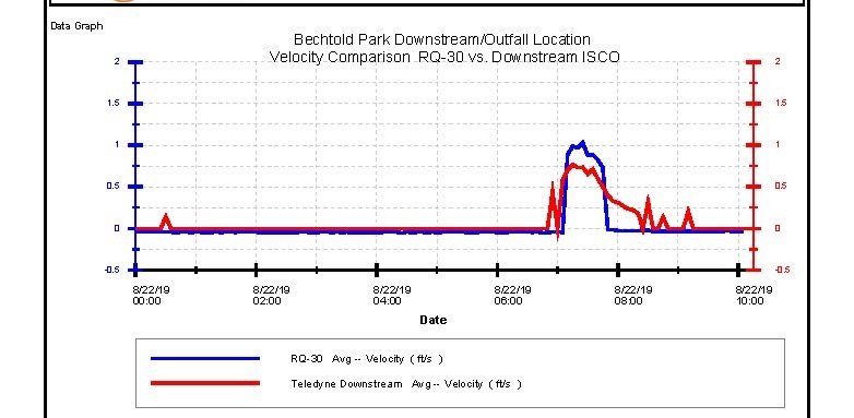
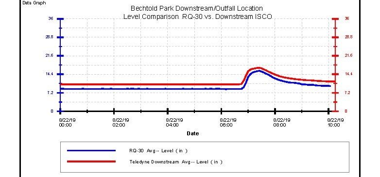
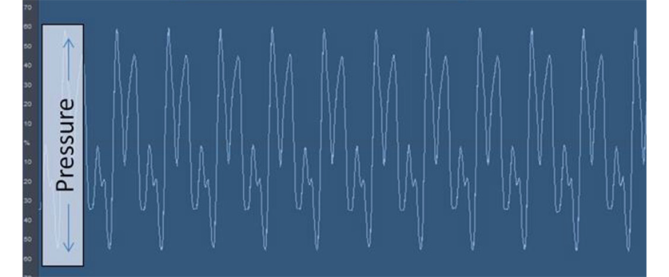
EPA tested one commercially available sensor, the RQ-30A flow sensor manufactured by Sommer Messtechnik, GmbH of Austria. This innovative sensor’s performance was compared to a representative commercially available proven technology (Teledyne ISCO 2150 Area Velocity Module) already installed at Bechtold Park, Cincinnati, Ohio.
The RQ-30 radar sensor continuously measures the discharge of rivers and channels. Unlike the Teledyne unit, which requires a submersible data logging unit, the RQ-30 device combines two contact-free radar measurement methods to determine the surface velocity and water level. Because of the contact-free measurement the system cannot be harmed by sediments and floating refuse, or impact stream flow. The result is very low maintenance and an increased reliability, especially in flood water situations.
The sensor can be easily mounted on bridges, superstructures of channels or the ceilings of closed channels.
The flow velocity is measured using the Doppler effect. A radar signal with a frequency of 24 GHz is transmitted towards the water surface. The signal is partially reflected, the moving water causes a frequency change due to the Doppler effect. A spectral analysis is performed on the reflected signal and the water’s surface velocity is calculated. The signal must be transmitted at an angle to the water surface. This angle is internally measured to automatically correct the calculated velocity.
The water level is calculated using a term measurement. The radar device sends short pulses perpendicular to the water surface. To conclude the distance to the water surface and thus the water level, the time between transmission and reception of these pulses is measured.
In the graphs below depicting water level and velocity measured in the Bechtold Park outfall, there is good agreement between measurements made with the RQ-30 and the industry standard Teledyne ISCO.