
Excess Food Opportunities Map
On this page:
- About the U.S. EPA Excess Food Opportunities Map
- Using the Map
- Supporting Resources
- Related Tools
- Related Programs
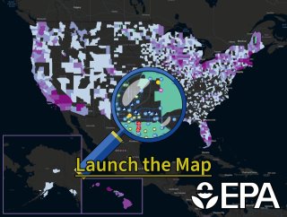
About the U.S. EPA Excess Food Opportunities Map
The U.S. EPA Excess Food Opportunities Map supports nationwide diversion of excess food from landfills. The interactive map identifies and displays facility-specific information about potential generators and recipients of excess food in the industrial, commercial and institutional sectors. It also provides estimates of excess food by generator type.
The map displays the locations of over 960,000 potential excess food generators. These include:
- correctional facilities.
- educational institutions.
- farmers markets.
- food banks, food pantries, and soup kitchens.
- healthcare facilities.
- hospitality industry.
- food manufacturing and processing facilities.
- food wholesale and retail.
- restaurants and food services.
The map also displays the locations of communities with source separated organics programs, refrigerated warehousing and storage facilities, and over 15,000 potential recipients of excess food. These include:
- anaerobic digestion facilities.
- composting facilities.
- food banks, food pantries, and soup kitchens.
EPA updated the map to Version 3.1. The updates and additions include:
- New data on food banks, food pantries, and soup kitchens obtained from Hunger Free America.
- Update to the farmers market layer with expanded data from USDA's Local Food Directories.
- Composting facilities added from EPA's Disaster Debris Recovery Tool to create one consistent EPA list of composting facilities (which now includes some mulching facilities). EPA also fixed mapped location errors for some composting facilities. Finally, EPA added community composting sites using data provided by the Institute for Local Self-Reliance.
- Additional stand-alone and on-farm anaerobic digestion (AD) facilities added to the AD layer.
- Layers added directly from USDA's Food Access Research Atlas and Food Environment Atlas.
EPA updated all other layers in Version 3.0, released in July of 2023. For more information on the changes in Version 3.1, visit the Frequent Questions about the U.S. EPA Excess Food Opportunities Map webpage.
EPA provides the mapped establishments and their locations for informational purposes only. The Agency does not guarantee the accuracy or completeness of the information provided as it has not been verified.
Using the Map
EPA designed the map interface for intuitive use and to allow you to display multiple layers at once, as well as create customized filtered views to look at any area of the country in detail. Access the User Guide.
The map will help you learn about potential sources of excess food in your region and potential non-landfill recipients, such as food banks, food pantries, and soup kitchens, as well as composting and anaerobic digestion facilities. You can also use this map to inform and identify:
- Excess food management decisions at the local level.
- Potential sources of food for rescue and redistribution.
- Potential feedstocks for compost, anaerobic digestion or other uses such as animal feed.
- Potential infrastructure gaps for managing excess food.
Technical functionalities of the map include the ability to:
- Access information about individual potential generators and recipients by turning on and off map layers and access full datasets in the accompanying attribute table.
- Search for excess food generators and recipients in an area of interest, such as a county, or within a certain radius of a selected point.
- Print the current map view in a variety of formats and layouts.
- Download data for individual layers or filtered views directly from the map or download the full map dataset from EPA's Geoplatform. You may need additional software to view the dataset. Refer to EPA’s Free Viewers and Readers webpage.
Supporting Resources
- Frequent questions about Version 3.1 of the map.
- User guide for Version 3.1 of the map.
- Technical methodologies for Versions 1.0, 2.0, 2.1, 3.0, and 3.1 of the map.
- Training webinar on Version 2.0 of the map.
- Slides from training webinar on Version 2.0 of the map.
- Training webinar on Version 1.0 of the map.
Related Tools
- EPA's Wasted Food Scale.
- Preventing Wasted Food in Your Community: A Social Marketing Toolkit.
- Composting Food Scraps in Your Community: A Social Marketing Toolkit.
- Recycling Infrastructure and Market Opportunities Map.
- Toolkit for Reducing Food Waste and Packaging.
- Managing and Transforming Waste Streams.
- Model Recycling Program Toolkit.
- Wasted Food Infographics.