
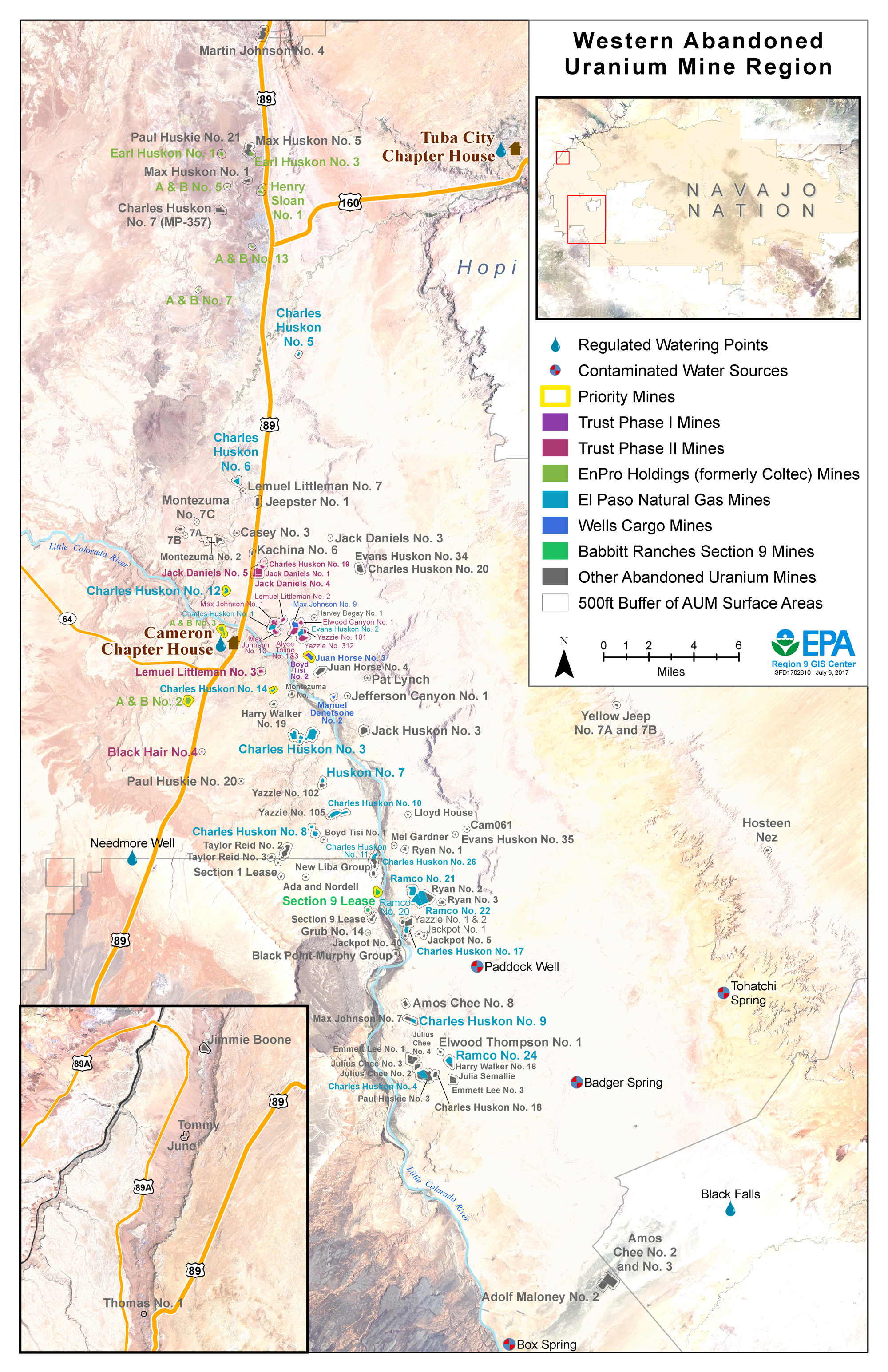
Western Abandoned Uranium Mine Region
There are more than 100 abandoned uranium mines (AUMs) in the Western AUM Region. These mines are generally located along the Little Colorado River and Highway 89, and are in the Cameron, Coalmine Canyon, Bodaway/Gap, and Leupp Chapters.
Background
- 111 abandoned uranium mine claims in region
- 7 priority mine claims
- 28 mine claims to be assessed by potentially responsible parties
- 14 mine claims to be assessed by Phase 1 and Phase 2 of the Navajo Environmental Response Trust
- 1 additional priority mine claim without a potentially responsible party
Mines in the Western AUM Region were operated in the 1950s and 1960s by a number of different companies before being abandoned. While the Navajo Nation Abandoned Mine Lands program addressed many of the physical hazards associated with these mines, EPA and Navajo Nation EPA are working to address remaining chemical and radiological hazards that may pose a risk to community members.
Legal Agreements and Upcoming Mine Assessments
EPA, in partnership with Navajo Nation EPA, is working to identify companies responsible for the mines and to oversee detailed assessments of the mines. In the Western AUM Region, several agreements have been completed allowing for mine assessments:
- In 2013, EPA signed a legal agreement called an Administrative Order on Consent with El Paso Natural Gas to assess 19 mine claims in western Navajo Nation. In 2017, EPA issued a modification to the Administrative Order on Consent to continue work at the 19 mines.
- In 2015, the Phase 1 Navajo Environmental Response Trust was established, which included funding for the assessment of one mine claim in the area.
- In 2016, EPA signed a legal agreement with Babbitt Ranches to assess the Section 9 Lease Abandoned Uranium Mine site.
- Also in 2016, the Phase 2 Navajo Environmental Response Trust was established, which included funding for the assessment of 13 mine claims in the area.
- In 2017, EPA signed a legal agreement with EnPro Holdings to assess eight AUMs, including two priority mines.
These assessments will allow EPA, working with Navajo Nation EPA, to develop clean up options for the mines. EPA will continue to involve the community during mine assessments and as we begin to consider cleanup options.
Community Involvement
In the communities of Cameron, Coalmine Canyon, Bodaway/Gap, and Leupp, residents should know and participate in what EPA is doing in their community, and have a say in it. The main purpose of engaging community members is to give them the opportunity to become involved in EPA’s activities and help shape the decisions that are made affecting their community.
To further this goal, EPA developed the Western Navajo Abandoned Uranium Mine Region Community Involvement Plan with input from community members. The Community Involvement Plan is a living document to guide community members and EPA in meaningful information sharing regarding cleanup activities in the Western Abandoned Uranium Mine Region.
Who Is the Community?
Mines in the area are located along the Little Colorado River and Highway 89, and are located in the Cameron, Coalmine Canyon, Bodaway/Gap, and Leupp Chapters. Some of the mines are located near Homesites, especially those who live near the bridge in Cameron over the Little Colorado River. Additional mines are located along the Little Colorado River south of Cameron and along Highway 89 north of Cameron. Affected community members include those who graze livestock in these areas or have vending stalls along the highway.
Current Community Involvement Activities
EPA works with Chapter Officials as well as community members for all outreach activities and information sessions which are conducted with cultural sensitivity. EPA continues to:
- Report at Chapter meetings and District 3 Grazing meetings
- Report at Community Land Use Planning Committee meetings
- Present at EPA-led meetings in the community
- Attend special events such as the Western Nation Fair and Cameron Community Celebration
- Present at schools such as Dzil Libei Elementary School
- Produce factsheets relevant to the Superfund cleanup process and upcoming work in the region
- Inform residents door-to-door when work will be taking place near their Homesite
- Meet with Chapter officials and Navajo Nation Council Delegates
Past Community Involvement Activities
EPA completed the following activities in the community:
- Reported at numerous Cameron, Coalmine Canyon, and Bodaway/Gap Chapter meetings
- Reported at numerous District 3 Grazing meetings
- Reported at Cameron, Coalmine Canyon, and Bodaway/Gap Community Land Use Planning meetings
- Conducted Community Involvement Plan interviews in Cameron, Coalmine Canyon, and Bodaway/Gap
- Met with Chapter officials and Council Delegates
- Presented on warning signs and upcoming field work at the Cameron Senior Center and the Cameron community building
- Participated in Bennett Freeze tours with the Navajo Nation Office of the President and Vice President, Navajo Nation, Council Members, Arizona State Legislature Members, and staffers of US Congressional Representatives
- Set up information booths at the Western Nation Fair in Tuba City, the Cameron Community Celebration, and the Community Uranium Exposure-Journey to Healing Mobile Clinic in Cameron
- Presented at Dzil Libei Elementary School in 2014, 2015, and 2016
Partnerships
Remedial Project Managers
Estrella Armijo
armijo.estrella@epa.gov)
(415) 595-9110
Colin Larrick
larrick.colin@epa.gov)
(415) 972-3086
Community Involvement Coordinator
Priscilla Tom
tom.priscilla@epa.gov)
(505) 240-0093
EPA continues to work and strengthen relationship with a number of organizations focused on uranium and radiation, including:
- Navajo Nation Environmental Protection Agency
- Navajo Nation Abandoned Mine Lands Program
- Navajo Environmental Response Trust
- Indian Health Service Community Uranium Exposure-Journey to Healing
- Indian Health Service Radiation Exposure Screening and Education Program
- Office of Navajo Uranium Workers
- Navajo Birth Cohort Study
- Navajo Nation Department of Health Community Health Representatives
- Bureau of Indian Affairs
- Indian Health Service
- Agency for Toxic Substances and Disease Registry
- Nuclear Regulatory Commission
- Department of Energy
- University of New Mexico
- Northern Arizona University
- Forgotten People Community Development Corporation
- Coconino County Board of Supervisors
- Others as suggested by community members and local officials
Cleanup Progress Timeline
There are more than 100 abandoned uranium mines located in the Western AUM Region. Mining in the region took place in the 1950s and 1960s and reclamation efforts began in the 1990s. Click on the different years below to learn about recent and upcoming activities.
1990s
The Navajo Nation Abandoned Mine Lands Program performs reclamation activities to address physical hazards at most of the mine sites.
2008-12
EPA conducts initial screening of radiation levels on all mines in the region, and prioritizes seven mines for cleanup.
2013
EPA signs a legal agreement with El Paso Natural Gas to perform assessment work at 19 mine claims.
2014
- EPA meets with Cameron, Coalmine Canyon, and Bodaway/Gap residents and officials to conduct interviews for Community Involvement Plan
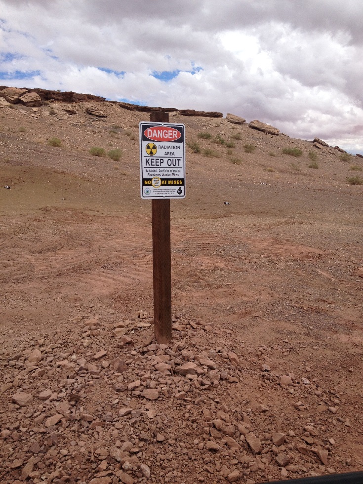
- EPA places radiation warning signs in front of A&B No. 3 Mine
2015
- EPA and El Paso Natural Gas discuss the scope of work and technical issues while developing a Workplan for the upcoming assessment activities
- El Paso Natural Gas presents to the Cameron community
- The Phase 1 Navajo AUM Environmental Response Trust is established, which includes funding for the assessment of one mine in the Cameron area
2016
- El Paso Natural Gas places fences and radiation warning signs at accessible mines
- Gamma radiation surveys of mine sites and background areas begin for El Paso Natural Gas mine sites
- EPA signs a legal agreement with Babbitt Ranches to perform assessment work at one mine claim
- The Phase 2 Navajo Environmental Response Trust is established, which includes funding for the assessment of 13 mines in the Cameron area
2017
- El Paso Natural Gas completes gamma radiation scanning of all 19 mine claims in their scope of work with EPA and Navajo Nation EPA oversight
- The Phase I Navajo Environmental Response Trust performs a detailed assessment at Boyd Tisi No. 2 with Navajo Nation EPA and EPA oversight
- EPA signs a modification to the legal agreement with El Paso Natural Gas
- Babbitt Ranches places warning signs and completes gamma radiation and background studies at the Section 9 Lease site
- The first Trustee for the Phase 2 Environmental Response Trust, Derrith Watchman-Moore, is selected. Ms. Watchman-Moore will conduct the assessment of 13 mines in the Cameron area
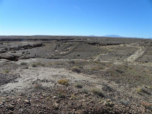
Site Photographs
-

Charles Huskon No. 7 Mine.
-

Radiation warning sign in front of A&B No. 3 Mine.
-

EPA and Navajo Nation EPA present at the Bodaway/Gap Chapter meeting.