U.S. flag

An official website of the United States government

Here’s how you know

Dot gov

Official websites use .gov
A .gov website belongs to an official government organization in the United States.

HTTPS

Secure .gov websites use HTTPS
A lock (LockA locked padlock) or https:// means you’ve safely connected to the .gov website. Share sensitive information only on official, secure websites.

    • Environmental Topics
    • Air
    • Bed Bugs
    • Chemicals and Toxics
    • Climate Change
    • Emergency Response
    • Environmental Information by Location
    • Environmental Justice
    • Greener Living
    • Health
    • Land, Waste, and Cleanup
    • Lead
    • Mold
    • Pesticides
    • Radon
    • Science Topics
    • Water Topics
    • A-Z Topic Index
    • Laws & Regulations
    • By Business Sector
    • By Topic
    • Compliance
    • Enforcement
    • Guidance
    • Laws and Executive Orders
    • Regulations
    • Report a Violation
    • Environmental Violations
    • Fraud, Waste or Abuse
    • About EPA
    • Our Mission and What We Do
    • EPA Administrator
    • Headquarters Offices
    • Regional Offices
    • Labs and Research Centers
    • Planning, Budget, and Results
    • Organization Chart
    • EPA History
    • Staff Directory
WaterSense
Contact Us

Water Budget Data Finder

Budget Data Finder banner
Irrigation professionals using the WaterSense Landscape Water Budget Tool may use the Water Budget Data Finder to determine peak watering month and the appropriate evapotranspiration and rainfall values for a specific United States zip code.

Information presented in the Data Finder comes from the World Water and Climate Atlas, a project of the International Water Management Institute (IWMI). EPA would like to thank IWMI for the use of this data.

Enter Zip Code:  
 

Rainfall Map

How the Data Finder Works

Information presented in the Data Finder come directly from the World Water and Climate Atlas, a project of the International Water Management Institute (IWMI). EPA would like to thank IWMI for the use of this data. IWMI's model relies on historic information collected from thousands of global weather stations from 1961-1990. For information regarding this model, please visit IWMI's Web site.

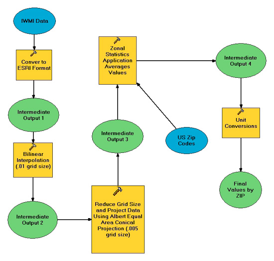
For purposes of this tool, the IWMI data has been summarized with an average value for each United States zip code. WaterSense is unable to offer this information internationally, although data is available directly from the IWMI Climate Atlas Web query. IWMI's data has been converted from ".grd" files into "ascii" files and imported to ESRI ArcGIS version 9.3 for processing. The graphic below summarizes all processing that has occurred to make this information available on a summarized basis.

How the data finder works chart

  • WaterSense Home
  • About WaterSense
  • WaterSense Products
  • WaterSense for Kids
  • Our Water
  • Outdoors
  • Homes
  • Commercial Buildings
  • WaterSense Partners
  • Specifications and Certifications
Contact Us to ask a question, provide feedback, or report a problem.
Last updated on February 6, 2023
United States Environmental Protection Agency

Discover.

  • Accessibility Statement
  • Budget & Performance
  • Contracting
  • EPA www Web Snapshot
  • Grants
  • No FEAR Act Data
  • Plain Writing
  • Privacy
  • Privacy and Security Notice

Connect.

  • Data.gov
  • Inspector General
  • Jobs
  • Newsroom
  • Open Government
  • Regulations.gov
  • Subscribe
  • USA.gov
  • White House

Ask.

  • Contact EPA
  • EPA Disclaimers
  • Hotlines
  • FOIA Requests
  • Frequent Questions

Follow.